Ebbe Mountains
| Ebbe Mountains | |
|---|---|
|
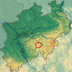
Location of the Ebbegebirge in North Rhine-Westphalia |
|
|
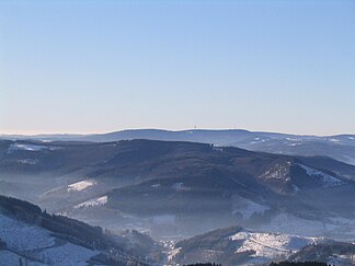
Ebbe Mountains from the northeast ( Schomberg observation tower ) |
|
| Highest peak | Nordhelle ( 662.7 m above sea level ) |
| location | Märkischer Kreis , Olpe District , North Rhine-Westphalia ( Germany ) |
| part of | Sauerland , Rhenish Slate Mountains |
| Coordinates | 51 ° 9 ′ N , 7 ° 45 ′ E |
The Ebbegebirge ( Ebbe for short ) in the Märkisches Kreis and Olpe district in North Rhine-Westphalia is one to 662.7 m above sea level. NHN high mountain range in the Sauerland .
The mountains give their name to the Ebbegebirge nature park (777 km²), which is much larger in area, and is the western part of the Ebbe-Homert-Schwelle natural area to the left of the Lenne . Its highest mountain is the northern light .
Geographical location
The Ebbegebirge is located a little northwest of the center of the Ebbegebirge Nature Park and west-southwest of that of the Sauerland . In an east-northeast-west-southwest direction, it spreads between Plettenberg (peripheral location) in the northeast, Finnentrop (outer peripheral location) in the east, Attendorn (outside) in the southeast, Valbert (outer peripheral location) in the west-south, Meinerzhagen (outer peripheral location) in the southwest, Kierspe (outside) in the west and Herscheid in the northwest. The west- south- west roofing of the mountains slopes down to the Volme overflow, the east-northeast flank to the Lenne .
Natural allocation and structure
The Ebbegebirge is structured as follows:
-
(to 33 Süderbergland )
-
(to 336 2 South Sauerland highlands )
-
(to 336 2 .0-3 Ebbe-Homert-Schwelle (373 km²))
- 336 2 .0 Ebbe Mountains
- 336 2 .00 # High ebb (up to 662.7 m )
- 336 2 .01 # Griesing ridge (up to 553.8 m )
- 336 2 .02 #Herscheider Ebbe (up to 584.6 m , with Versetalsperre )
- 336 2 .03 #Plettenberger Kessel (up to 584.2 m )
- 336 2 .0 Ebbe Mountains
-
(to 336 2 .0-3 Ebbe-Homert-Schwelle (373 km²))
-
(to 336 2 South Sauerland highlands )
High ebb
The uninhabited and consistently wooded, up to 662.7 m high core mountains Hohes Ebbe on the Nordhelle occupy the southwest of the Ebbegebirge immediately north of Valbert and a little south of Herscheid . Its extreme west is crossed by the Federal Motorway 45 at a maximum height of 531.3 m (location near the Baberg and Drögenpütt car parks ).
The high ebb is mainly a ridge stretching to the east-northeast with an eaves clearly pointing north (northwest), while the south (southeast) flank flattens out gradually. Here, however, the absolute drop in height on the eaves is less than on the opposite side.
Orographically , the Hohe Ebbe is delimited to the west by the Volme overflow near Meinerzhagen and separated from the Herscheider Ebbe and Plettenberger Kessel to the north by a depression along the Werkshagen - Himmelmert road . The west of this depression accompanies the Herveler Bach to Verse to the west, while the (larger) eastern part follows the Ebbebach to the east, where it is given its final name Oester at the Oestertalsperre . The approximate eastern border to the Plettenberger Kessel are the valleys of Nuttmecke , Biekebach and Berndebach from Kückelheim to the southwest upstream .
The Volme rises on the western roof of the Hohe Ebbe. On its southern flank, the Lister rises in the west along with some tributaries close to the source, in the middle some tributaries of the Ihne overflow and in the east a few direct tributaries of the lower Bigge , into which the two aforementioned rivers also flow.
Griesing ridge
The eponymous Griesing 553.8 m high Griesingrücken branches from the mountain Rothstein (about 600 m ) in the west-southwest of the high tide almost perpendicular along the A45 to the north. To the east it is bounded by the upper reaches of the Verse (see Herscheider Ebbe ), to the west it borders on the Kiersper Bay at the valley of the Volme, east of Kierspe . To the north, the elevations to the Halver-Lüdenscheider plateau within the Lüdenscheider Mulde around Lüdenscheid tend to decrease gradually.
Analogous to the high ebb, which is inclined by 90 °, the eaves of the Griesing ridge is also noticeably steep to the east and gentle to the west (but significant more absolute drop in height). The Elspe, which flows into the Volme, rises in the north of the ridge .
Herscheider ebb
The Herscheider Ebbe around Herscheid , 584.6 m high on the Nümmert in the south, represents the north-central part of the Ebbegebirge. It extends from the valley of the Verse from the Fürwiggetalsperre northwards to the Versetalsperre in the west up to the hill from the upper reaches of the Else and its southern (= left) tributary of the White Ahe between Müggenbruch and Hüinghausen is limited to the east. The mountains southeast of Müggenbruch, on the other hand, are already included in the Plettenberger Kessel .
Apart from the headwaters of the Else and the tributaries of its upper course in the east, the Herscheider ebb mainly drains via the Verse, to which the central Schwarze Ahe also flows north.
Plettenberger boiler
The Holy in the northeastern 584.2 m reaching Plettenberger boiler is at Plettenberg dissolved in the northeast compartments of the flow system of the middle to lower Else together with lower ester together with green , which, within the ebb mountains, whose Eastern it assumes a high relief energy strikes. To the east and north-east it extends directly to the valley of the Else receiving water Lenne .
mountains
The following elevations of the Ebbegebirge are worth mentioning:
(natural areas in italics; highest elevations of a sub-natural area are marked with a star - with heights in meters (m) above sea level according to:)
-
Nordhelle * ( 662.7 m ) - 3 km north of Valbert and south of Herscheid in the Hohe Ebbe ; AT Robert Kolb Tower
- Waldberg (approx. 639 m ) - a good 1 km east-southeast of the Nordhelle
- Rehberg ( 645.9 m ) - 2.3 km east-southeast of Nordhelle in the Hohe Ebbe
- Rüenhardt ( 636 m ) - 3.2 km east of the Nordhelle, high ebb
- Großer Hahn (approx. 632.6 m ) - 1.5 km north of Valbert
- Rothenstein (approx. 600 m ) - extreme southwest of the Hohe Ebbe , immediately east of the A 45 , which reaches its highest height here (just north of the Sifter Viaduct : 532.6 m)
- The Nümmert * ( 584.6 m ) - Herscheider Ebbe , a good 2 km southwest of Herscheid
- Heiligenstuhl * ( 584.2 m ) - extreme northeast of the Plettenberger Kessel , a good 3 km east of Plettenberg and only 2 km west-northwest of the Lenne near Lenhausen
- Hohe Molmert ( 574.7 m ) - north of the Plettenberger Kessel , 3 km west-northwest of Plettenberg
- Koppenkopf ( 563.8 m ) - immediately northwest of Valbert, Hohes Ebbe
- The Griesing * ( 553.8 m ) - central Griesing ridge , immediately east of the A 45 or west of Werkshagen
- Kahler Kopf ( 540.1 m ) - 2 km west-northwest of Valbert, high ebb
- Homert ( 538.3 m ) - northern Griesing ridge , immediately northwest of the hamlet of Homert and west of the A 45; AT Homert Tower
Waters
Rivers
The Ebbegebirge is bounded to the west by the Volme rising on the western slope of the Hohe Ebbe and to the east to northeast by the Lenne . Almost all rivers that have their source at low tide flow into the Lenne river system.
In a counterclockwise direction, starting in the south, these are - with length and catchment area :
- Bigge river system :
- Else river system :
- River System of Verses :
- Schwarze Ahe (only upper reaches; 9.0 km², 17.1 km²)
- Verse (only upper reaches; 24.5 km; 79.966 km²)
The only tributary of the Volme over a 10 km² catchment area is the Elspe (7.2 km, 17.1 km²), which only flows through the Ebbegebirge in the upper reaches.
Reservoirs
By far the largest reservoir in the Ebbegebirge is the Versetalsperre in the northwest with an area of at least 183 hectares . The Fürwiggetalsperre (18 ha) is also dammed south of the Verse . The Oestertalsperre with an area of 24.5 hectares is more central . The Jubachtalsperre, which is only 11.7 hectares in size, lies on the western roof of the Ebbe Mountains .
That being said, there are in the vicinity of the ebb Mountains more reservoirs, one of which was built in the years 1956-1965 and 876 hectares Biggesee with the adjacent and already 1909-1912 built Listertalsperre than today's pre-Taub corners is by far the largest and located just a few kilometers located southeast of the mountain range.
Individual evidence
- ↑ a b c d Topographical Information Management, Cologne District Government, Department GEObasis NRW ( information )
- ↑ E. Meynen and J. Schmithüsen : Handbook of the natural spatial structure of Germany - Federal Institute for Regional Studies, 4./5. Delivery Remagen 1957 (a total of 9 deliveries in 8 books 1953–1962, updated map 1: 1,000,000 with main units 1960)
- ↑ Geographical survey of the country: The natural units on sheet 110 - Arnsberg (Martin Bürgener 1969) - Federal Institute for Regional Studies, Bad Godesberg (→ maps )
- ↑ BfN landscape profile Ebbe-Homert-Schwelle ( memento of the original from April 13, 2014 in the Internet Archive ) Info: The archive link was inserted automatically and has not yet been checked. Please check the original and archive link according to the instructions and then remove this notice.
- ↑ The Sichter Viaduct (approx. 1 km north-northwest of the Rothenstein) is the highest bridge on the A 45 at 523.6 to 524.8 m (according to signs on the bridge 530 m ).
Web links
- Ebbegebirge Nature Park
- Natural area maps from single sheets 1: 200,000 of the Federal Institute for Regional Studies 110 - relevant here are all units beginning with "336 2 .0" on sheet 110 110 –Arnsberg


