Pogosch
| Pogosch Pogórze |
||
|---|---|---|

|
|
|
| Basic data | ||
| State : | Poland | |
| Voivodeship : | Opole | |
| Powiat : | Prudnik | |
| Gmina : | Zülz | |
| Area : | 11.15 km² | |
| Geographic location : | 50 ° 28 ' N , 17 ° 42' E | |
| Height : | 185 m npm | |
| Residents : | 692 (December 31, 2018) | |
| Postal code : | 48-210 | |
| Telephone code : | (+48) 77 | |
| License plate : | OPR | |
| Economy and Transport | ||
| Street : | Ext. 407 Nysa - Lonschnik | |
| Next international airport : | Katowice | |
Pogosch (Polish Pogórze , 1936–1945 Brandewalde ) is a village in the municipality of Zülz ( Biała ) in the powiat Prudnicki (Neustadt OS district) in the Polish Opole Voivodeship .
geography
Geographical location
The street village of Pogosch is located in the south of the historical region of Upper Silesia . The place is about 8 kilometers north of the Zülz municipality , about 18 kilometers northeast of the district town of Prudnik and about 28 kilometers southwest of the voivodeship capital Opole .
Pogosch lies in the Nizina Śląska (Silesian Plain) within the Kotlina Raciborska (Ratibor Basin) in the Równina Niemodlińska ( Falkenberg Plain ). The Voivodeship Road Droga wojewódzka 407 runs through Pogosch . The Czarny Rów , a left tributary of the Zülzer Wasser (Polish: Biała ), flows through the village .
Districts
The hamlet of Fronzke ( Frączki ) belongs to Pogosch .
Neighboring places
Neighboring towns of Pogosch are in the west Piechocice (Piechotzutz), in the northwest Stara Jamka (Jamke), in the north Kolonia Pogórze (Colony Pogosch) and Rzymkowice (Ringwitz), in the east Schelitz ( Chrzelice ) and Lonschnik ( Łącznik ), in the south the hamlet Fronzke ( Frączki ) and Bresnitz ( Brzeźnica ).
history
The place was first mentioned in a document in 1384. In 1404 it was mentioned as Pogors and in 1534 as Pogortzi .
After the First Silesian War in 1742, Pogosch and most of Silesia came to Prussia .
After the reorganization of the province of Silesia , the rural community of Pogosch belonged to the district of Neustadt OS in the administrative district of Opole from 1816 . In 1828 the place received a new school building. In 1845 there was a Erbscholtisei, a Catholic school and 78 other houses in the village. In the same year 839 people lived in Pogosch, ten of them Protestants. In 1855, 928 people lived in Pogosch. In 1865 there were 84 farmers, 15 gardeners and 84 cottagers as well as a Catholic school in the village, then written as Pogorz and Pogorsch . The two-class Catholic school was attended by 256 students in the same year. The residents were parish in Lonschnik. In 1874 the administrative district Chrzelitz I was founded, which consisted of the rural communities Brzesnitz, Chrzelitz, Legelsdorf, Loncznik and Pogorz and the manor districts Brzesnitz Vorwerk, Fronzke and Chrzelitz. In 1885 Pogosch had 1042 inhabitants.
In 1905 a new school building was built in the village. In the referendum in Upper Silesia on March 20, 1921, 976 eligible voters voted to remain with Germany and 61 for Poland. Pogosch remained with the German Empire . In 1933 there were 1294 people living in the village. From 1933 onwards, the new National Socialist rulers carried out large-scale renaming of place names of Slavic origin. On October 10, 1936, the place was renamed Brandewalde . In 1939 Brandewalde had 1284 inhabitants. Until 1945 the place was in the district of Neustadt OS
In 1945 the previously German place came under Polish administration and was renamed Pogórze and joined the Silesian Voivodeship. In 1950 the place came to the Opole Voivodeship and since 1999 it has belonged to the powiat Prudnicki . On March 6, 2006 , German was introduced as the second official language in the community of Zülz , which Pogosch belongs to. On November 24, 2008, the place was also given the official German place name Pogosch .
Sights and monuments
- The Roman Catholic Edith Stein Church (Polish Kościoł św. Edyty Stein ) was built in 2010.
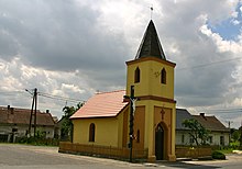
- Rochus Chapel with bell tower from 1861
- Memorial to the fallen of both world wars
- Stone path chapel made of brick
- Village pond
- Several wayside crosses
- Wayside shrines
- Miniature replica of a scrap wood windmill and millstone
societies
- German Friendship Circle
- Volunteer Fire Brigade OSP Pogórze
- Football club LUKS Polonia Pogórze
- Rural Women's Association Koło Gospodyń Wiejskich
Personalities
- Johannes Baptist Przyklenk (1916–1984), Catholic Bishop of Januária
Web links
Individual evidence
- ↑ Graport o stanie Gminy Biała za 2018 rok , accessed on June 2, 2020
- ↑ a b c History of Pogosch (Polish)
- ^ A b Felix Triest : Topographisches Handbuch von Oberschlesien , Breslau 1865, p. 1003
- ↑ a b Johann Georg Knie : Alphabetical-statistical-topographical overview of the villages, towns, cities and other places of the royal family. Preuss. Province of Silesia. Breslau 1845, p. 499.
- ↑ Territorial District Chrzelitz I / Wiesengrund
- ↑ AGoFF district Neustadt OS
- ↑ See results of the referendum in Upper Silesia of 1921 ( Memento of January 29, 2017 in the Internet Archive )
- ^ Michael Rademacher: German administrative history from the unification of the empire in 1871 to the reunification in 1990. neustadt_os.html. (Online material for the dissertation, Osnabrück 2006).


