Zülz
| Zülz Biała |
||
|---|---|---|

|
|
|
| Basic data | ||
| State : | Poland | |
| Voivodeship : | Opole | |
| Powiat : | Prudnicki | |
| Gmina : | Zülz | |
| Area : | 14.71 km² | |
| Geographic location : | 50 ° 22 ′ N , 17 ° 36 ′ E | |
| Height : | 220-250 m npm | |
| Residents : | 2412 (December 31, 2018) | |
| Postal code : | 48-210 | |
| Telephone code : | (+48) 77 | |
| License plate : | OPR | |
| Economy and Transport | ||
| Street : | Ext. 414 Prudnik - Opole | |
| Next international airport : | Wroclaw | |
| Katowice | ||
Zülz (Polish: Biała ) is a country town with around 2500 inhabitants in the powiat Prudnicki of the Polish Opole Voivodeship . It is the seat of the town-and-country municipality of the same name with around 10,700 inhabitants.
Zülz has officially been a bilingual community (German and Polish) since 2006.
geography

location
The rural town of Zülz is located in the south of the historical region of Upper Silesia on the Zülzer Wasser ( Biała ), about eight kilometers northeast of Prudnik ( Neustadt ) and about 40 kilometers southwest of Opole .
The city is located in the Nizina Śląska (Silesian Plain) within the Kotlina Raciborska (Ratibor Basin) to the Płaskowyż Głubczycki (Leobschützer Loesshügelland) .
Neighboring places
Neighboring towns of Zülz are Waschelwitz ( Wasiłowice ) in the north, Altzülz ( Solec ) in the east, Olbersdorf ( Olbrachcice ) in the southeast and Groß Pramsen ( Prężyna ) in the southwest .
history

In the south-west of their domain, the Dukes of Opole had built Bela Castle on the Zülzer Wasser , which was the seat of a castellan . Below the castle, a German parish village of Bela emerged as the starting point for further settlement of the forests on the border with Moravia , which can be traced for the first time in 1225. Other places were founded from Bela, such as Kostenthal (1225, today: Gościęcin) and Kasimir (1240, today: Kazimierz) near Oberglogau .
Around 1270, a town called Bela alias Czolz was founded with German law between the village and Bela Castle . Its complex was built around a market square, it was walled and had two city gates.
The city was soon referred to as Zolez and later Zülz , the name Alt Zülz (Solec) became established for the village of the same name, four kilometers to the east, and the village of Bela was called the old town . Its church became a branch church of the city church, which was newly built in 1400. Two chapels and parochial schools were built in the suburbs. In 1311 Zülz became the seat of a bailiff ; from 1335 onwards there was an Archipresbyterate in the little town that was owned by the Dukes of Opole . After the death of the last Piast Duke of Opole, Johann II , the city passed to the Habsburgs in their capacity as kings of Bohemia. They mortgaged the property. Among the various owners of the Zülz Chamber of Commerce, the Barons of Proskau, who from 1565 initially owned the city and from 1602 also the nine villages, acquired special significance. Since the end of the 14th century, numerous Jews had settled in the Neiss suburb in particular . Under the barons of Proskau, Zülz remained the only Silesian town besides Glogau from which the Jews were not expelled at the end of the 16th century. In 1601 Emperor Rudolf II granted the Zülz Jews a protection privilege at the request of the Lords of Proskau .
During the Thirty Years' War a plague epidemic broke out in the farming town , which in 1633 almost completely wiped out the population. A plague chapel was built to commemorate this. The trade privilege granted in 1699 allowed the Jews from Zülz to trade in Silesia , Bohemia and Poland , thereby gaining the same rights as Christian merchants. Because of these rights, there was a large influx of Jews into the city in the 18th century. The colloquial name Judenzülz for the city comes from this period , while the Jewish residents also used the Hebrew name Makom Zadik (place of the righteous).
When Silesia was partitioned in the preliminary peace of Breslau , Zülz fell to Prussia in 1742 . As a result of Friedrich Wilhelm III. On March 11, 1812, as part of the Prussian reforms , the Edict of Emancipation, which officially abolished the exclusion of Jews in Prussia and also allowed them to settle elsewhere as free merchants, most Jews soon left the town and moved to the big cities. This emigration was so strong that in 1914 the Jewish community in Zülz decided to dissolve it.
In 1727 the barons of Proskau rebuilt the 16th century castle with its architecturally valuable cloister. In 1748 Bartolomäus von Oderfeld became the new owner of the Zülz Chamber of Commerce, followed by Count Matuschka in 1756 , until the division of rule began in 1841. The city then bought the castle, which was used as a preparation institute between 1874 and 1923 and as a teacher training seminar from 1875 to 1925. From 1926 to 1934 it housed a girls' school, and since its closure the building has been used as a municipal high school.
On October 22, 1896, Zülz, which had belonged to the Neustadt OS district since 1816, was connected to the railway network from Neustadt with the opening of the 11 km long first section of the Neustadt-Gogoliner Railway Company. On December 4, 1896, the construction of the 31 km long second section of the railway, which led from Zülz to Gogolin in the northeast , was completed. At the beginning of the 20th century, Zülz had a Protestant church, a Catholic church, a Catholic school teachers' seminar housed in the former castle with a preparation facility, a sugar factory (in the neighboring village of Schönowitz), a machine factory, a brick factory and clay and cement pipe production.
In the referendum in Upper Silesia in 1921 after the First World War , which was supposed to decide on the further state affiliation of the region, Zülz was outside the voting area, which included only the eastern part of the Neustadt OS district.
Towards the end of the Second World War , Zülz was occupied by the Red Army on March 18, 1945 . After the end of the war, the region was placed under Polish administration by the Soviet Union . The German city has now been renamed Biała . Then began the immigration of Polish migrants, some of them from areas east of the Curzon Line , where they belonged to the Polish minority. Although a large part of the German population was expelled by the local Polish administrative authority in the following years, a considerable German minority was able to survive in the municipality of Zülz.
The municipality has been officially bilingual since 2006, and in 2008 it introduced bilingual place names. The currently incumbent mayor belongs to the German minority.
In 1991, passenger traffic on the Prudnik - Krapkowice railway was discontinued and in 1992 the line was completely closed.
Demographics
| year | population | Remarks |
|---|---|---|
| 1780 | 2036 | of which 1035 Christians and 1001 Jews |
| 1781 | 2061 | including 1035 Christians and 1024 Jews |
| 1782 | 2022 | 961 Christians and 1,061 Jews thereof |
| 1816 | 2377 | |
| 1825 | 2462 | thereof 34 Evangelicals, 1319 Catholics, 1109 Jews |
| 1840 | 2657 | 66 Protestants, 1836 Catholics, 755 Jews |
| 1855 | 2620 | |
| 1861 | 2700 | 126 Evangelicals, 2235 Catholics, 339 Jews; |
| 1867 | 2626 | on December 3rd |
| 1871 | 2613 | including 100 Protestants, 360 Jews (450 Poles ); According to other data, 2780 inhabitants (on December 1), including 86 Evangelicals, 2446 Catholics, 238 Jews |
| 1905 | 2816 | mostly Catholics |
| 1910 | 2842 | on December 1st |
| 1933 | 3744 | |
| 1939 | 3784 |
| year | Residents |
|---|---|
| 1961 | 2,832 |
| 1971 | 3,100 |
| 1980 | 2,900 |
| 1995 | 2,909 |
| 2000 | 2,831 |
| 2005 | 2,679 |
Attractions
Church of the Assumption of Mary
The Roman Catholic Church of the Assumption of the Virgin Mary (Polish: Kościół Wniebowzięcia Najświętszej Maryi Panny ) is located on the northwest corner of the ring. The building dates mainly from the 16th century. The interior of the church is in the baroque style.
St. Peter and Paul Church
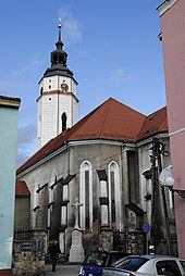
The Roman Catholic St. Peter and Paul Church (Polish. Kościół św. Piotra i św. Pawła ) is located in the so-called Zülz old town, southeast of today's city center. The church was probably built in. Century. After a fire, the church was expanded and redesigned in 1690. The nave has a rectangular floor plan. On the west side is the three-storey bell tower on a rectangular floor plan and an octagonal end. The tower is covered with a bent pointed helmet. The baroque main altar was erected in the second half of the 17th century. He owns a painting of the Holy Trinity from 1700. The church building has been a listed building since 1964.
Zülz Castle
Zülz Castle was first mentioned in 1225 as a Kastellaneiburg. The building is located in the northern part of the historic city center along the northern city wall. The core of the current building dates from the 15th century. The building was rebuilt and expanded in the 17th and 18th centuries. The building is located on an F-shaped floor plan, has two floors with a gable roof and a volute gable. The west tower on a square floor plan with a tail hood was built in the 18th century. From 1878 the building was used as a school. Later the building was used to house a teachers' college and the municipal high school. Between 1946 and 1980 the local elementary school was located in the castle. The building has been used commercially since 1987. The castle has been a listed building since 1959.
Water tower
The Zülzer water tower is located northeast of the city center at the foot of the castle hill. The tower was built in 1606. The building was renovated between 1958 and 1959. The three-story building has a square floor plan and consists of plastered brick. The building has been a listed building since 1959.
More Attractions
- Neustadt defense tower
- Jewish Cemetery
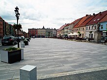
- Ring with baroque, classicist and socialist houses
- Nepomuk statue
- Fragments of the city wall
- Former Evangelical Church
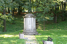
- Memorial to the fallen of the First World War
politics
coat of arms
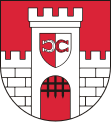
Zülz coat of arms: In red, a silver castle with a tin tower and drawn portcullis . A shield on the tower is split from red and silver and has a lying horseshoe with the horseshoe arch butting against the shield division in mixed up colors .
symbolism
The shield shows the coat of arms of the Proskowski von Proskau family . The city coat of arms appears in this form in a seal from 1693. Due to numerous city fires, no older documents have survived. According to Hugo Saurma, Emperor Ferdinand I of the city in the first year of the reign Proskauschen 1564 this coat of arms, which, however, only one multiplication is the old coat of arms to the shield of the new owners.
Twin cities
- Marienheide , North Rhine-Westphalia, Germany
- Město Albrechtice , Czech Republic
- Vlčice , Okres Jeseník, Czech Republic
local community
The city-and-country community of Zülz covers an area of 195.82 km², with around 10,700 inhabitants. It is divided into 29 villages with school boards.
Personalities
sons and daughters of the town
- Adolph Martin Schlesinger (1769–1838), music publisher and music dealer
- Julius Landsberger (1819–1890), orientalist and rabbi
- Louis Loewe (1809-1888), orientalist
- Salomon Cohn (1822–1902), rabbi
- Johann Hoeniger (1850–1913), architect
- Rudolf Tunkel (1898 – after 1932), politician
- Harry Thürk (1927–2005), writer
- Heinz Branitzki (1929–2016), industry manager
Personalities who have worked on site
- Josef Hirsch Janow (1733–1785), rabbi, temporarily rabbi in Zülz
- Zvi Zamoscz (1740–1807), rabbi, Kabbalist and teacher, occasionally a teacher in Zülz
- Anton Frenzel (1790–1873), Catholic theologian, vicar general and auxiliary bishop, 1818–1820 chaplain in Zülz
- Johannes Reinelt (1858–1906), writer and Silesian dialect poet, attended the educational seminar in Zülz
- Franz Volkmer (1846–1930), pedagogue, didactic and local researcher, director of the teachers' college in Zülz
- Andrea Rischka (* 1991), singer, musician and politician, lives in Zülz
traffic
State road 414 runs east of the historic town center in a north-south direction .
The place is located on the Neustadt-Gogoliner Eisenbahn line, which has been closed for passenger traffic .
literature
- Felix Triest : Topographical Handbook of Upper Silesia , Wilh. Gottl. Korn, Breslau 1865, pp. 1086-1091 .
- Johannes Chrząszcz : History of Zülz. (Reprint from the magazine Oberschlesische Heimat) (djvu file)
- Johannes Chrząszcz: History of the city of Zülz in Upper Silesia; from the oldest times to the present. (Co-authors: Hanke, Israel Rabin; Editor: Magistrat Zülz, 1926)
- Bibliography on the history of Zülz at LitDok East Central Europe / Herder Institute (Marburg)
Web links
- Official website of the city and community of Zülz
- City view in the travel album of Count Palatine Ottheinrich 1536/37
Individual evidence
- ↑ Graport o stanie Gminy Biała za 2018 rok , accessed on June 11, 2020
- ↑ a b Meyer's Large Conversation Lexicon . 6th edition, Volume 20, Leipzig / Vienna 1909, p. 1012 .
- ↑ a b c Friedrich Gottlob Leonhardi : Earth Description of the Prussian Monarchy , Volume 3, Part 1, Halle 1792, pp. 92-94 .
- ↑ Alexander August Mützell and Leopold Krug : New topographical-statistical-geographical dictionary of the Prussian state . Volume 5, T – Z , Halle 1823, p. 242, item 1303 .
- ↑ Johann Georg Knie : Alphabetical-statistical-topographical overview of the villages, spots, cities and other places of the royal family. Prussia. Province of Silesia, including the Margraviate of Upper Lusatia, which now belongs entirely to the province, and the County of Glatz; together with the attached evidence of the division of the country into the various branches of civil administration. Melcher, Breslau 1830, p. 1046 .
- ^ Johann Georg Knie : Alphabetical-statistical-topographical overview of the villages, spots, cities and other places of the royal family. Preusz. Province of Silesia. 2nd Edition. Graß, Barth and Comp., Breslau 1845, pp. 954-955 .
- ↑ a b Felix Triest : Topographisches Handbuch von Oberschlesien , Wilh. Gottl. Korn, Breslau 1865, p. 1041, paragraph 71
- ^ A b Royal Statistical Bureau: The municipalities and manor districts of the Province of Silesia and their population. Based on the original materials of the general census of December 1, 1871. Berlin 1874, pp. 382–383, item 3 .
- ^ Gustav Neumann : The German Empire in geographical, statistical and topographical relation . Volume 2, GFO Müller, Berlin 1874, pp. 182-183, item 14 .
- ^ Kingdom of Prussia - Province of Silesia - District of Opole - District of Neustadt (Upper Silesia). In: Gemeindeververzeichnis.de. Retrieved August 1, 2020 .
- ↑ a b M. Rademacher: German administrative history from the unification of the empire in 1871 to the reunification in 1990. (Online material for the dissertation, Osnabrück 2006)
- ↑ Sources of population figures : - 1971: Heinz Rudolf Fritsche: Schlesien Wegweiser. Bechtermünz Verlag, Augsburg 1996 - 1980: Encyklopedia Powszechna PWN - 1995, 2000, 2005: Link ( Memento from February 16, 2008 in the Internet Archive )
- ↑ a b c Dehio Handbook of Art Monuments in Poland. Silesia. Deutscher Kunstverlag, Munich et al. 2005, ISBN 3-422-03109-X , pp. 120–121.
- ↑ a b c List of monuments in the Opole Voivodeship (woj. Opolskie - pow. Brzeski). In: nid.pl. Retrieved in 2020 (Polish).
- ↑ Cf. Hugo Saurma, Hrsg .: Wappenbuch der Silesian cities and towns. Berlin 1870


