Guarayos Province
| Guarayos Province | |
|---|---|
 |
|
| Basic data | |
| Country | Bolivia |
| Department | Santa Cruz |
| Seat | Ascención de Guarayos |
| surface | 20,293 km² |
| Residents | 48,301 (2012) |
| density | 2.4 inhabitants per km² |
| ISO 3166-2 | BO-S |
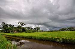
| Rice cultivation in the province of Guarayos | |
Coordinates: 15 ° 20 ′ S , 63 ° 30 ′ W
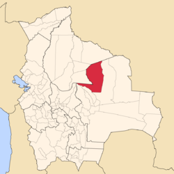
Guarayos is a province in the northwestern part of the Santa Cruz department in the lowlands of the South American Andean state of Bolivia .
location
The province is one of fifteen provinces in the Santa Cruz Department. It borders in the north and northwest with the Beni department , in the southwest with the province of Ichilo and the province of Obispo Santistevan , and in the south and east with the province of Ñuflo de Chávez .
It extends between 13 ° 58 'and 16 ° 30' south latitude and 62 ° 29 'and 64 ° 44' west longitude, its east-west extent is up to 320 kilometers, its north-south extent about 380 kilometers.
population
The population of Guarayos Province has almost tripled in the past two decades:
- 1992 : 17,697 inhabitants ( census )
- 2001 : 31,577 inhabitants (census)
- 2012 : 48,301 inhabitants (census)
Parts of the province are inhabited by Guarayos people who have settled here since the end of the 16th century.
structure
The province of Guarayos was divided into the following three districts ( Bolivian : Municipios ) at the last census of 2012 :
- 07-1501 Municipio Ascención de Guarayos - 27,070 inhabitants
- 07-1502 Municipio Urubichá - 7,026 inhabitants
- 07-1503 Municipio El Puente - 14,205 inhabitants
Individual evidence
- ^ Instituto Nacional de Estadística Bolivia (INE) 1992
- ↑ Instituto Nacional de Estadística Bolivia (INE) 2001
- ↑ Instituto Nacional de Estadística Bolivia (INE) 2012
Web links
- Santa Cruz Department - Social data (PDF 5.12 MB) ( Spanish )
- Municipio Ascención de Guarayos - detailed map and population data (PDF; 1.85 MB) ( Spanish )
- Municipio El Puente - detailed map and population data (PDF; 1.52 MB) ( Spanish )
- Municipio Urubichá - detailed map and population data (PDF; 1.52 MB) ( Spanish )
