
Rancon
| Rancon | ||
|---|---|---|
.svg)
|
|
|
| region | Nouvelle-Aquitaine | |
| Department | Haute-Vienne | |
| Arrondissement | Bellac | |
| Canton | Châteauponsac | |
| Community association | Gartempe Saint-Pardoux | |
| Coordinates | 46 ° 8 ′ N , 1 ° 11 ′ E | |
| height | 185-337 m | |
| surface | 32.31 km 2 | |
| Residents | 494 (January 1, 2017) | |
| Population density | 15 inhabitants / km 2 | |
| Post Code | 87290 | |
| INSEE code | 87121 | |
 Saint-Pierre-ès-Liens church |
||

Rancon is a French municipality with 494 inhabitants (as of January 1 2017) in the region Nouvelle-Aquitaine , in the department of Haute-Vienne , in district Bellac and in Canton Châteauponsac . It is bordered by Droux to the northwest , Villefavard to the northeast, Châteauponsac to the east, Balledent to the southeast, Saint-Pardoux-le-Lac with Roussac to the south, Saint-Junien-les-Combes to the southwest and Blanzac to the west . The residents call themselves ranconniers .
Population development
| year | 1962 | 1968 | 1975 | 1982 | 1990 | 1999 | 2008 | 2013 |
|---|---|---|---|---|---|---|---|---|
| Residents | 911 | 860 | 733 | 652 | 544 | 519 | 542 | 522 |
Attractions
- Saint-Pierre-ès-Liens church
- War memorial, Monument historique
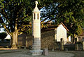
War memorial

Railway viaduct above the Gartempe . The narrow-gauge railway line was in operation between 1911 and the time of the First World War.


Web links
Commons : Rancon - collection of images, videos and audio files