Rettwitz
|
Rettwitz
City of Blankenhain
Coordinates: 50 ° 49 ′ 55 ″ N , 11 ° 18 ′ 12 ″ E
|
|
|---|---|
| Height : | 422 m |
| Residents : | 46 (Aug 2019) |
| Incorporation : | May 6, 1984 |
| Incorporated into: | Krakendorf |
| Postal code : | 99444 |
| Area code : | 036459 |
Rettwitz is a district of the town of Blankenhain in the Weimarer Land district , Thuringia .
geography
The place Rettwitz lies behind a wooded area south of Krakendorf . The main road in 1060 leads north past behind octopus village. It can be reached via a local road. The neighboring villages of Treppendorf and Haufeld are located south of Rettwitz . They lie like Rettwitz on a trough-like plateau with wooded mountains made of shell limestone . These places are located on the edge of the Thuringian Basin on locations that are mostly remote from groundwater. To the east, federal highway 85 leads south from Blankenhain to Rudolstadt .
The "Goethe Valley circular hiking trail" leads through Rettwitz.
history
The place was first mentioned in a document on December 27, 1199. The place is a Slavic settlement and an agricultural village with former middle-class structures.
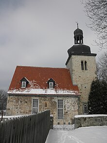
The church bears the year 1592, but is said to have been built in the 12th century. The children used to go to school in Krakendorf .
See also
Individual evidence
- ↑ Krakendorf / Rettwitz on blankenhain.de, accessed on June 10, 2020.
- ^ Wolfgang Kahl : First mention of Thuringian towns and villages. A manual. 5th, improved and considerably enlarged edition. Rockstuhl, Bad Langensalza 2010, ISBN 978-3-86777-202-0 , p. 232.
- ↑ Rettwitz on a private website on Blankenhain. Retrieved September 20, 2011.
