Meckfeld (Blankenhain)
|
Meckfeld
City of Blankenhain
Coordinates: 50 ° 51 ′ 4 " N , 11 ° 26 ′ 16" E
|
|
|---|---|
| Height : | 399 m above sea level NN |
| Residents : | 31 (Sep 2011) |
| Incorporation : | March 1, 1974 |
| Incorporated into: | Keßlar |
| Postal code : | 99444 |
| Area code : | 036459 |
|
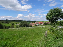
Meckfeld from the east
|
|
Meckfeld is a district of the city of Blankenhain in the Weimarer Land district , Thuringia .
geography
The hamlet-like place is 6.5 kilometers from Blankenhain on the border with the Saale-Holzland district near Milda . The county road 308 connects the village with the main road in 1060 of Apolda Blankenhain and Rudolstadt . The demarcation lies in a docked hollow of a plateau on shell limestone . These soils are mostly remote from the groundwater. In the southern area there is forest on the hills near Reinstädt .
history
The first documentary mention of the village was registered in 1350. The village first belonged to Orlamünde-Lauenstein . The ownership often changed. In 1784 a major fire raged in the village. Agriculture was the main livelihood with a medium-sized farm structure. In 1884 the areas were separated. Later the farmers switched to beekeeping . After the reunification they found new forms according to the conditions in East Germany.
See also
Individual evidence
- ^ Wolfgang Kahl : First mention of Thuringian towns and villages. A manual. 5th, improved and considerably enlarged edition. Rockstuhl, Bad Langensalza 2010, ISBN 978-3-86777-202-0 , p. 177.

