
Reundorf (Lichtenfels)
|
Reundorf
City of Lichtenfels
Coordinates: 50 ° 7 ′ 55 ″ N , 11 ° 1 ′ 36 ″ E
|
||
|---|---|---|
| Height : | 260 m above sea level NN | |
| Residents : | 591 (Feb. 8, 2016) | |
| Incorporation : | May 1, 1978 | |
| Postal code : | 96215 | |
Location of Reundorf in Bavaria |
||

Reundorf is a district of the Bavarian district town Lichtenfels with 591 inhabitants (as of 2016).
The church village is located directly on the federal motorway 73, which runs to the east .

Christ the King Church
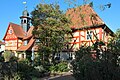
Half-timbered house on Christ-König-Platz
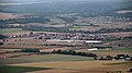
Reundorf seen from the Staffelberg


history
"Rannendorf" was first mentioned in 1142 in a document.
Until the end of the Old Kingdom , the place belonged partly to the cathedral chapter of Bamberg and partly to the Banz monastery .
In 1818 Reundorf, which until then had belonged to the Schönbrunn community, became an independent community. In 1818 Reundorf had 129 inhabitants, in 1950 there were 252, 1961 237 and in 1970 240. On May 1, 1978 it was incorporated into the town of Lichtenfels.
Culture and sights
- Catholic Church of Christ the King
In the list of architectural monuments in Lichtenfels (Upper Franconia) , four architectural monuments are identified for Reundorf .
Regular events
- Parish fair on the last Sunday in June
Web links
- Reundorf on the website of the city of Lichtenfels
- Reundorf in the location database of the Bayerische Landesbibliothek Online . Bavarian State Library
Individual evidence
- ↑ Reundorf. City of Lichtenfels, accessed on July 10, 2017 .
- ^ Federal Statistical Office (ed.): Historical municipality directory for the Federal Republic of Germany. Name, border and key number changes in municipalities, counties and administrative districts from May 27, 1970 to December 31, 1982 . W. Kohlhammer GmbH, Stuttgart / Mainz 1983, ISBN 3-17-003263-1 , p. 695 .

Book at the forest | Degendorf | Eichig | Gnellenroth | Hammer | Isling | Klosterlangheim | Kösten | Köttel | Krappenroth | Lame | Mistletoe field | Mönchkröttendorf | Oberlangheim | Oberwallenstadt | Reundorf | Roth | Rothmannsthal | Schney | Schönsreuth | Seehof | Seubelsdorf | Stetten | Sticks | Tiefenroth | Shoot | Unterwallenstadt | Vineyard