South Kazakhstan

from Wikipedia, the free encyclopedia
South Kazakhstan
Region Оңтүстік Қазақстан облысы
Южно-Казахстанская область
coat of arms
coat of arms
Basic data
State : KazakhstanKazakhstan Kazakhstan
Administrative headquarters : Schymkent
 
Area : 117,249  km²
Residents : Invalid metadata key{{{KATO-Code}}} [[Category: Wikipedia: Error in template metadata population # Invalid metadata key {{{KATO code}}}]] (Jan. 1, 2020)
Population density : Error in expression: Unexpected operator < inhabitants per km²
 
Time zone :
Postal code :
Telephone code : +7 (725)
License plate :
ISO 3166-2 : KZ-KZ-YUZ
 
Äkim ( governor ) : Shanseyit Tuimebayev
Website :
Location in Kazakhstan
Turkmenistan Usbekistan Aserbaidschan Georgien Kirgisistan Tadschikistan China Russland Baikonur Almaty Nur-Sultan Mangghystau Atyrau Westkasachstan Aqtöbe Qostanai Nordkasachstan Aqmola (Gebiet) Pawlodar Qaraghandy Qysylorda Türkistan Schambyl Ostkasachstan Almatymap
About this picture

The region South Kazakhstan ( Kazakh Оңтүстік Қазақстан облысы Ongtüstik Qasaqstan oblyssy ; Russian Южно-Казахстанская область Yuzhno Kasachstanskaja oblast ) was associated with a population of about 2.84 million inhabitants, is the southernmost Oblys ( area ) of Kazakhstan . The capital was Shymkent . On June 19, 2018, Schymkent was spun off and raised to a city with special status. The remaining area was renamed after the new capital in Turkistan .

geography

With an area of ​​around 117,249 km², southern Kazakhstan was the second smallest of the 14 regions in Kazakhstan. However, it was the most populous and at the same time the most densely populated oblys.

The South Kazakhstan Oblast was formed in 1932 in the Kazakh SSR of the Soviet Union . From 1962 to 1992 it was called Chimkent, after the capital Oblast .

The population increased from 1.8 million in 1989 to 2.6 million in 2011. The province's population consists of almost 70% Kazakhs , while Uzbeks (17.5%) and Russians (6%) are significant minorities . Other groups, such as Azerbaijanis , Tajiks , Soviet Koreans , Tatars , Ukrainians or Russian- Germans together make up a little more than 6% of the population.

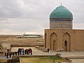
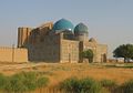
The capital and at the same time the largest city of the province was Schymkent with about 643,000 inhabitants, a university town and an important business location. Other larger cities in southern Kazakhstan were Türkistan , Lenger and Schetissai . In the south, southern Kazakhstan bordered directly on neighboring Uzbekistan and Kyrgyzstan . The Uzbek capital Tashkent was right on the border with southern Kazakhstan. The province also bordered three other provinces of Kazakhstan: Karagandy , Qysylorda, and Shambyl .

The Syr Darja flowed through the province on its way to the Aral Sea . An oil pipeline also ran through southern Kazakhstan from Türkmenabat ( Turkmenistan ) to Omsk in Russia , where it connected to a larger, Siberian pipeline. In Schymkent, oil , lead and zinc were refined. In South Kazakhstan is also some significant cultural sites and testimonies found ancient Islamic architecture , such as the as UNESCO World Heritage Site in force mausoleum of Hodja Ahmad Yasawi in the city of Turkestan.

population

Ethnic groups

Ethnic group VZ 1989 VZ 1999 VZ 2009
number % number % number %
Kazakhs 1,017,470 55.80% 1,340,889 67.78% 1,785,992 72.33%
Uzbeks 285.042 15.63% 332.202 16.79% 401.630 16.26%
Russians 278.473 15.27% 162,098 8.19% 136,538 5.52%
Tajiks 19,593 1.07% 21,370 1.08% 29,742 1.20%
Azerbaijanis 27,049 1.48% 24,732 1.25% 28,956 1.17%
Turks 11.051 0.61% 18,665 0.94% 20,995 0.85%
Tatars 34,615 1.90% 23,672 1.20% 19,119 0.77%
Korean 11,430 0.63% 9780 0.49% 9717 0.40%
Kurds 6306 0.35% 6661 0.34% 8399 0.34%
Ukrainians 33,033 1.81% 13,039 0.66% 7948 0.33%
Other 99,466 5.45% 25,231 1.28% 20,321 0.82%
total 1,823,528 100% 1,978,339 100% 2,469,357 100%

Population development

The population of the South Kazakhstan area was around 2.84 million as of January 1, 2016, making it the first in Kazakhstan in terms of population. The population has grown steadily since the 1970s, reaching two million for the first time in the early 2000s. With a population density of 24.2 inhabitants per km², southern Kazakhstan was also by far the most densely populated area in Kazakhstan.

year Residents
1970 1,287,431
1979 1,566,794
1989 1,831,486
1999 1,978,339
2003 2,111,893
2004 2,150,256
2005 2,193,556
2006 2,233,568
2007 2,282,474
year Residents
2008 2,331,505
2009 2,462,782
2010 2,511,698
2011 2,567,707
2012 2,621,488
2013 2,678,889
2014 2,733,279
2015 2,788,404
2016 2,840,557

Administrative division

The area was divided into 11 districts (kazach. Ауданы / Audany ) and 4 independent cities. Other cities in the South Kazakhstan area were Lenger , Saryaghasch , Schardara and Schetissai .

South Kazakhstan (South Kazakhstan)
Arys
Arys
Kentau
Kentau
Lenger
Lenger
Saryaghash
Saryaghash
Shardara
Shardara
Shetissai
Shetissai
Schymkent
Schymkent
Turkistan
Turkistan
Audany Area [km²] Residents Administrative headquarters
Boidibek 7,200 55.292 Shayan
Maqtaaral 1,800 305.738 Shetissai
Ordabassy 2,700 117,581 Temirlan
Otyrar 18,100 54,260 Schäuildir
Qasyghurt 4,100 109.031 Qasyghurt
Sayram 1760 198.981 Aqsu
Saryaghash 7,613 321,842 Saryaghash
Shardara 13,000 79,345 Shardara
Sosaq 41,000 60,851 Scholaqqorghan
Oil Bi 3,100 116,813 Lenger
Tulkibas 2,300 110.265 Turar Rysqulov
Residents as of 2016; Source (rus.)
District-free city Area [km²] Residents
Arys 73,827
Kentau 94.171
Schymkent 1170 886.349
Turkistan 7,400 256.961
Residents as of 2016; Source (rus.)

politics

List of governors ( Kazakh Әкім , Äkim ) of the South Kazakhstan region since 1992:

No. Surname Term of office (beginning) Term of office (end)
1 Mars Urkimbayev 1992 December 1993
2 Sauytbek Turysbekow December 1993 December 1997
3 Qalyq Abdullaev December 1997 July 1999
4th Berdibek Saparbayev July 1999 August 31, 2002
5 Bolat Shylqyshev August 31, 2002 September 2006
6th Ömirsaq Schökeev September 2006 August 28, 2007
7th Nurghali Aeschim August 28, 2007 March 4, 2009
8th Asqar Myrzachmetov March 4, 2009 August 8, 2015
9 Beibit Atamqulow August 8, 2015 October 7, 2016
10 Shanseyit Tuimebayev October 7, 2016 19th June 2018

gallery

Web links

Commons : South Kazakhstan  - Collection of pictures, videos and audio files

Individual evidence

  1. Численность населения Республики Казахстан по полу в разрезе областей и столицы, столицы, столицы, анколицы, столицы, городоав, областей и столицы, анкония, горойцы, коники, городоав,. ( Excel ; 96 KB) stat.gov.kz, accessed on July 19, 2020 (Russian).
  2. Публичное подписание Указа «О некоторых вопросах административно-территориальсаного услейстах 2018
  3. pop-stat.mashke.org: Ethnic composition: 1989 census (data for regions) , accessed June 24, 2017 (Russian).
  4. pop-stat.mashke.org: Ethnic composition: 1999 census (data for regions) , accessed June 24, 2017 (Russian).
  5. pop-stat.mashke.org: Ethnic composition: 2009 census , accessed June 24, 2017 (Russian).


Coordinates: 43 ° 0 ′ 0 ″  N , 68 ° 30 ′ 0 ″  E