San Vicente de Chucurí
| San Vicente de Chucurí | ||
|---|---|---|
|
Coordinates: 6 ° 53 ′ N , 73 ° 25 ′ W San Vicente de Chucurí on the map of Colombia
|
||
|
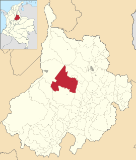
Location of the municipality of San Vicente de Chucurí on the map of Santander
|
||
| Basic data | ||
| Country | Colombia | |
| Department | Santander | |
| City foundation | 1867 | |
| Residents | 35,121 (2019) | |
| City insignia | ||
| Detailed data | ||
| surface | 1195 km 2 | |
| Population density | 29 people / km 2 | |
| height | 693 m | |
| Time zone | UTC -5 | |
| City Presidency | Omar Acevedo Ramírez (2016-2019) | |
| Website | ||
| San Vicente de Chucurí | ||
San Vicente de Chucurí is a municipality (municipio) in the department of Santander in Colombia .
geography
San Vicente de Chucurí is located in the province of Mares in Santander at an altitude of 693 meters about 94 km from Bucaramanga . The municipality borders Betulia in the north , Barrancabermeja in the west , El Carmen de Chucurí in the south and Zapatoca and Galán in the east .
population
The municipality of San Vicente de Chucurí has 35,121 inhabitants, of which 13,864 live in the urban part (cabecera municipal) of the municipality (as of 2019).
history
The city was founded in 1867 under the name Angostura . In 1887, San Vicente de Chucurí was appointed a municipality. Its growth and development matched that of most Colombian villages after liberation from the Spanish conquerors in the Colombian Revolution. The development followed the creation of a church as a center of power, a center of faith and a meeting place, around which the new settlers of the country built houses.
Outstanding components of this development process in San Vicente de Chucurí are:
1878 Foundation of the first church of San Vicente Ferrer.
1908 arrival of the telegraph .
1916 arrival of the telephone .
1925 Construction of the aqueduct and the electrical system.
1932 Construction of the road to Barrancabermeja is completed.
1985 El Carmen de Chucurí is split off from San Vicente and recognized as a municipality.
economy
The main industry is agriculture .
cocoa
In San Vicente de Chucurí, cocoa is grown in particular , which is why the city bears the unofficial title of Capital Cacaotera de Colombia (Cocoa Capital of Colombia). San Vicente de Chucuri is the largest cocoa producer in the Santander department and the largest producer in Colombia. This product accounts for 60% of the total agricultural production that is achieved in the municipality (7,000 tons annually).
The most important growing areas are: Llana Fría, Santa Inés, La Esmeralda, Campo Hermoso, Mérida, El Centro, Palestina, Nuevo Mundo, Guadual, El León, Ceibal, Aguablanca, El Pertrecho and La Esperanza.
avocado
The San Vicente de Chucurí avocado is known nationally and is famous for its taste and quality. After cocoa, it is the community’s main product, producing 200 tons per year. The most important growing areas are Santa Rosa, Primavera, El Ceibal, León and Llana Fría.
There is also oil , natural gas and coal production as well as cattle production .
Web links
- Página Oficial del Municipio de San Vicente de Chucurí. Alcaldía del Municipio de San Vicente de Chucurí - Santander, accessed April 17, 2019 (Spanish, website of the municipality).
- www.sanvicentedechucuri.com
Individual evidence
- ↑ a b c Nuestro municipio. Alcaldía del Municipio de San Vicente de Chucurí - Santander, accessed April 17, 2019 (Spanish, information on the municipality).
- ↑ ESTIMACIONES DE POBLACIÓN 1985 - 2005 Y PROYECCIONES DE POBLACIÓN 2005 - 2020 TOTAL DEPARTAMENTAL POR ÁREA. (Excel; 1.72 MB) DANE, May 11, 2011, accessed on April 17, 2019 (Spanish, extrapolation of the population of Colombia).


