
Sielenbach
| coat of arms | Germany map | |
|---|---|---|

|
Coordinates: 48 ° 24 ' N , 11 ° 10' E |
|
| Basic data | ||
| State : | Bavaria | |
| Administrative region : | Swabia | |
| County : | Aichach-Friedberg | |
| Management Community : | Dasing | |
| Height : | 470 m above sea level NHN | |
| Area : | 17.84 km 2 | |
| Residents: | 1732 (Dec. 31, 2019) | |
| Population density : | 97 inhabitants per km 2 | |
| Postal code : | 86577 | |
| Area code : | 08258 | |
| License plate : | AIC, FDB | |
| Community key : | 09 7 71 165 | |
| LOCODE : | DE ZSI | |
| Community structure: | 12 parts of the community | |
| Association administration address: | Kirchstrasse 7 86453 Dasing |
|
| Website : | ||
| Mayor : | Heinz Geiling (Sielenbach unit) | |
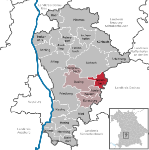
| Location of the municipality of Sielenbach in the Aichach-Friedberg district | ||
  |
||

Sielenbach is a municipality in the Swabian district of Aichach-Friedberg and a member of the Dasing administrative community .


geography
location
The place is located in the valley of the Ecknach in the middle of a tertiary hilly landscape about seven kilometers southeast of the district town of Aichach . It is located on State Road 2338, the connection from Aichach to the A 8 Munich – Stuttgart motorway .
Community structure
The municipality has 12 officially named municipal parts (the type of settlement is indicated in brackets ):
|
history
A farm in the Tödtenried district with finds typical of brick kilns is dated to Roman times.
In the 12th century still referred to as Sielepach, Suolempach and Syelenpach, the place name Sielenbach can be found as early as 1241. The forms Sylenpach and Siellepach appear later. In the 11th and 12th centuries, the Altomünster monastery owned several farms in Sielenbach, and the von Weichs owned property in Sielenbach from 1518. In 1611 the Commander of the Teutonic Order House in Blumenthal acquired the property of the Vistas. The old Stunzberg Castle was destroyed by Swedish troops in the Thirty Years' War in 1632 . In the course of secularization , the German House of Blumenthal was dissolved in 1803. The right to present the parish came to Bavaria and Sielenbach became an independent parish. From the legend about a miraculous image in a hollow pear tree, the pilgrimage church Maria Birnbaum was built from 1661 to 1668 , whose pastoral care was initially cared for by the Teutonic Order and then by Capuchins in the 19th and 20th centuries . The Teutonic Order has been active in Maria Birnbaum again since 1998 , renovating the monastery building and revitalizing the pilgrimage. The community of Sielenbach is now the longest street village in the Aichach-Friedberg district. The districts of Schafhausen, Raderstetten and the desert areas of Gollenhof and Schönberg have always belonged to the community of Sielenbach.
Incorporations
During the regional reform , which came into force on January 1, 1978, the neighboring village of Tödtenried with its districts Haslach and Schrötenloh was incorporated into Sielenbach.
Population development
Between 1988 and 2019 the municipality grew from 1,246 to 1,732 by 486 inhabitants or 39.0%.
politics
mayor
The new mayor from May 1, 2020 is Heinz Geiling (Sielenbach unit); he was elected with 70.2% of the vote. His predecessor Martin Echter led the congregation from May 2002 to April 2020.
Municipal council
The local council consists of the 1st mayor and twelve local councilors. The municipal council mandates from 2014 to 2020 were distributed as follows:
| Parties | 2014 | |
|---|---|---|
| proportion of | Seats | |
| Sielenbach unit (EHS) | % | 8th |
| Free voter community Tödtenried (FWT) | % | 4th |
For the term of office from May 1, 2020 to April 30, 2026, the following were elected on March 15, 2020 :
| Parties | 2020 | |
|---|---|---|
| proportion of | Seats | |
| Sielenbach unit (EHS) | 70.2% | 8th |
| Free voter community Tödtenried (FWT) | 29.8% | 4th |
coat of arms
The coat of arms description reads: Divided by silver, yellow and blue; above a continuous black paw cross on which a golden lily is placed, below a left silver side rafter.
Attractions

The baroque pilgrimage church of Maria Birnbaum is known far beyond the municipality's borders . It was built between 1661 and 1668 by order of Philipp Jakob von Kaltenthal , the Commander of the Teutonic Order in the neighboring town of Blumenthal, under the direction of Constantin Pader .
Economy and Infrastructure
Jobs
In 2013 there were a total of 164 employees subject to social security contributions at the workplace. There were a total of 672 employees who were subject to social security contributions and resided in Sielenbach. This meant that the municipality had 508 more outbound than inbound commuters.
Agriculture
In 2010 there were 39 farms. 1266 hectares (71.0%) of the municipal area were used for agriculture in 2013, 275 hectares (15.4%) were forest. The settlement area was 183 hectares (10.3%).
education
In 2014 there were two day-care centers with 65 places and 63 children. There was also an elementary school with 99 children.
Power generation
There are numerous energy generation systems for renewable energies in the municipality of Sielenbach. 2 wind turbines, 7 biomass systems, two small hydropower systems and 190 photovoltaic systems generate around 31,500 MWh of electricity per year (as of December 31, 2017). Electricity generation thus makes an important contribution to the energy transition in Bavaria and to the economic power of the community.
Partner communities
- Saint-Fraimbault-de-Prières (since 1992)
literature
- Wilhelm Liebhart, Michael Ritter (Ed.) Municipality of Sielenbach. Past and present . EOS Verlag, Sankt Ottilien 2020, ISBN 978-3-8306-7998-1
Web links
- Sielenbach (municipality) in the location database of the Bavarian State Library Online . Bavarian State Library
- Entry on Sielenbach's coat of arms in the database of the House of Bavarian History
Individual evidence
- ↑ "Data 2" sheet, Statistical Report A1200C 202041 Population of the municipalities, districts and administrative districts 1st quarter 2020 (population based on the 2011 census) ( help ).
- ^ Community Sielenbach in the local database of the Bavarian State Library Online . Bavarian State Library, accessed on August 20, 2019.
- ↑ Ulrich Brandl, Emmi Federhofer: Sound + Technology. Roman bricks. Theiss, Stuttgart 2010, ISBN 978-3-8062-2403-0 ( publications from the Limes Museum Aalen. No. 61)
- ^ Federal Statistical Office (ed.): Historical municipality directory for the Federal Republic of Germany. Name, border and key number changes in municipalities, counties and administrative districts from May 27, 1970 to December 31, 1982 . W. Kohlhammer, Stuttgart / Mainz 1983, ISBN 3-17-003263-1 , p. 788 .
Sielenbach with Gollenhof, Raderstetten, Schafhausen and Schönberg | Tödtenried with Heilbach, Holzgrub, Morabach, Oberhaslach, Unterhaslach and Unterschröttenloh

Markets: Aindling | Inchenhofen | Kühbach | Mering | Poettmes
Other communities: Adelzhausen | Affing | Baar (Swabia) | Dasing | Eurasburg | Hollenbach | Kissing | Merching | Obergriesbach | Petersdorf | Rehling | Ried | Schiltberg | Smack | Sielenbach | Steindorf | Wise to death