
Schmelz (Saar)
| coat of arms | Germany map | |
|---|---|---|

|
Coordinates: 49 ° 26 ' N , 6 ° 51' E |
|
| Basic data | ||
| State : | Saarland | |
| County : | Saarlouis | |
| Height : | 249 m above sea level NHN | |
| Area : | 58.64 km 2 | |
| Residents: | 16,048 (Dec. 31, 2019) | |
| Population density : | 274 inhabitants per km 2 | |
| Postcodes : | 66832-66839 | |
| Primaries : | 06887 (Schmelz, Hüttersdorf and Limbach), 06888 (Dorf), 06881 (Primsweiler), 06874 (Michelbach) | |
| License plate : | SLS | |
| Community key : | 10 0 44 117 | |
| Address of the municipal administration: |
Rathausplatz 1 66839 Schmelz |
|
| Website : | ||
| Mayor : | Wolfram Lang ( SPD ) | |
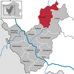
| Location of the community of Schmelz in the Saarlouis district | ||
  |
||

Schmelz is a municipality in the Saarlouis district in the Saarland .
geography

Schmelz is located in the northern Saarland mountain and hill country (200 to 430 m above sea level) on the Prims . It is the most populous municipality in the northern Saarland (16,068 inhabitants, as of December 31, 2018)
Neighboring communities
The following communities border on Schmelz: Beckingen (MZG) , Wadern (MZG) , Nalbach (SLS) , Lebach (SLS) , Tholey (WND) , Losheim am See (MZG) .
The parish name
The community of Schmelz takes its name from Bettinger Schmelz , an earlier iron smelter that was founded in 1686 by the French family de Lenoncourt . Charles Henry Gaspard de Lenoncourt († 1713) received a smelter concession from the French King Louis XIV for his rule in Dillingen, which also included Bettingen. The hut was on the banks of the Prims and at times consisted of two smelting furnaces, a stamping mill and a foundry for take plates and household items. The ore came from the opencast mining in the area around Lebach , Gresaubach and Rümmelbach , the charcoal came from the wooded area, and the water power of the Prims was used to drive the machines. After the switch from charcoal to coke, there were too many disadvantages in terms of location, as the coal had to be brought from the more distant coal regions in the Saarland, so the smelter was closed in 1868.
Community structure
The place is divided into Schmelz (Außen and Bettingen with Goldbach and Schattertriesch), Hüttersdorf (with Buprich), Limbach , Michelbach, Primsweiler and Dorf im Bohnental .
history
The community of Schmelz has only existed since April 1, 1937. On January 1, 1974, the previously independent communities of Dorf, Hüttersdorf, Limbach (Saarlouis district), Michelbach and Primsweiler were added.
politics
Municipal council
The local elections on May 26, 2019 brought the following result. The council is composed as follows:
|
A total of 33 seats
|
mayor
- until 1991: Konrad Steffen, CDU
- 1991 to October 2019: Armin Emanuel, SPD
- October 2019 until today: Wolfram Lang, SPD
Mayor
- Schmelz: Thomas Lamberti (SPD)
- Hüttersdorf: Bernd Valentin (SPD)
- Limbach: Bernard Zimmer (CDU)
- Primsweiler: Hans Siedlaczek (SPD)
- Michelbach: Frank Edlinger (SPD)
- Village in Bohnental: Manfred Buchheit (CDU)
coat of arms
The blazon reads: "In silver a continuous notched red cross, covered with a heart shield, in it in silver on a green base a silver-grooved black furnace with red tapping and a red flame knocked out above."
Partnerships
- Mitry-Mory , France (since 1972)
- Astfeld, Sarntal , South Tyrol (since late 1971)
Economy and Infrastructure
traffic
By the municipality of melting which extends federal highway 268 which, inter alia, the capital of the Saarland ( Saarbrücken ) with the in Rheinland-Pfalz located Trier connects. In addition, extensive work on the road network has been carried out in recent years, which means that Schmelz now has three main traffic circles and a newly designed town center. In addition, the larger community is connected to the local transport network of the Saarlouis roundabout , which means that the local residents have access to all of the larger cities in the area.
Companies
- Meiser (Limbach)
- Spig (Limbach)
Educational institutions
Day care centers
- Day care center "St. Stephan" in Schmelz-Bettingen
- "Tabaluga" daycare center in Hüttersdorf
- Kindergarten "Unterm Regenbogen", in Schmelz-Limbach
- Catholic kindergarten "St. Josef", in Schmelz-Außen
- KiTa "Cross Elevation", in Hüttersdorf
Elementary schools
- Stefanschule Schmelz with its Limbach branch
- Johannesschule Hüttersdorf
Community school
- Kettelerschule Schmelz - community school
Culture and sights
- Attractions

Chapel on Marienfried

Thick oak

Cutting rollers memorial
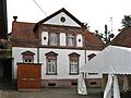
Bettinger Mill

Waterworks with trompe l' oeil photo of the interior


.jpg)
- The Bettinger Mühle cultural monument is a mill ensemble with a mill building, residential building, workshop, bakery and barn, which is being restored as a cultural center by the Association for the Preservation of Bettinger Mühle.
- The Mühlenberg near Bettingen is probably the remainder of a medieval tower hill castle.
- The outer bell tower is a choir tower of an earlier, possibly Romanesque church, from the 12th century. It has been restored and is now used for religious purposes (location: Schmelz, Robert-Koch-Straße).
- The thick oak natural monument is an approx. 380 year old oak in the Great Horst. The tree is a relic of medium-sized forest management , which was operated until around 1850.
- The old church in Limbach consists of four parts that were built at different times. The oldest of these four parts is the late Romanesque tower. Besides a similar tower in the nearby municipality of Siersburg, there is no building of any kind in the entire Saarlouis district that has reached a similar age. In the book Die Kunstdenkmäler des Kreis Saarlouis and Kreis Ottweiler , the 13th century is given as the time of origin. In the 15th century a Gothic window was added to the tower and a Gothic vault was added inside. On the inner wall there are remains of old pictures depicting the martyrdom of St. Represent Sebastian.
Tower and church survived the Thirty Years War . The choir of the old church attached to the tower probably dates from before the Thirty Years War. - The Birg bei Limbach is a Celtic rampart that is located on an elevation of a foothill of the Great Horst.
- The Hüttersdorfer Chapel (Kapellenweg)
- The Church of Our Lady of Sorrows (Michelbach) was built in 1932.
- The chapel on Marienfried (Renges) was built in 1949 and consecrated in 1950. The chapel was built out of gratitude, as there were no injuries in an air raid on a fully occupied passenger train.

- The Heidebad in Schmelz is the largest outdoor pool in the area with 2 swimmer pools, 1 non-swimmer pool, 1 toddler pool, 1 diving pool with 5 diving boards, 1 plunge pool and a 90-meter-long slide.
- Engelgrundweiher in Hüttersdorf.
See also: List of architectural monuments in Schmelz
climate

The annual precipitation is 1048 mm and is thus in the upper third of the values recorded by the measuring points of the German Weather Service . Over 87% indicate lower values. The driest month is April; it rains most in December. In the wettest month there is around 1.6 times more rain than in the driest month. The seasonal fluctuations in precipitation are in the upper third. In 67% of all places, the monthly precipitation fluctuates less.
Personalities
- Karl Baus (1904–1994), Catholic church historian and patrologist
- Wolfgang “Ambrosius” Leidinger (* 1958), Benedictine, head of the Neuburg Abbey near Heidelberg
- Roland Merten (* 1960), educational scientist and State Secretary in the Thuringian Ministry of Education, Science and Culture
- Herman Rarebell (* 1949), former Scorpions drummer , born in Hüttersdorf-Buprich
- Erwin Sinnwell (1929–2014), former Minister for Economic Affairs, Transport and Agriculture of the Saarland in the Röder V cabinet
literature
- Schmelz - past and present. A home book. Self-published in 1973
Web links
- Official website of the community of Schmelz
- Literature on Schmelz (Saar) in the Saarland Bibliography
Individual evidence
- ↑ Saarland.de - Official population figures as of December 31, 2019 (PDF; 20 kB) ( help ).
- ↑ Statistics of the German Reich, Volume 450: Official municipality directory for the German Reich, Part I, Berlin 1939; Page 278
- ^ Federal Statistical Office (ed.): Historical municipality directory for the Federal Republic of Germany. Name, border and key number changes in municipalities, counties and administrative districts from May 27, 1970 to December 31, 1982 . W. Kohlhammer, Stuttgart / Mainz 1983, ISBN 3-17-003263-1 , p. 808 .
- ↑ a b Saarland Statistical Office, The State Returning Officer, municipal council elections, Schmelz . Retrieved July 9, 2019
- ↑ final-results-municipal-election-2019.html
- ^ Saarländischer Rundfunk: Wolfram Lang new mayor in Schmelz. May 27, 2019, accessed May 28, 2019 .
- ^ Saarbrücker Zeitung: Mayor Schmelz. Huberty successor . Retrieved May 23, 2019
- ^ Community of Schmelz: day-care centers: Community of Schmelz. Retrieved June 19, 2018 .
- ↑ a b Community of Schmelz: Schools: Community of Schmelz. Retrieved June 19, 2018 .
- ↑ Picture from the tower of the old church in Limbach
- ↑ Plans and pictures of the Birg near Limbach
- ^ Community of Schmelz: Heidebad Schmelz. Retrieved November 10, 2019 .
- ↑ Heidebad Schmelz. In: Community of Schmelz. Retrieved March 17, 2019 .
Bous | Dillingen / Saar | Ensdorf | Lebach | Nalbach | Rehlingen-Siersburg | Saarlouis | Saarwellingen | Enamel | Schwalbach | Overlord | Wadgassen | Catfish catch