Schloßstraße (Berlin-Charlottenburg)
| Schlossstrasse | |
|---|---|
| Street in Berlin | |
| View from Schloßstraße to Charlottenburg Palace | |
| Basic data | |
| place | Berlin |
| District | Charlottenburg |
| Created | 1697 |
| Hist. Names |
Große Allee, Breite Straße |
| Connecting roads |
Spandauer Damm , Kaiserdamm |
| Cross streets | look here |
| Places | Sophie-Charlotte-Platz |
| Buildings | look here |
| use | |
| User groups | Pedestrian traffic , bicycle traffic , car traffic , public transport |
| Road design | Johann Arnold Nering |
| Technical specifications | |
| Street length | 900 meters |
The Schloßstraße in the Berlin district of Charlottenburg ( Charlottenburg-Wilmersdorf district ) is about 900 meters long and 70 meters wide, a popular tourist avenue in the German capital that connects Sophie-Charlotte-Platz with Charlottenburg Palace .
location
Schloßstraße creates the connection between Spandauer Damm and Sophie-Charlotte-Platz, on which Bismarckstraße , Kaiserdamm and Suarezstraße are located. It is one of the oldest streets in Charlottenburg. From the branching off Zillestrasse and Knobelsdorffstrasse to the castle, it forms a central promenade with two lanes - lined with lime trees. It is around 72 meters wide here. Schloßstraße is part of a visual axis that continues in the castle garden and ends with an obelisk , which is also around 900 meters in the extension of this axis. In the center of this line of sight is the dome of the palace. This form of the baroque complex was already designed as a representative driveway promenade by the palace architect Johann Arnold Nering . It is symmetrically related to the axis that leads from the street Unter den Linden to the west. In 1697 the French gardener Simon Godeau added two more oblique lines of sight to the ensemble, which aimed at Schönhausen Palace and the Spandau Citadel .
To the west of Schloßstraße is the Klausenerplatz-Kiez , to the east the Schustehruspark.
Naming
In 1697 the road was built in connection with the castle. After the castle, initially called Lietzenburg , was completed in 1699 under Martin Grünberg , the street was initially named Große Allee around 1701/1702 and was also called Breite Straße . It has only been called Schloßstraße since the end of the 18th century . The original street name continues to be written with "ß" as a proper name despite the spelling reform .
Road design


In the Baroque era, the buildings reached from the courtyard of Charlottenburg Palace to the south only around 800 meters and initially only led to the height of the confluence of today's Knobelsdorffstrasse. Schloßstraße was originally a purely residential street and ended at the intersecting Schwarzen Graben , a swampy extension of the Lietzensee that ran north-east and which originally extended to the Spree . The watercourse, also known as the Lietzengraben , was widened to a carp pond at the level of Schloßstraße in 1711 and formed the end of Schloßstraße until late in the 19th century. Schustehrusstraße formed a connection to the street leading into the city of Berlin. More important than the land connection between Berlin and Charlottenburg was the more direct route via Berliner Straße (today: Otto-Suhr-Allee ), which overtook Schloßstraße as a tourist destination with numerous rest stops.
Schloßstraße was redesigned for the first time in 1841/1842 by order of Friedrich Wilhelm IV and the characteristic median was added. There were problems in the early days , as the street with the increased volume of traffic and the adverse conditions (high groundwater level and poor sewage system) was the reason for multiple complaints from citizens. In 1885/1886 the Schloßstraße was redesigned once more by the Lenné student Hermann Mächtig (1837–1909) and received its first paving . The section from Knobelsdorffstraße to Sophie-Charlotte-Platz was only paved in 1891. In 1892 the section from Zillestrasse to Sophie-Charlotte-Platz was officially included in Schloßstrasse. In a city map from 1894, today's Suarezstrasse is indicated as "Extended Castle Street". The Kaiserdamm was not completed until 1905, and there was thus a direct connection to the inner city of Berlin.
Around 1900 it became apparent that Schloßstraße had gradually lost its reputation as a "good address" and that better-off citizens were more likely to live in the newly developed Westend . In Schloßstraße itself, a difference in the population structure could be determined between the western side, where the infant mortality rate in the often narrow and damp backyard apartments was among the highest in Charlottenburg, with the red Klausenerplatz-Kiez and the eastern side, on which, for example, the Villa Oppenheim (then with tennis court and spacious garden) is located. In World War II, many buildings were destroyed, especially at the junction with the Zillestraße and near the Sophie-Charlotte Square. Little of the historical structure has been preserved here.
The houses are provided with the horseshoe numbering common in Berlin . It starts at the castle on the west side with the number 1 and runs counterclockwise to end again opposite the castle on the east side.
Buildings
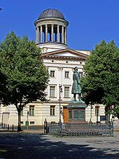
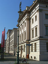
From 1851 to 1859 Friedrich August Stüler built the two officers' barracks of the Gardes du Corps opposite the Charlottenburg Palace at Schloßstraße 1 and Schloßstraße 70 based on designs by King Friedrich Wilhelm IV . The western Stüler building was converted into a police institute in 1929, where training courses for the Prussian police took place. In 1933 the institute became the central training facility for the criminal police, and in 1937 it was renamed the “ Security Police Leadership School ”. After the Second World War, the Labor Office III moved in and when, for the first time after the Wall was built, the border to the east was permeable again in 1964 , there was a temporary passport office here. The Berggruen Collection has been in the building since 1995 (with works by Picasso , Klee , Matisse and others). The Egyptian Museum was housed in the eastern Stüler building from 1967 to 2005 . Since July 2008, after an extensive renovation, works by surrealist artists from the Scharf-Gerstenberg Collection have been shown here. The Prince Albrecht Monument , designed by Eugen Boermel and Conrad Freyberg , has stood between the two Stüler buildings since 1901 .
In 1858 the Charlottenburg gymnastics and sports club was founded. With him, the development of sport in Charlottenburg began. The first sports hall was built in 1860 at Schloßstraße 1a in the courtyard behind today's Bröhan Museum , the museum for Art Nouveau , Art Deco and Functionalism .
After Charlottenburg was granted city rights in 1705, the first town hall to be used was the Palais of the master stable master d'Ausson de Villarnoux in Schloßstraße 2. The building from 1702 designed by Eosander von Göthe was the first in Schloßstraße. The house, with its splendid interior , was demolished in the 1880s after the administration had moved to Otto-Suhr-Allee to the poor house and asylum for the homeless. The 3./4. Community school built, which was destroyed in World War II. Currently (as of 2010) there is a senior citizens' home there.
The house at Schloßstraße 6, also designed by Eosander von Göthe, was the home of the Turkish valet Hassan, who was employed at Sophie Charlotte's court , until it was destroyed in World War II . A plaque commemorates him . The house was used as a summer home by the sculptor Christian Daniel Rauch from 1855 to 1857 . In 1951, the newly built Seventh-day Adventist Church was consecrated at the same location .
A memorial plaque on the house at Schloßstraße 22 commemorates the communist Otto Grüneberg , who was the political victim of an SA storm in 1931 .
Until it was destroyed in World War II, there was a secondary school named after Werner von Siemens at Schloßstraße 27 directly on Sophie-Charlotte-Platz , the iron bars of which have been preserved. Today there is a retirement home on the site.
The Villa Oppenheim (Schloßstraße 55) can be reached via Otto-Grüneberg-Weg, which was rebuilt in 1881/1882 according to plans by the Berlin architect Christian Heidecke and which has housed the Charlottenburg-Wilmersdorf Museum of Local History and History since 2012.
The Oppenheim Oberschule ( Silesia Oberschule until 2003 ) is located in Schloßstraße 55a in a two-winged complex built by Hans Winterstein from 1919 to 1922 . It includes the large gym at Schloßstraße 56, built from 1985 to 1987 according to plans by Inken and Hinrich Baller , which has been called Carl-Schuhmann-Halle since 1998 , named after Carl Schuhmann , one of the most successful and versatile athletes at the first Olympic Games in 1896 .
The oldest rental villa (1873/1874 by Georg Toebelmann ) is at Schloßstraße 67 . The front garden has been reconstructed according to old plans.
In 1987 the home museum Charlottenburg was opened in the house at Schloßstraße 69. At the end of 2011, the now Museum Charlottenburg-Wilmersdorf moved into the Villa Oppenheim. The natural science collection of West Berlin has been located in the neighboring house at Schloßstraße 69a since 1987. It was taken over in 1995 by the Stiftung Stadtmuseum Berlin , which gave up this museum location in 2011.
Transport links
The Sophie-Charlotte-Platz underground station on the U2 line is located at the southern end of Schloßstraße . Bus line 309 runs across the entire Schloßstraße with several stops. The M45 buses stop at Schloßstraße and Spandauer Damm.
Back streets
West direction
- Neufertstrasse
- New Christstrasse
- Seelingstrasse
- Knobelsdorffstrasse
- Horstweg
East direction
- Stallstrasse
- Wulfsheinstrasse
- Schustehrusstrasse
- Otto-Grüneberg-Weg
- Hebbelstrasse
- Zillestrasse
literature
- Henrike Hülsbergen (publisher): Charlottenburg really is a city - from the unpublished chronicles of Johann Christian Gottfried Dressel (1751–1824) , Berlin 1987, ISBN 3-925683-04-6
- Herbert May: Once an ornament of the residence. The Schloßstraße in Charlottenburg . System Druck, Berlin 1992.
- Sonja Miltenberger: Charlottenburg in historical maps and plans , Berlin 1998, ISBN 3-932202-32-5
Web links
- Schlossstrasse. In: Street name lexicon of the Luisenstädtischer Bildungsverein (near Kaupert )
Individual evidence
- ↑ Article (1967) by Margarete Kühn, which brought about the reconstruction of the palace at the Association for the History of Berlin e. V.
- ↑ Destruction of the war in 1945 ( page no longer available , search in web archives ) Info: The link was automatically marked as defective. Please check the link according to the instructions and then remove this notice. at alt-berlin.info
- ↑ Notification from the district office ( Memento of the original from September 29, 2007 in the Internet Archive ) Info: The archive link has been inserted automatically and has not yet been checked. Please check the original and archive link according to the instructions and then remove this notice.
- ↑ Collection Scharf-Gerstenberg at the State Museums
- ^ History of Charlottenburg in the district lexicon at berlin.de
- ↑ Bezirkslexikon at berlin.de
- ↑ A man with a history . In: Der Tagesspiegel , November 24, 2003
- ^ Advent house in the district lexicon of the Luisenstädtischer Bildungsverein
- ^ Carl-Schuhmann-Halle in the district lexicon of the Luisenstädtischer Bildungsverein
- ↑ When the rabbit says good night . In: Der Tagesspiegel , April 20, 2011
Coordinates: 52 ° 30 '48.8 " N , 13 ° 17' 48.8" E


