
Karmøy
| coat of arms | map | ||
|---|---|---|---|

|
|
||
| Basic data | |||
| Commune number : | 1149 | ||
| Province (county) : | Rogaland | ||
| Coordinates : | 59 ° 17 ′ N , 5 ° 18 ′ E | ||
| Height : | 1 moh. | ||
| Surface: | 229.96 km² | ||
| Residents: | 42,186 (Feb 27, 2020) | ||
| Population density : | 183 inhabitants per km² | ||
| Language form : | neutral | ||
| Postal code : | 4250 Kopervik | ||
| Website: | |||
| politics | |||
| Mayor : | Jarle Nilsen ( Ap ) (2015) | ||
| Location in the province of Rogaland | |||

|
|||

Karmøy is a municipality on the island of the same name in Rogaland in Norway . It lies between Stavanger and Haugesund . The administrative administration is located in Kopervik .
geography
The island is connected to the mainland by a bridge over Karmsund . The highest point in the municipality is Søra Sålafjellet ( 132 moh. ) South of Kopervik. Karmøy is located in the countryside Haugaland .
The formerly independent municipalities of Vedavågen , Sandve , Ferkingstad and Visnes were merged in 1965 to form the municipality of Karmøy.
There are three cities in the municipality: Kopervik , Skudeneshavn , Åkrehamn .
history
The Karmøy hoard consists of 25 flint daggers and a number of flint tools and flakes that were imported from Denmark and found at Hauske.
The oldest place on the island is Avaldsnes north on the island at Karmsund.
The place is known for its archaeological finds, including burial mounds from the Bronze Age, the most richly equipped gun grave of the younger Roman period ( Flagghaug ), as well as a Storhaug , typologically and radiologically dated to the 8th century AD, and a ship's grave ( Grønhaug ), which dates from the first half of the 10th century. The dating of the ship's grave at Storhaug , which is the oldest such burial in Scandinavia, gave rise to widespread speculation.
The earliest Norwegian kings of scriptural tradition have come down to us from the western part of the country. Thus, the cradle of Norwegian royalty was probably in the west and not, as the saga writers claim, in the east of the country.
Avaldsnes is one of the traditional royal seats at the end of the Viking Age and was a place with an early Romanesque stone church in the 12th century. Here was the Tingplatz ( fjerdingsting ) for the northern Rogaland.
Since the 1980s, the opinion has spread that Avaldsnes was also an early trading port. This is based u. a. on the name-based indicator ( Lahamaren ). By studying mediaeval sources, it was found that the Hanseatic office known as Nothow / Notau / Note was located near Avaldsnes, where corresponding archaeological finds were made. The recovery of ceramics from the 14th / 15th centuries Century, which comes mainly from Germany and the Netherlands, succeeded in the port. As an extension of this thesis, it can be assumed that, similar to Gudme, there was an Iron Age trading post in Avaldsnes, which, however, was comparatively modest in size.
traffic

Skudeneshavn in the south of the island could be reached by ferry from Stavanger via Mekjarvik in just over an hour. This was discontinued after the opening of the Karmøy tunnel. There are currently no connections in the direction of Stavanger that are open for cyclists, except for very long detours through the interior. The 650 meter long Karmsund Bridge leads from Avaldsnes to Haugesund . There has been a submarine road connection to the E 39 since 2013 through the 8,900 m long Karmøy tunnel .
Karmøy International Airport connects the region with Oslo , Bergen , Sandefjord (Torp) and London (with Ryanair ).
economy
In addition to agriculture, trade, fishing and shipping, aluminum production ( Hydro Aluminum Karmøy ) plays a major role.
Culture and art

Tumulus on Karmøy
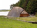
Reconstruction of a Viking house in Avaldsnes

Avaldsnes Church With Mary's Sewing Needle


Avaldsnes was the residence of Harald Fairhair in the 9th century. The 13th century St. Olav's Church with Mary's sewing needle , a stone pillar, is well worth seeing . In spring 2005, an underground museum in the Nordvegen Historical Center was inaugurated. There is a reconstruction of a Viking village nearby. A large grave field from the Bronze and Iron Ages can be visited at the “Deer Hill” (Avaldsnes) . But the oldest finds come from the older Stone Age. There was a flint industry here in the Neolithic Age.
In Skudeneshavn with its late classical old town there is the small museum Maelandgåden with a shop from the 19th century.
In Visnes there is a local museum on the site of a former copper mine. The copper for the Statue of Liberty , which the French donated to the city of New York , probably came from this mine .
The building stones at Ferkingstad are evidence of the Viking Age .
Personalities from the municipality of Karmøy
- Þormóður Torfason , Icelandic-Danish historian.
- Leif Ove Andsnes , classical pianist
- Anne Margrethe Hausken , orienteer
- Svein Munkejord , politician
- Egil Østenstad , football player
- Thorhild Widvey , former Minister for Oil and Energy
literature
- Sveinung Bang-Andersen: Key words Flaghaug, Grønhaug, Storhaug. In: Einar Østmo, Lotte Hedeager (ed.): Norsk arkeologisk leksikon . Oslo 2005.
Web links
Individual evidence
- ↑ Statistisk sentralbyrå - Befolkning
- ↑ Bang-Andersen pp. 111, 143, 363.