
Richard the Lionheart tourist route
The 200 kilometer long French Richard Löwenherz tourist route ( French Route Richard-Cœur-de-Lion ) runs through the Charente , Corrèze , Dordogne and Haute-Vienne departments . On its course it touches a Roman city as well as numerous medieval sights , including castles, churches and palaces.
description

The Richard the Lionheart tourist route runs through the border area between Périgord and Limousin . It consists of three branches. The first branch starts from Rochebrune Castle (near Étagnac ) in the Charente department, the second from Arnac-Pompadour in the Corrèze department and the third from Limoges in the Haute-Vienne department. The three branches meet in Nexon in Haute-Vienne. There are 23 sites and monuments historiques along the road . Remarkable landscapes with their numerous riches are crossed. The street is named after the English King Richard the Lionheart , who died in Châlus in 1199 during a siege of Châlus-Chabrol Castle .
Route

First branch
- Charente department:
- Étagnac with Rochebrune Castle, founded in the 11th century
- Chassenon with the Roman settlement Cassinomagus - 1st to 4th century
- Haute-Vienne department:
- Rochechouart with Rochechouart Castle - 12th century
- Les Salles-Lavauguyon with Saint-Eutrope church - 12th century
- Saint-Mathieu with the church of the same name - 12th century
- Cussac with the sacred spring of La Mazaurie
- Champagnac-la-Rivière with Brie Castle - 15th century
- Dournazac with Montbrun Castle - 12th century
- Châlus with Châlus-Chabrol Castle and Châlus-Maulmont Castle - 11th and 13th centuries
- Les Cars with Bur Les Cars - 16th century
- Rilhac-Lastours with Lastours Castle - 10th century
- Nexon with Nexon Castle - 17th century
Photo gallery
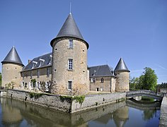
Rochebrune Castle
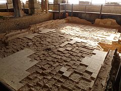
East Cassinomagus warm water basin
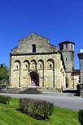
The Saint-Eutrope church in Les Salles

Sacred spring of La Mazaurie near Cussac

Lastours castle ruins
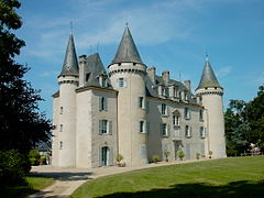
Nexon Castle


Second branch

- Corrèze department:
- Arnac-Pompadour with Pompadour Castle - 11th century
- Lubersac with Saint-Étienne de Lubersac church - 10th and 13th centuries
- Ségur-le-Château with the Ségur castle ruins - 14th and 15th centuries
- Haute-Vienne department:
- Coussac-Bonneval with Bonneval Castle - 13th to 17th centuries
- Saint-Yrieix-la-Perche with the Saint-Yrieix collegiate monastery from the 11th century
- Dordogne department
- Jumilhac-le-Grand with Jumilhac Castle - 13th and 17th centuries
- Haute-Vienne department:
- Le Chalard with Notre-Dame du Chalard priory - 11th and 12th centuries
- Saint-Hilaire-les-Places with Saint-Hilaire church - 12th century
- Nexon
Third branch
- Haute-Vienne department:
- Limoges with the Saint-Etienne cathedral - 13th century
- Solignac with St-Pierre-St-Paul Abbey Church - 12th century
- Saint-Jean-Ligoure with Château de Chalucet - 12th century
- Nexon
geography

In terms of landscape, the first branch of the tourist route begins in the Haute-Charente . After crossing the Vienne near Chassenon , the route changes to the Rochechouart plateau, which is part of the Limousin plateau . The Tardoire is then crossed south of Lavauguyon. The ridge of the Monts de Châlus begins at Saint-Mathieu , which the first branch follows in an easterly direction to its end in Nexon. The distance covered is approximately 81 kilometers. The lowest point of the route is at 160 meters on the Vienne, the highest at 546 meters in the Forêt de Lastours .
The second branch, coming from the south, initially runs through the southern Plateau du Limousin, which is drained by the Auvézère , Loue and Isle , which flow to the southwest . The Monts de Châlus are reached north of Le Chalard and crossed in a northerly direction to the end point Nexon. The total route length is 83.5 kilometers. The lowest point along this section is at 271 meters at the Auvézère near Ségur-le-Château, the highest point is at 439 meters southwest of Saint-Hilaire-les-Places in the Monts de Châlus.
The third branch begins on the Vienne in Limoges and then enters the northern plateau du Limousin, which is drained here to the northwest by the Briance , a left tributary of the Vienne. At the end point at Nexon, the Monts de Châlus are finally reached. The total length of the route is only 37.5 kilometers. The deepest point is at 223 meters on the Vienne in Limoges, the highest point at 416 meters is at La Plaine (municipality of Saint-Maurice-les-Brousses ) just before Nexon.
geology
The Richard Löwenherz tourist route moves entirely in the crystalline basement of the northwestern Massif Central . All three large tectonic units of the Variscikum in the Limousin are crossed: the parautochthonous Saint-Mathieu-Dom , the lower and the upper gneiss cover . A special feature is the Rochechouart-Chassenon crater , which was formed around 200 million years ago when a meteorite struck the basement. In addition to highly metamorphic gneisses and mica schist , a large number of igneous rocks are found, such as granites , leuco granites and quartz diorites . But also smaller remnants of oceanic crustal rocks, which are now available as serpentinites and amphibolites , have been preserved.
The starting point of the first branch is on the Chirac-Étagnac granite , which is intruded into the gneiss of the lower and upper gneiss cover that meets here. South of the Vienne then appear flat ejecta breccia of the meteorite crater. In several facies they continue to cover paragneiss of the lower gneiss blanket, but also granitoids such as the Saint-Gervais granite . To the south of Saint-Gervais , the leuco granites of the Chéronnac leukogranite and the Saint-Mathieu leukogranite are then touched. The latter is then run over on its eastern edge at La Forge (Saint-Mathieu) by the West-Vergenten lower gneiss cover. The lower gneiss cover begins with mica slates of the parautochthonous mica slate unit . They are followed by Augengneise , Leptynite and Paragneiss, which are also strongly interwoven with West-Vergent. Oceanic rocks, such as z. B. Amphibolites and serpentinites between Cussac and Châlus. Shortly before Les Cars on the eastern slope of the Tuquet de la Garde, the upper crosses the lower gneiss cover. The bottom of the gneiss cover consists of paragneiss and amphibolitical scales. Its main mass, however, is made up of the fine-grained, Monzonite Les Cars granite , which is up to Nexon.
The second branch begins in paragneiss of the upper gneiss cover, which are folded in here to form the spacious Uzerche synclinorium, which strikes in an easterly direction . The upper gneiss cover was pushed back in a northerly direction onto a saddle structure of the lower gneiss cover ( Meuzac anticlinory ). The Lubersac quartz diorite belonging to the Limousin tonalite line is found between Lubersac and Ségur-le-Château . Not far south of Coussac-Bonneval, the change to the lower gneiss cover takes place, which is only left north of Ladignac-le-Long . The upper gneiss cover now appears again, which was pushed to the south with paragneiss and ophiolite residues from the former Limousin Ocean. Finally, the Les Cars granite is crossed from Saint-Hilaire-les-Places to Nexon.
The third branch begins in the flat anatectic gneisses of the Limoges migmatite complex , which belong to the lower gneiss cover. After traversing the Aureil granite with its extraordinary gang-troops sent to the northeast, the paragneiss (with activated amphibolite bands ) and leptynite of the upper gneiss cover are found in front of Solignac. After briefly touching the Saint-Jean-de-Ligoure diorite , the journey ends again in Les Cars granite with the Aixette Nexon quartz diorite adhering to the north near Nexon.