Trattenbachtal (Oberpinzgau)
| Trattenbach | ||
|
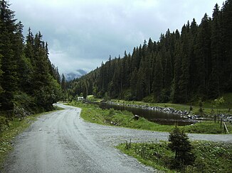
Reservoir for generating electricity in the central Trattenbachtal, with construction for a small power station |
||
| Data | ||
| location | Kitzbühel Alps ; Zell am See district , State of Salzburg | |
| River system | Salzach | |
| Drain over | Salzach → Inn → Danube → Black Sea | |
| River basin district | Danube above Jochenstein | |
| source | on the Kröndlhorn at the Trattenbach-Hochalm 47 ° 17 '36 " N , 12 ° 10' 14" E |
|
| Source height | approx. 2160 m above sea level A. | |
| muzzle | in large pastures (Wald), forest in Pinzgau (Flusskm. 207.34) 47 ° 14 '36.6 " N , 12 ° 13' 51.64" O |
|
| Mouth height | 862 m above sea level A. | |
| Height difference | approx. 1298 m | |
| Bottom slope | approx. 13% | |
| length | 10.1 km | |
| Left tributaries | Filzbach | |
| Right tributaries | Tortalbach, Happingbach | |
| Communities | Wald im Pinzgau , Neukirchen am Großvenediger | |
| Small power plant Trattenbach | ||
The Trattenbachtal , the valley of the Trattenbach , is a small side valley of the Oberpinzgau (uppermost Salzach valley ) in the Kitzbühel Alps , in the municipality of Neukirchen am Großvenediger and Wald im Pinzgau .
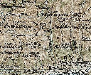
Location and landscape
The valley begins directly above the village of Wald, which is located on the Schuttriedel of the Trattenbach. In the slope terraces of the Salzach, between Baxrain ( left , Neukirchen municipality) and Vorderwaldberg (right, forest), the brook has left a deep cut that is largely wooded and impassable.
The middle reaches gently between Trattenbacheck ( 2063 m above sea level , left) and Laubkogel ( 2317 m above sea level , right) northwards. It has a partly free valley floor and is otherwise also densely forested.
In the area of the basin below the Sonntagsalm on the Steinkogel ( 2299 m above sea level ), the valley turns to the west, takes a slope shoulder and leads as a wide high valley, the Trattenbachalm , with Freimöserkopf ( 2005 m above sea level ) and Mitterkopf ( 2306 m above sea level ) in the north, to the headwaters on the Kröndlhorn ( 2444 m above sea level ). A ziehweg / forest path ( ⊙ ) leads through the valley from Neukirchen-Roßberg.
Course of the Trattenbach
The stream itself rises in the area of the Trattenbach-Hochalm, at altitudes above 2100 m, from numerous small spring channels. At the Talknick it takes the Filzbach from the Filzscharte ( 1686 m above sea level , into the Tyrolean Windau Achental ) from the north . From the Laubkogel there are two larger tributaries: Tortalbach (Tortal after the Toreck, 2160 m above sea level , secondary summit of the Laubkogel) and Happingbach (from the Happingalm). At Wald the brook enters the Salzach Valley and flows 400 m south of the village from the left into the Salzach .
geology

The Trattenbachtal not belong more to Grauwackenzone that builds the Kitzbühel Alps good part, but already for - starting at Mittersill - Innsbruck Quarzphyllitkomplex that are phyllites and quartz Phylite (clay mica schist ), including - geological - not to the Northern Limestone Alps , but the Koralpe – Wölz ceiling system of the Central Alps . The rocks are old Paleozoic (unspecifically older than about 250 million years), so they are among the oldest formations in the Alps. The eastern mountains form a geological peculiarity, the Steinkogel slate complex , a cover layer of partly garnet-bearing slate with quartzites , gneiss and amphibolites . To the west, on the Laubkogel, there are clods of paleozoic limestone, marble and dolomite . The different rocks also form the asymmetrical cross-section of the valley, the harder Steinkogel schists form a valley flank of 35 °, the softer phyllites of 20 °. On both sides of the Middle Valley, but especially in the Phyllite, there are mighty, extensive subsections , rock masses moving in association, a probably unique, late or post-glacial event. The Hintertal is geologically stable, with glacier rubble ( moraine remnants on both sides of the valley).
Torrent protection and water use (Trattenbach power plant)
The valley is repeatedly hit by severe storms. About 1800 meters after the start of the draw travel is on the left side of a retention basin with dam debris ⊙ . In 2006 and 2011, for example, it became necessary to restore the forest road in pieces because debris flows had torn it away. In 2011, the cattle had to be temporarily driven from the alpine pasture because the milk could not be exported.
At the confluence in Wald there is a small hydropower plant for generating electricity (Trattenbach power plant) , with the discharge (Trattenbach storage basin ) 700 m above the retention basin (river km 5 ,, ), with the power house directly on the Salzach ( ⊙ ). A second small plant can be found on the upper reaches, the Niederkaser power plant (Kröll, ⊙ ).
Paths and tours

The valley can be reached from the south via hiking trails from Vorderkrimml and Wald via Vorderwaldberg and from Rosental (Neukirchen community), Vendigersiedung and Neukirchen via the Roßberg supply route (Neukirchen community).
The road into the valley is also through the Goethe path with stations of Goethe's color theory equipped for children, a project of the Department of Conservation of Salzburg, in the context of the High Tauern National Park .
Through this valley you can to Steinkogel / Speikkogel (Kitzbühel Alps) (2299/ 2232 m ), Kröndlhorn ( 2444 m ), Wildkogel ( 2,224 m ), Gamskogel (Kitzbühel Alps) ( 2206 m ) and Great Rettenstein ( 2366 m rise). The valley can also be used for tours in neighboring Tyrol. Migrates to the Filzbachtal on, you can exceed the Kitzbühel main ridge and passes through the Windauer Achental to Westendorf . The Arnoweg (AW), the Salzburg- wide long-distance hiking trail, crosses the valley (stage 18 Steineralm (Pinzgau) - Krimml , continuation of the Pinzgauer walk from Zell am See to the west).
The Talung is also a popular mountain bike area .
The Sonntagalm and Trattenbachalm (both private) are managed in summer .
In winter the valley is a good, quite safe touring area , the (old) Sonntagalm is available as a self-catering hut.
Web links
- Goethe in the Trattenbachtal! , State of Salzburg, Department 13 - Nature Conservation, www.goetheweg.at
Individual evidence
- ↑ a b c d Information on hydrography according to SAGIS, Land Salzburg GISonline → Layer waters
- ↑ in contrast to the second Trattenbach to the Salzach, near Taxenbach from the Dientner mountains, also listed as Trattenbach forest in the water information system
- ↑ The rock change that takes place here is the reason for the dispute, which continues to this day in alpinism, about the classification of the slate Alps as central or northern Alps: the geological boundaries run diagonally through the middle.
-
↑ Information based on the Austrian Geological Map (GK200 sheet Salzburg );
Geodynamics discussed in detail in Sven Jacobs: Applied Geognosy using three examples. 3. Project appraisal of KW Wald-Trattenbach-Mühlbach (S) . In: B. Schwaighofer, HW Müller (ed.): Building geological seminar , lectures 1991/1992 (= communications from the Institute for Soil Research and Building Geology Department Building Geology, University of Natural Resources and Life Sciences, Vienna , Series: Applied Geosciences , Volume 3), Vienna, March 1993, P. 111 ff. (Article p. 85–126; pdf , baunat.boku.ac.at). - ↑ Trattenbach river power station . In: Salzburger Nachrichten : Salzburgwiki .
-
↑ www.goetheweg.at ;
Tour description from Thomas Man, Bernhard Kern: Trattenbachalm, 1732 m . In: Alpine pasture and hut hikes in the Salzburg region . Pinzgau, Pongau, Dachstein-Tauern. Bergverlag Rother, 2010, ISBN 978-3-7633-3055-3 , p. 39–41 ( limited preview in Google Book Search [accessed December 18, 2012]). - ↑ Section 2 - Pinzgauer Grasberge , arnoweg.com
- ↑ Sonntagalm (1610 m) , stadler-markus.de → Ski touring base in the Eastern Alps / Kitzbühel Alps


