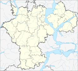
Cherdakly
| Urban-type settlement
Cherdakly
ердаклы
|
||||||||||||||||||||||||||||||
|
||||||||||||||||||||||||||||||
|
||||||||||||||||||||||||||||||
| List of large settlements in Russia | ||||||||||||||||||||||||||||||
Cherdakly ( Russian Чердаклы ) is an urban-type settlement in the Ulyanovsk Oblast ( Russia ) with 11,440 inhabitants (as of October 14, 2010).
geography
The settlement is located 30 km as the crow flies east of the Ulyanovsk Oblast Administrative Center on the left of the Volga , about 13 km from the bank of the 20 km wide river that is dammed up there to form the Kuibyshev reservoir .
Tscherdakly is the administrative center of the Tscherdakly Rajon of the same name .
history
Tscherdakly was built in 1688 as a fortified settlement along the Kama - Verhaulinie (Sakamskaja sassetschnaja cherta) along the then southeast border of Tsarist Russia . First residents were from the region of Penza originating when Cossacks standing in the Russian service Tatars under Suleiman Jangapow and Mordvins . With the relocation of the border to the east in the 18th century, its military importance ceased and Cherdakly became an ordinary village. Tartars in particular, but also Chuvashes , still represent significant minorities in the settlement and Rajon.
At the beginning of the 20th century, the private Volga-Bugulma railway ran through the town and opened on this section in 1914. In the 1920s, Tscherdakly became the administrative center of a Rajon, and in 1957 it was given the status of an urban-type settlement.
Population development
| year | Residents |
|---|---|
| 1939 | 5,643 |
| 1959 | 6,935 |
| 1970 | 8,207 |
| 1979 | 10,449 |
| 1989 | 11.091 |
| 2002 | 12,045 |
| 2010 | 11,440 |
Note: census data
Economy and Infrastructure
The settlement is the center of an agricultural area.
Tscherdakly lies on the railway line Insa - Ulyanovsk - Tschischmy (- Ufa ; route km 927 from Moscow ). The regional road R 178, which comes from Saransk in Ulyanovsk, crosses the Volga and then runs to the left of the river via Dimitrovgrad in the direction of Samara, runs through the village .
Individual evidence
- ↑ a b Itogi Vserossijskoj perepisi naselenija 2010 goda. Tom 1. Čislennostʹ i razmeščenie naselenija (Results of the All-Russian Census 2010. Volume 1. Number and distribution of the population). Tables 5 , pp. 12-209; 11 , pp. 312–979 (download from the website of the Federal Service for State Statistics of the Russian Federation)
- ↑ a b Tscherdakly on the website of the Geographical Institute of the RAN (Russian)
Web links
- Rajon Administration website (Russian)

