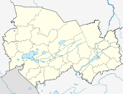
Cherepanovo
| city
Cherepanovo
Черепаново
|
||||||||||||||||||||||||||||||||||||
|
||||||||||||||||||||||||||||||||||||
|
||||||||||||||||||||||||||||||||||||
| List of cities in Russia | ||||||||||||||||||||||||||||||||||||
Tscherepanowo ( Russian Черепаново ) is a city in the Novosibirsk Oblast ( Russia ) with 19,803 inhabitants (as of October 14, 2010).
geography
The city is located in the southeastern part of the West Siberian lowlands , about 110 km south of the Oblast capital Novosibirsk on the M52 trunk road (section Novosibirsk - Biysk ). The climate is continental.
The city of Cherepanowo is the administrative center of the raion of the same name .
history
Cherepanowo was established as a settlement Svobodny ( Свободный ) in 1912 in connection with the construction of the Novosibirsk - Barnaul - Semipalatinsk railway (opened in 1915) in place of a wintering place for resettlers, received its current name in 1921 and town charter in 1925.
Population development
| year | Residents |
|---|---|
| 1939 | 17.122 |
| 1959 | 21,225 |
| 1970 | 21,067 |
| 1979 | 20,974 |
| 1989 | 22,116 |
| 2002 | 20,496 |
| 2010 | 19,803 |
Note: census data
Individual evidence
- ↑ a b Itogi Vserossijskoj perepisi naselenija 2010 goda. Tom 1. Čislennostʹ i razmeščenie naselenija (Results of the All-Russian Census 2010. Volume 1. Number and distribution of the population). Tables 5 , pp. 12-209; 11 , pp. 312–979 (download from the website of the Federal Service for State Statistics of the Russian Federation)
Web links
- Cherepanovo on mojgorod.ru (Russian)


