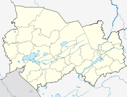
Kochki (Novosibirsk)
| Village
Kotschki
Кочки
|
||||||||||||||||||||||||||||||||||
|
||||||||||||||||||||||||||||||||||
|
||||||||||||||||||||||||||||||||||
Kotschki ( Russian Ко́чки ) is a village (selo) in the Novosibirsk Oblast in Russia with 4055 inhabitants (as of October 14, 2010).
geography
The place is about 175 km as the crow flies west-southwest of the Novosibirsk Oblast Administrative Center in the Barabasteppe . It is located on the right bank of the upper reaches of the Karassuk , opposite the village of Krasnaya Sibir .
Kotschki is the administrative center of the Rajons Kotschkowski and seat and only town in the rural community selsowet (selskoje posselenije) Kotschkowski.
history
The village arose in the second half of the 18th century on the trade route from Karassuk, founded in 1750, to Kolywan . Kotschki (also known as Kotschkowskoje ) remained insignificant for about 100 years , until its population multiplied in the second half of the 19th century due to resettlers from the European part of Russia and the village became the administrative seat of a Volost . Since September 12, 1924 with an interruption between 1963 and 1965, Kotschki has been the administrative seat of a Rajon named after him.
Population development
| year | Residents |
|---|---|
| 1782 | 107 |
| 1857 | 174 |
| 1897 | 2820 |
| 1939 | 3333 |
| 1959 | 2996 |
| 1970 | 3007 |
| 1979 | 3649 |
| 1989 | 4363 |
| 2002 | 4154 |
| 2010 | 4055 |
Note: from 1897 census data
traffic
Kotschki is located on the regional road 50K-17 (formerly R382), which comes from Novosibirsk via Ordynskoje and continues down the Karassuk from Kotschki via the neighboring district center of Krasnosjorskoye to the city of Karassuk and the state border with Kazakhstan (from there further as A17 initially in the direction of Pavlodar ). In Kotschki the 50K-09 branches off to the north, which leads to the city of Kargat, about 100 km away on the federal highway R254 Irtysh Chelyabinsk - Omsk - Novosibirsk. There is also the closest train station on the Trans-Siberian Railway (the "Central Siberian Magistrale" Omsk - Karassuk - Srednesibirskaja near Barnaul is only about 60 km to the south ; however, Kotschki has not yet had a direct road connection to this route).
Web links
Individual evidence
- ↑ a b Itogi Vserossijskoj perepisi naselenija 2010 goda. Tom 1. Čislennostʹ i razmeščenie naselenija (Results of the All-Russian Census 2010. Volume 1. Number and distribution of the population). Tables 5 , pp. 12-209; 11 , pp. 312–979 (download from the website of the Federal Service for State Statistics of the Russian Federation)


