Ordynskoje
| Urban-type settlement
Ordynskoje
Ордынское
|
||||||||||||||||||||||||||||||||||
|
||||||||||||||||||||||||||||||||||
|
||||||||||||||||||||||||||||||||||
| List of large settlements in Russia | ||||||||||||||||||||||||||||||||||
Ordynskoje ( Russian Орды́нское ) is an urban-type settlement in Novosibirsk Oblast ( Russia ) with 10,256 inhabitants (as of October 14, 2010).
geography
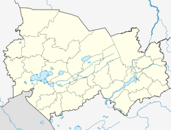
The settlement is located on the left bank of the Ob , which is dammed here to form the Novosibirsk reservoir , about 100 km as the crow flies southwest of the Oblast capital Novosibirsk . At the settlement, the eponymous Orda river flows into the approximately 3.5 km wide reservoir.
Ordynskoje is the administrative center of the Ordynskoje Rajons of the same name . Colloquially, the place is also called Ordynsk or Ordynka .
history
In 1598, about 40 km northeast of today's settlement, on the territory of today's Rajon at the confluence of the Irmen river in the Ob, the decisive victory of the Russian Cossacks against troops of the Siberian Khanate under Kütschüm began, which finally began the Russian colonization of Siberia.
A village at the mouth of the Orda in the Ob was founded by settlers from central Russia at the beginning of the 18th century; It was first mentioned in 1721. By the beginning of the 20th century, it developed into one of the richest villages in what was then Tomsk Governorate .
As part of an administrative reform, Ordynskoje became the administrative center of a Rajons on May 25, 1925. In 1962 the place received the status of an urban-type settlement.
Population development
| year | Residents |
|---|---|
| 1939 | 4,428 |
| 1959 | 5,557 |
| 1970 | 7,677 |
| 1979 | 8,986 |
| 1989 | 9,505 |
| 2002 | 10,448 |
| 2010 | 10,256 |
Note: census data
Culture and sights
Since 1985 there has been a Rajon local museum in Ordynskoje.
In the Rajon there are various archaeological sites, such as the settlement site (" Gorodishche ") Abraschino from the 8th to 7th centuries BC. And a Kurgan from the 5th to 4th century BC. Chr.
Economy and Infrastructure
Ordynskoje's main industries are agriculture and forestry, as well as the food, fish (from the reservoir) and wood processing industries. In the 1990s a significant deposit of titanium (20.9 million tons) and zirconium (5.3 million tons) was discovered in the Rajon , but it has not yet been mined.
The regional road R 380 runs through the village from Novosibirsk via Kamen am Ob to Barnaul . 14 km southwest of the R 382 branches off , which leads via Krasnosjorskoye and Karassuk to the border to Kazakhstan and on towards Pavlodar .
Web links
- Ordynskoye Raion website (Russian)
- Ordynskoye District on the Oblast Administration website (Russian)
Individual evidence
- ↑ a b Itogi Vserossijskoj perepisi naselenija 2010 goda. Tom 1. Čislennostʹ i razmeščenie naselenija (Results of the All-Russian Census 2010. Volume 1. Number and distribution of the population). Tables 5 , pp. 12-209; 11 , pp. 312–979 (download from the website of the Federal Service for State Statistics of the Russian Federation)
- ↑ a b c Ordynskoje on the website of the Geographical Institute of the RAN (Russian)
- ↑ Information about the museum at museum.ru (Russian)


