Masljanino
| Urban-type settlement
Masljanino
Маслянино
|
||||||||||||||||||||||||||||||
|
||||||||||||||||||||||||||||||
|
||||||||||||||||||||||||||||||
| List of large settlements in Russia | ||||||||||||||||||||||||||||||
Masljanino ( Russian Масля́нино ) is an urban-type settlement in the Novosibirsk Oblast ( Russia ) with 13,102 inhabitants (as of October 14, 2010).
geography
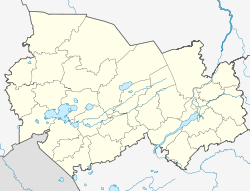
The settlement is located on the western flank of the Salair ridge , a good 110 kilometers as the crow flies southeast of the Oblast capital Novosibirsk , mainly on the left bank of the Ob tributary, Berd .
Masljanino is the administrative center of the Masljanino Rajon of the same name .
history
The place was founded in 1644 by settlers from the European part of Russia. The name is derived from the Russian word maslo for oil and refers to the linseed oil that the settlers extracted from the flax that they cultivated in the fields reclaimed from the taiga .
From the end of the 18th century the village belonged to the Ujesd Barnaul of the Tomsk governorate . Twice, at the beginning and at the end of the 19th century, almost the entire village burned down.
In 1925 Masljanino became the center of a Rajon as part of an administrative reform. In 1944 urban-type settlement was granted.
Population development:
| year | Residents |
|---|---|
| 1939 | 5,431 |
| 1959 | 9,781 |
| 1970 | 10,578 |
| 1979 | 11,883 |
| 1989 | 12,656 |
| 2002 | 13,565 |
| 2010 | 13,102 |
Note: census data
Culture and sights
Various residential buildings from the 19th century and the Nikolai Church from 1896 have been preserved in Masljanino . Since 1978 the place has had a Rajon local museum .
Economy and Infrastructure
In Masljanino as the center of an agricultural area (grain, flax; cattle, pigs) there are companies for the processing of agricultural products as well as forestry and building materials management.
12 km above Masljanino, a small hydroelectric power plant with an output of 600 kilowatts was built on the Berd near the village of Perebor between 1947 and 1951 . Until it was connected to the nationwide power grid, the system served to supply the Rajons with electricity, after which it was dismantled. However, the dam has been preserved ( location ).
The nearest train station is in Cherepanowo on the Novosibirsk – Barnaul railway line . There is a connection to Cherepanowo via a 60 km long regional road, which also has a connection to the M52 trunk road .
References
Individual evidence
- ↑ a b Itogi Vserossijskoj perepisi naselenija 2010 goda. Tom 1. Čislennostʹ i razmeščenie naselenija (Results of the All-Russian Census 2010. Volume 1. Number and distribution of the population). Tables 5 , pp. 12-209; 11 , pp. 312–979 (download from the website of the Federal Service for State Statistics of the Russian Federation)
- ↑ a b Masljanino on the website of the Geographical Institute of the RAN (Russian)
- ↑ Church ( Memento of the original from July 12, 2008 in the Internet Archive ) Info: The archive link was inserted automatically and has not yet been checked. Please check the original and archive link according to the instructions and then remove this notice. on the website of the Novosibirsk Eparchy of the Russian Orthodox Church (Russian)
- ↑ Information about the museum at museum.ru (Russian)
literature
- Vladimir Petrov, Aleksandr Judin: Novosibirsk Oblast . In: Le Petit Futé . 2nd Edition. Avangard, Moscow 2006, ISBN 978-5-86394-104-2 (Russian: Novosibirskaja oblast ʹ . Travel guide series, Russian).

