Cheryomushki (Khakassia)
| Urban-type settlement
Tscherjomuschki
Черёмушки
|
||||||||||||||||||||||||||||
|
||||||||||||||||||||||||||||
|
||||||||||||||||||||||||||||
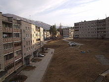
Cheryomushki ( Russian Черёмушки ) is an urban-type settlement in the Republic of Khakassia ( Russia ) with 8373 inhabitants (as of October 14, 2010).
geography
The settlement is located in the valley of the Yenisei through the Western Sayan , about 100 kilometers (as the crow flies) south of the republic capital Abakan on the left bank of the river, which here forms the border to the Krasnoyarsk region. The Yenisei is dammed in this section to the small Maina reservoir ; A few kilometers upriver is the dam of the Sajano-Schuschensk reservoir . To the southeast of the village, the mountains in the Borus ridge with Mount Poilowa rise to an altitude of 2318 m .
Tscherjomuschki belongs to the urban district of some 30 kilometers downstream, at the opening of the narrow valley to the far minusinsk hollow , located Sajanogorsk .
history
The place arose from the mid-1960s in connection with the construction of the Sajano-Schuschensk hydropower plant and initially belonged to the Maina settlement 20 kilometers downstream .
In 1974 Cheryomushki was also granted urban-type settlement status. The name is derived from the Russian word Cheryomucha for bird cherry . After the founding of the subsequently much larger city Sajanogorsk in 1975, both Cheryomushki and Maina were subordinated to this administratively.
The hydropower plant gradually started operating between 1978 and 1985.
Population development
| year | Residents |
|---|---|
| 1979 | 10,415 |
| 1989 | 11,854 |
| 2002 | 9,067 |
| 2010 | 8,373 |
Note: census data

Culture and sights
The main attractions are the 242 meter high and more than one kilometer long dam of the Sajano-Schuschensker reservoir and the nature of the surrounding Sajan Mountains. The area east of the Yenisei is part of the Shushensky Bor National Park .
Due to its location in the high mountains , Cheryomushki is a regional sports center, especially for winter sports .
Economy and Infrastructure
The building company is the hydropower plant operated by RusHydro today , which with 6400 megawatts is the most powerful in Russia. When it went into operation in mid-1985, it was the most powerful hydroelectric power plant in the world alongside the (expanded) Grand Coulee Dam in the United States and is still one of the top ten today.
Cheryomushki is the end point of the regional road R411 , which, starting from Abakan, follows the Yenisei via Sayanogorsk on the M54 Krasnoyarsk - Kyzyl - Mongolian border . The road crosses the Yenisei on a bridge at Cheryomushki in order to connect the right bank of the river and the eastern end of the dam to the transport network.
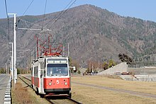
A nearly 100-kilometer-long railway line leading to Tscherjomuschki and the dam , which branches off from the Kamyschta station of the South Siberian Railway Novokuznetsk- Abakan- Taishet and was built in connection with the construction of the dam, is now only in operation as far as Sayanogorsk with its aluminum works. The section within Cheryomushki was partially used for the establishment of a tram route. The single-track route, about 5.5 kilometers long, opened on February 25 or May 18, 1991 and is free of charge .
Individual evidence
- ↑ a b Itogi Vserossijskoj perepisi naselenija 2010 goda. Tom 1. Čislennostʹ i razmeščenie naselenija (Results of the All-Russian Census 2010. Volume 1. Number and distribution of the population). Tables 5 , pp. 12-209; 11 , pp. 312–979 (download from the website of the Federal Service for State Statistics of the Russian Federation)
- ↑ History of the hydropower plant (and the associated settlements) on the website of the current operator RusHydro (Russian)
- ↑ Mikhail Denschik: Атлас городского электротранспорта Российской федерации - Atlas of urban electric transport in the Russian Federation . Издательство "Традиция" ( Isdatel'stvo "Traditsija" ), Krasnodar 2016, ISBN 978-5-91883-245-5 , p. 333 (Russian, English).


