Tuhaň
| Tuhaň | ||||
|---|---|---|---|---|
|
||||
| Basic data | ||||
| State : |
|
|||
| Region : | Středočeský kraj | |||
| District : | Mělník | |||
| Area : | 461 ha | |||
| Geographic location : | 50 ° 18 ' N , 14 ° 32' E | |||
| Height: | 159 m nm | |||
| Residents : | 760 (Jan. 1, 2019) | |||
| Postal code : | 277 41 | |||
| traffic | ||||
| Street: | Mělník - Stará Boleslav | |||
| structure | ||||
| Status: | local community | |||
| Districts: | 1 | |||
| administration | ||||
| Mayor : | Marcela Čechová (as of 2008) | |||
| Address: | Tuhaň 91 277 41 Tuhaň |
|||
| Municipality number: | 531561 | |||
| Website : | www.tuhan.cz | |||
Tuhaň (German Tuhan ) is a municipality in the Czech Republic . It is located seven kilometers southeast of Mělník and belongs to the Okres Mělník .
geography
Tuhaň is located in the Elbe lowlands on the right side of the Elbe on the Tuhaňská strouha canal, an old Elbarm. In the east rises the Záboří hill ( Zaborz , 228 m). To the south, on the other side of the Elbe, is the Spolana factory premises .
Neighboring towns are Kelské Větrušice, Tuhaňské Větrušice and Záboří in the north, Červená Píska in the east, Tišice in the southeast, Neratovice and Libiš in the south and Obříství in the west.
history
Numerous archaeological finds, which can be assigned to the Hallstatt culture of Bylany and the Slavic culture, prove an early settlement in the area of the municipality.
Tuhaň was the property of the monastery of St. Jerome of the Slavs in the New Town and was first documented in 1400, when the monastery the place in the course of an exchange against the Vorwerkshof gave Čakovice to the citizens of Prague in January Seidl. Subsequently, the village belonged to various landlords until it acquired the town of Mělník from the brothers Jiřík Šťastný and Jan Jindřich Vančura von Řehnice in 1604 and connected it to the municipal estate Dolní Přívory. In 1620 the goods of the town of Mělník were confiscated for participating in the class uprising . In 1628 the town got its possessions, including Tuhaň, back after it was pardoned. Tuhaň remained the town's property until the abolition of patrimonial rule in 1850. The inhabitants lived from agriculture, in which the cultivation of cucumbers and some viticulture dominated.
In 1850 Tuhaň became an independent municipality in the Mělník district. Tuhaň was right on the right bank of the Elbe until the river was regulated in 1865 and was affected by every flood of the Elbe. The place was devastated in the great flood of 1890. During the spring flood on March 9, 1891, the village was badly affected by the break in the dykes.
Between 1980 and 1990 the village was incorporated into Kly . When the Elbe floods in 2002 , Tuhaň again suffered severe damage.
Community structure
No districts are shown for the Tuhaň community. The settlements Červená Píska (Czerwena Piska) and Tuhaňské Větrušice (Wietruschitz) belong to Tuhaň .
Attractions
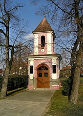
- chapel


