Seeleiten tower hill
| Seeleiten tower hill | ||
|---|---|---|
|
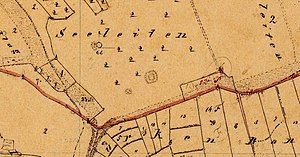
The castle site on an enlarged section of the Bavarian premiere (1808 to 1864) |
||
| Creation time : | Medieval | |
| Castle type : | Niederungsburg, moth | |
| Conservation status: | Departed, tower hill leveled | |
| Place: | Schönbrunn im Steigerwald - Frensdorf - "Seeleiten" | |
| Geographical location | 49 ° 52 '8.8 " N , 10 ° 43' 21.4" E | |
| Height: | 325 m above sea level NHN | |
|
|
||
The Tower Hill Seeleiten is an Outbound medieval motte (Motte) in the hallway Seeleiten, approximately 535 meters south-southeast of the town chapel of the village of Frensdorf , in the municipality of Schönbrunn im Steigerwald in the district of Bamberg in Bavaria , Germany . No historical or archaeological information is known about this Niederungsburg , it is roughly dated to medieval times. Since the tower hill is in agricultural land, it has now been completely leveled. The site is protected as a ground monument number D-4-6130-0041: leveled medieval tower hill .
description
The former castle site is about 525 m above sea level. NN height at the foot of a mountain slope sloping slightly south into the brook valley of a tributary of the Diedenbachl. The tower hill is around ten meters above the valley floor and 35 meters from the stream. It is not particularly protected on either side by nature. The site of the castle in the Seeleite corridor is used for agriculture today, which is why it has been completely leveled.
The layout of the complex can be found in the oldest cadastral edition. Accordingly, the square tower hill had a side length of around ten meters and was surrounded by a moat . The diameter of the tower hill and moat was around 25 meters together.
literature
- Klaus Schwarz: The prehistoric and early historical monuments in Upper Franconia . (Material booklets on Bavarian prehistory, series B, volume 5). Verlag Michael Laßleben , Kallmünz 1955, p. 49.
Individual evidence
- ^ Bavarian State Office for Monument Preservation
- ↑ List of monuments for Schönbrunn im Steigerwald (PDF) at the Bavarian State Office for Monument Preservation (PDF; 129 kB)
- ↑ Location of the tower hill in the Bavarian Monument Atlas
- ↑ Source description: Klaus Schwarz: The prehistoric and early historical terrain monuments of Upper Franconia , p. 49


