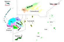
Administrative division of Fiji
The Republic of Fiji is divided into four divisions ( divisions ) (Central, Northern, Eastern, Western) and one dependent territory ( dependency ) (Rotuma) divided. The divisions are made up of several provinces (yasana), a total of 14 in number (excluding Rotuma). Below the provinces there are three traditional levels of rulership:
- Districts ( Tikina Cokavata )
- Sub-districts ( Tikina Vou )
- Villages ( Koro )
A first official census took place in 1881 with the result of 127,486 counted inhabitants, the last census took place in 2007 with the result of 837,271 inhabitants.
| Division (capital) |
Province (capital) |
Area km² |
Population 2007 |
|---|---|---|---|
|
Central ( Suva ) |
Naitasiri ( Vunidawa ) | 1,666 | 160,760 |
| Namosi ( Namosi ) | 570 | 6,898 | |
| Rewa ( Suva ) | 272 | 100,787 | |
| Serua ( Navua ) | 830 | 18,249 | |
| Tailevu ( Nausori ) | 955 | 55,692 | |
|
Northern ( Labasa ) |
Bua ( Nabouwalu ) | 1,379 | 14,176 |
| Cakaudrove ( Savusavu ) | 2,816 | 49,344 | |
| Macuata ( Labasa ) | 2,004 | 72,441 | |
|
Eastern ( Levuka ) |
Kadavu ( Vunisea ) | 478 | 10.167 |
| Lau ( Lakeba ) | 487 | 10,683 | |
| Lomaiviti ( Levuka ) | 411 | 16,461 | |
|
Western ( Lautoka ) |
Ba ( Lautoka ) | 2,634 | 231.760 |
| Nadroga-Navosa ( Sigatoka ) | 2,385 | 58,387 | |
| Ra ( rakiraki ) | 1,341 | 29,464 | |
| Rotuma ( Ahau ) | 46 | 2.002 | |
literature
- Country paper: Fiji . In: United Nations Economic and Social Commission for Asia and the Pacific UN ESCAP (Ed.): Local Government in Asia and the Pacific: A Comparative Study . Brief Description of the Country and its National / State Government Structure –Fijian administration ( web document ( Memento of November 3, 2013 in the Internet Archive )).
Web links
- Fiji Islands Bureau of Statistics: 2007 Census of Population and Housing . (= Statistical News. No. 45, October 15, 2008). (PDF; 314 KB) (English)
Individual evidence
- ↑ Fiji Islands Bureau of Statistics: 2007 Census of Population and Housing , p. 8 ( Memento of the original from January 5, 2011 in the Internet Archive ) Info: The archive link was inserted automatically and has not yet been checked. Please check the original and archive link according to the instructions and then remove this notice. , English, accessed April 15, 2013.

