Weißenborn (Gleichen)
|
Weissenborn
Unified community equals
|
|
|---|---|
| Coordinates: 51 ° 26 ′ 23 " N , 10 ° 7 ′ 43" E | |
| Residents : | 246 (May 4, 2015) |
| Incorporation : | 1st January 1973 |
| Postal code : | 37130 |
| Area code : | 05508 |
|
The district of Weißenborn is located in the southeastern area of the municipality of Gleichen
|
|
Weißenborn is a district of the municipality of Gleichen in the district of Göttingen in southern Lower Saxony with 246 inhabitants (as of May 4, 2015).
Geographical location
Weißenborn is located about 15 kilometers southeast of Göttingen, directly on the former inner-German border and today's Lower Saxony- Thuringia border. The location is in the upper Gartetal in the red sandstone landscape of the Eichsfeld hill country . The headwaters of the garden are located in the eastern part of the municipality. The highest point is a shell limestone ridge (up to 340 m) east and south of the village with the Hopfenberg . The small settlement of Charlottenburg to the north is also counted as part of the town.
Neighboring towns are the districts of Bischhausen in the west, Beienrode in the north and the Eichsfeld towns of Glasehausen in the east and Siemerode in the south , which also belong to the municipality of Gleichen .

history
From 1897 to 1931 Weißenborn owned a station on the narrow-gauge Gartetalbahn .
In the course of the municipal reform, Weißenborn became a part of the newly formed municipality Gleichen on January 1, 1973.
politics
Local council
The local council consists of five councilors and councilors.
- Weissenborn voter community: 5 seats
(As of: local election on September 11, 2011 )
Local mayor
The local mayor of Weißenborn is Gudrun Glahn.
coat of arms
| Blazon : "In silver (white) over a green hill, this is covered with a silver (white) wave pole growing from the base of the shield, which is bordered by a ring-shaped (stone-set) silver (white) wall, a silver (white) Linden tree. " | |
| Justification of the coat of arms: The coat of arms designed by Otto Rössler von Wildenhain was approved by the Lower Saxony Ministry of the Interior on February 16, 1950. It is reminiscent of the spring of the garden , which rises on a lime tree slope and is located in the municipality; at the same time it stands talking (Weißenborn = white source) for the place name. The linden tree also symbolizes the place as a former courtroom . |
Attractions
Ev. St. Nikolai Church
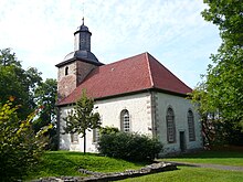
The Evangelical Church of St. Nikolai stands on a hill. There is also a fortified cemetery, the wall of which is partially present. The west tower of the medieval church has been preserved. The portal dates back to 1740. The plastered quarry stone hall with a wooden barrel vault was added at this time . The former pulpit altar , from which the pulpit basket has been removed, probably dates from 1756. The location of the church also shows signs of a fortified church . There is a former loopholes in the south. The brickwork on the tower and nave is about 1.20 m to 1.40 m thick. The upper, 2.5 m high, massive end of the church tower dates back to 1681. An earlier bell was withdrawn for war purposes because of the First World War in 1917, on it was the inscription for the community of Weißenborn cast by Heinrich Gabel in Freienhagen 1859, when Carl Stephan pastor, Carl Luetge teacher, Rohmann, Hille, Luthin and Aschoff were church leaders. The bell that was used later contained the words JACOB-PAPPE-IN-ERFFORT-ANNO-1-6-8-0 GOS-MICH . An inscription on the south side of the interior of the church indicates the fall of the south wall in 1681 and the obligation of Karl and Friedrich Goertz to rebuild the church with the help of two others.
- The Thieplatz in the village center.
- To the south of the former inner-German border, a wayside shrine and memorial stone were erected in thanks to the opening of the border in 1990 .
Web links
Individual evidence
- ↑ a b residents of the municipality of Gleichen (as of May 4, 2015), accessed on March 3, 2016
- ↑ Law on the reorganization of the municipalities in the Göttingen district, November 20, 1972 (PDF; 16 kB)
- ↑ http://wahlen.kds.de/2011kw/Daten/152011_000065/index.html
- ↑ Local councils of the municipality of Gleichen, accessed on December 24, 2016 (PDF)
- ^ Göttingen district archive, coats of arms of the localities of the municipality of Gleichen and their descriptions, email from April 24, 2019, municipality of Gleichen
- ↑ WEISSENBORN Gem. Gleichen, Kr. Göttingen. Ev. St. Nicolai Church. In: Georg Dehio : Handbook of German Art Monuments . Bremen Lower Saxony. Deutscher Kunstverlag, Munich / Berlin 1992, ISBN 3-422-03022-0 , page 1339
- ↑ Heinrich Lücke: On the banks of the garden. History and literature from the southeast corner of the Göttingen region . Mecke, Duderstadt 1927, p. 138 .


