Wittig (river)
|
Wittig Witka, Smědá |
||
| Data | ||
| Water code | CZ : 2-04-10-001 | |
| location | Czech Republic and Poland | |
| River system | Or | |
| Drain over | Lusatian Neisse → Oder → Baltic Sea | |
| source | am Wittighaus, Jizera Mountains , Czech Republic 50 ° 50 ′ 36 ″ N , 15 ° 16 ′ 27 ″ E |
|
| Source height | 847 m nm | |
| muzzle | near Radomierzyce , Poland in the Lusatian Neisse Coordinates: 51 ° 2 '59 " N , 14 ° 57' 52" E 51 ° 2 '59 " N , 14 ° 57' 52" E |
|
| Mouth height | approx. 195 m npm | |
| Height difference | approx. 652 m | |
| Bottom slope | approx. 13 ‰ | |
| length | 51.9 km | |
| Catchment area | 331 km² | |
| Left tributaries | Bílý potok , Černý potok , Sloupský potok , Holubí potok , Pustý potok | |
| Right tributaries | Hájený potok , Libverdský potok , Pekelský potok , Lomnice , Řasnice , Bulovský potok , Koci Potok | |
| Reservoirs flowed through | Niedów Reservoir | |
|
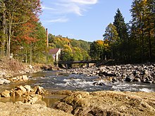
The Wittig near Ves in the Czech Republic . |
||

The Wittig ( Czech Smědá , Polish Witka ) is a right tributary of the Lusatian Neisse in the Czech Republic and Poland .
course
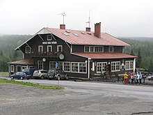
The Wittig arises at the Wittighaus ( Horská chata Smědava ) in the Czech Jizera Mountains at 847 m altitude through the confluence of three source streams.
- The White Wittig (Bílá Smědá) rises at an altitude of almost 1000 m above sea level. in the Klečové louky bog between the Jizera ( Siechhübel , 1122 m) and the Smědavská hora ( Wittigberg , 1084 m).
- The Black Wittig (Černá Smědá) arises in the Černá jezírka moor on the Předěl.
- The brown Wittig ( Hnědá Smědá ) has its origin at the eastern foot of the Jizera in the Louka u Studánky bog, where the black Desse ( Černá Desná ) also rises.
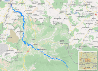
The Wittig flows from the Wittighaus with a steep gradient to Bílý Potok ( German Weißbach ). On its way to the northwest, the Wittig touches the towns of Hejnice ( Haindorf ), Raspenava ( Raspenau ) and Frýdlant v Čechách ( Friedland ). The uneven river course between Předlánce and Černousy is protected as a nature reserve Meandry Smědé . At the village of Ves ( meadow ) it leaves the Bohemian area in 209 m nm and flows into the Polish Upper Lusatia . The Czech part has a length of 45.9 km, the catchment area there covers 273.8 km². The mean discharge MQ at the border is 3.61 m³ / s.
At Niedów ( Nieda ) the Wittig was dammed in the Niedów reservoir . This dam with a water surface of 176 hectares and a storage height of 11 m was created between 1958 and 1962 as a water reservoir for the Turów power plant and was used for recreational purposes. However, the water was heavily clouded by discharges from the spring moor and by the pollution of the neighboring towns and villages.
At Joachimstein Abbey in Radomierzyce ( Radmeritz ) the Wittig flows into the Lusatian Neisse.
history
According to the Vienna Treaty of 1815, the Wittig formed the border between the Saxon and Prussian parts of Upper Lusatia , i.e. the border between Saxony and Silesia . Until 1871, east of Wanscha (Spytków) was the triangle between the kingdoms of Saxony and Prussia and the Austrian Empire . After the end of the Second World War , the German section of the Wittig to Poland came in 1945 when the German-Polish border was moved to the Neisse. In the course of the construction of the Niedów reservoir, the border between Poland and Czechoslovakia was regulated in the 1950s. The uninhabited tip of land belonging to Ves to the left of the Wittig, which protruded into the Polish area between Spytków and the Zawidów ( Seidenberg ) train station as far as Wilka , was ceded to Poland and later largely flooded. The course of the brook Boreček and the Wittig were set as the new state border.
The former cosmopolitan Fräuleinstift Joachimstein is located on an artificially created island in the area where the Wittig flows into the Neisse . The monastery, which belonged to Saxony until 1945 and since then to Poland, enjoyed a special status. Unused after 1945, the buildings fell into disrepair and have been renovated since 2003.
On August 7, 2010, after heavy rainfall, the dam broke and caused a tidal wave into the Neisse.
Tributaries
- Šindelový potok (r), on Předěl
- Hájený potok (r), Bílý Potok
- Velká rybí voda (r), Bílý Potok
- Bílý potok (l), Bílý Potok
- Černý potok (l), Hejnice
- Libverdský potok (r), Lužec
- Sloupský potok (l), Raspenava
- Pekelský potok (r), Luh
- Holubí potok (l), Raspenava
- Lomnice (r), Luh
- Pustý potok (l), Raspenava
- Větrovský potok (l), Větrov
- Řasnice (r), Frýdlant
- Kunratický potok (l), Kunratice
- Krčelický potok (r), Víska
- Minkovický potok (l), Minkovice
- Višňovský potok (l), Předlánce
- Bulovský potok (r), Předlánce
- Saňský potok (l), Filipovka
- Boreček or Andělský potok / Boreczek (l), Ves
- Kočičí potok / Koci Potok (r), Niedów reservoir
Web links
Individual evidence
- ↑ http://www.kraj-lbc.cz/public/ozivpr/priloha_c_1_text_koncepce_0ba3566a3f.pdf ( Memento from April 7, 2014 in the Internet Archive )
- ↑ Der Tagesspiegel: Deaths and disaster alarms during floods in Saxony , accessed on August 8, 2010.


