
Wylok
| Wylok | |||
| Вилок | |||

|
|
||
| Basic data | |||
|---|---|---|---|
| Oblast : | Zakarpattia Oblast | ||
| Rajon : | Vynohradiv district | ||
| Height : | 117 m | ||
| Area : | 8.35 km² | ||
| Residents : | 3,422 (December 2004) | ||
| Population density : | 410 inhabitants per km² | ||
| Postcodes : | 90351 | ||
| Area code : | +380 3143 | ||
| Geographic location : | 48 ° 6 ' N , 22 ° 50' E | ||
| KOATUU : | 2121255300 | ||
| Administrative structure : | 1 urban-type settlement | ||
| Mayor : | Jossyp Kilb | ||
| Address: | вул. Гагаріна 4 90351 смт. Вилок |
||
| Statistical information | |||
|
|||


Vylok (Ukrainian Вилок ; Russian Wilok , Slovak Vylok , Hungarian Tiszaújlak ) is an urban-type settlement in the Western Ukraine ( Zakarpattia Oblast , Vynohradiv Raion ) about 17 kilometers southwest of the town of Vynohradiv and 21 kilometers southeast of the town of Berehove .
The village with around 3400 inhabitants (90 percent Hungarian-speaking) is located in the Transcarpathian lowlands on the banks of the Tisza, opposite the Hungarian municipality of Tiszabecs . There is a border crossing to Hungary to the south of the village .
history
The place was first mentioned in writing as Wylak in 1304 . In 1657 it was devastated by the Poles and in 1661 by the Tatars. In 1910 the place in the Kingdom of Hungary in Ung County had 3,470 inhabitants, 3,411 of whom were Hungarians. After the end of the First World War it came to the newly formed Czechoslovakia (as part of the Carpathian Ukraine ) and was ceded to the USSR after the end of the Second World War . In 1959 the place received the status of an urban-type settlement .
Attractions
- a Turul monument, erected in 1903
- Roman Catholic Church from 1788, consecrated to Saint Helena
- Greek Catholic Church from 1806 in the classical style
- Reformed church from 1727, rebuilt in 1859
gallery
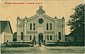
The synagogue
_synagogue.jpg)
Berehove | Chust | Irshava | Mukachevo | Perechyn | Rakhiv | Svyava | Tyachiv | Tschop | Uzhhorod | Vynohradiv
Batjowo urban-type settlements |
Bushhtyno |
Dubowe |
Yasinja |
Kobylezka Polyana |
Kolchyno |
Korolewo |
Mishhirja |
Serednje |
Shdeniyevo |
Zolotvyno |
Tereswa |
Chynadiyovo |
Ust-Chorna |
Velykyj Bereznyj |
Velykyi Bychkiv |
Volovets |
Wylok |
Vyshkovo