Zemplínska Nová Ves: Difference between revisions
Content deleted Content added
Replacing geodata: {{coord|48|34|N|21|40|E|region:SK_type:city|display=title}} |
m robot Adding: eo:Zemplínska Nová Ves |
||
| Line 27: | Line 27: | ||
{{coord|48|34|N|21|40|E|region:SK_type:city|display=title}} |
{{coord|48|34|N|21|40|E|region:SK_type:city|display=title}} |
||
[[Category:Villages and municipalities in Trebišov District]] |
[[Category:Villages and municipalities in Trebišov District]] |
||
[[eo:Zemplínska Nová Ves]] |
|||
[[hu:Zemplénújfalu]] |
[[hu:Zemplénújfalu]] |
||
[[sk:Zemplínska Nová Ves]] |
[[sk:Zemplínska Nová Ves]] |
||
Revision as of 07:20, 12 November 2008

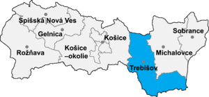
Zemplínska Nová Ves is a village and municipality in the Trebišov District in the Košice Region of south-eastern Slovakia. The village consist of parts: the first named Úpor and the second which name is Zemplinský Klečenov.
History
In historical records the village was first mentioned in 1263.
Geography
The village lies at an altitude of 129 metres and covers an area of 10.704 km². It has a population of about 952 people.
Ethnicity
The village is about 98% Slovak
Facilities
The village has a public library and a football pitch.
External links
