
Lanzuela: Difference between revisions
Content deleted Content added
m r2.6.4) (robot Adding: uk:Лансуела |
wikified |
||
| Line 1: | Line 1: | ||
{{Infobox City |
{{Infobox City |
||
|official_name = Lanzuela |
|official_name = Lanzuela |
||
|nickname = |
|nickname = |
||
|image_flag = |
|image_flag = |
||
| Line 6: | Line 6: | ||
|image_map = |
|image_map = |
||
|map_caption = |
|map_caption = |
||
|pushpin_map = |
|pushpin_map = Spain |
||
|pushpin_label_position = |
|pushpin_label_position = |
||
|pushpin_map_caption = |
|pushpin_map_caption = |
||
|coordinates_display = display=inline,title |
|coordinates_display = display=inline,title |
||
| Line 19: | Line 19: | ||
|subdivision_type2 = [[Provinces of Spain|Province]] |
|subdivision_type2 = [[Provinces of Spain|Province]] |
||
|subdivision_name2 = [[Teruel (province)|Teruel]] |
|subdivision_name2 = [[Teruel (province)|Teruel]] |
||
|subdivision_type3 = [[Comarcas of Aragon|Comarca]] |
|subdivision_type3 = [[Comarcas of Aragon|Comarca]] |
||
|subdivision_name3 = [[Jiloca Comarca|Jiloca]] |
|subdivision_name3 = [[Jiloca Comarca|Jiloca]] |
||
|leader_title = |
|leader_title = |
||
| Line 42: | Line 42: | ||
}} |
}} |
||
'''Lanzuela''' is a municipality located in the [[Teruel (province)|province of Teruel]], [[Aragon]], [[Spain]]. According to the |
'''Lanzuela''' is a municipality located in the [[Teruel (province)|province of Teruel]], [[Aragon]], [[Spain]]. According to the 2010 [[census]] the municipality has a population of 102 inhabitants.<ref>[[Instituto Nacional de Estadística (Spain)]]</ref> |
||
Lanzuela is located at the western end of the [[Sierra de Cucalón]] area. There are two shrines ''(ermitas)'' in the town, the ''Ermita de Jesús Nazareno'' and the ''Ermita de Santa Bárbara'', built in the 18th century. |
|||
==Gallery== |
|||
<gallery> |
|||
File:Lanzuela37.JPG|View of Lanzuela |
|||
File:La Modorra34.JPG|La Modorra, highest point in the [[Sierra de Cucalón]] system seen from near Lanzuela |
|||
</gallery> |
|||
==See also== |
==See also== |
||
*[[Jiloca Comarca]] |
*[[Jiloca Comarca]] |
||
*[[List of municipalities in Teruel]] |
|||
==References== |
|||
{{reflist}} |
|||
== External links == |
|||
{{commonscat}} |
|||
*[http://www.caiaragon.com/es/municipios/index.asp?idloc=309&tipo=0 CAI Aragon - Lanzuela] |
|||
*[http://www.xiloca.com/xilocapedia/index.php?title=Sierra_de_Cucal%C3%B3n Sierra de Cucalón] |
|||
*[http://www.xiloca.com/data/Bases%20datos/Varios/Fonfria.pdf Guía general de las sierras de Cucalón, Oriche y Fonfría] |
|||
{{Municipalities in Teruel}} |
{{Municipalities in Teruel}} |
||
Revision as of 12:41, 24 June 2011
Lanzuela | |
|---|---|
| Country | Spain |
| Autonomous community | Aragon |
| Province | Teruel |
| Comarca | Jiloca |
| Area | |
| • Total | 14 km2 (5 sq mi) |
| Population (2004) | |
| • Total | 31 |
| • Density | 2.2/km2 (6/sq mi) |
| Time zone | UTC+1 (CET) |
| • Summer (DST) | UTC+2 (CEST) |
Lanzuela is a municipality located in the province of Teruel, Aragon, Spain. According to the 2010 census the municipality has a population of 102 inhabitants.[1]
Lanzuela is located at the western end of the Sierra de Cucalón area. There are two shrines (ermitas) in the town, the Ermita de Jesús Nazareno and the Ermita de Santa Bárbara, built in the 18th century.
Gallery
-
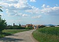 View of Lanzuela
 -
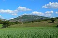 La Modorra, highest point in the Sierra de Cucalón system seen from near Lanzuela


See also
References
External links
Wikimedia Commons has media related to Lanzuela.
This article about a location in Aragon, Spain, is a stub. You can help Wikipedia by expanding it. |