Otanche: Difference between revisions
Content deleted Content added
m Reverted edits by The Anomebot2 (talk) to last version by Picapica |
→Climate: add brief description |
||
| (41 intermediate revisions by 33 users not shown) | |||
| Line 1: | Line 1: | ||
{{Infobox settlement |
|||
'''Otanche''' is a [[municipio|municipality]] in [[Boyacá Department]], [[Colombia]]. |
|||
<!-- See Template:Infobox settlement for additional fields and descriptions --> |
|||
|name = Otanche |
|||
|native_name = |
|||
|nickname = |
|||
|motto = |
|||
|settlement_type = [[Municipalities of Colombia|Municipality]] and town |
|||
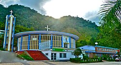
|image_skyline = Iglesia María del Carmen de Otanche, Boyacá (por Francisco Foster).jpg |
|||
|imagesize = |
|||
|image_caption = |
|||
|image_flag = Flag of Otanche (Boyacá).svg |
|||
|image_seal = |
|||
|image_map = Colombia - Boyaca - Otanche.svg |
|||
|mapsize = 250px |
|||
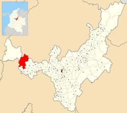
|map_caption = Location of the municipality and town of Otanche in the Boyacá Department of Colombia. |
|||
|pushpin_map = |
|||
|pushpin_mapsize = 300 |
|||
|pushpin_map_caption = Location in Colombia |
|||
|subdivision_type = Country |
|||
|subdivision_name = {{flag|Colombia}} |
|||
|subdivision_type1 = [[Departments of Colombia|Department]] |
|||
|subdivision_name1 = [[Boyacá Department]] |
|||
|subdivision_type2 = Province |
|||
|subdivision_name2 = [[Western Boyacá Province]] |
|||
|leader_title = Mayor |
|||
|leader_name = Evelio Puentes Rocha<br>{{Small|(2020-2023)}} |
|||
|established_title = |
|||
|established_date = |
|||
|area_magnitude = |
|||
|area_total_km2 = |
|||
|area_total_sq_mi = |
|||
|area_land_km2 = |
|||
|area_land_sq_mi = |
|||
|area_water_km2 = |
|||
|area_water_sq_mi = |
|||
|area_water_percent = |
|||
|area_urban_km2 = |
|||
|area_urban_sq_mi = |
|||
|area_metro_km2 = |
|||
|area_metro_sq_mi = |
|||
|population_as_of = Census 2018<ref name="Censo">{{cite web|url=https://sitios.dane.gov.co/cnpv/#!/ |title=Censo Nacional de Población y Vivienda 2018|publisher=[[Departamento Administrativo Nacional de Estadística |DANE]]|lang=es |access-date=7 May 2020}}</ref> |
|||
|population_note = |
|||
|population_total = 6997 |
|||
|population_density_km2 = |
|||
|population_density_sq_mi = |
|||
|population_metro = |
|||
|population_density_metro_km2 = |
|||
|population_density_metro_sq_mi = |
|||
|population_urban = |
|||
|coordinates = |
|||
|timezone = Colombia Standard Time |
|||
|utc_offset = -5 |
|||
|timezone_DST = |
|||
|utc_offset_DST = |
|||
|elevation_m = |
|||
|elevation_ft = |
|||
|website = |
|||
|footnotes = |
|||
}} |
|||
'''Otanche''' is a town and [[Municipalities of Colombia|municipality]] in [[Boyacá Department]], [[Colombia]], part of the subregion of the [[Western Boyacá Province]]. |
|||
[[Category:Municipalities of Boyacá]] |
|||
==Climate== |
|||
Otanche has a [[tropical rainforest climate]] ([[Köppen climate classification|Köppen]]: ''Aw'')<ref>{{Cite journal |date=23 October 2023 |title=Table 1 Overview of the Köppen-Geiger climate classes including the defining criteria. |url=https://www.nature.com/articles/s41597-023-02549-6/tables/1 |journal=Nature: Scientific Data |language=en}}</ref> with mild temperatures and high amounts of rainfall throughout the year. |
|||
{{Weather box |
|||
{{Colombia-geo-stub}} |
|||
| width = auto |
|||
| collapsed = yes |
|||
| metric first = yes |
|||
| single line = yes |
|||
| location = Otanche (1991–2020) |
|||
| Jan high C = 26.17 |
|||
| Feb high C = 26.35 |
|||
| Mar high C = 26.25 |
|||
| Apr high C = 26.53 |
|||
| May high C = 26.67 |
|||
| Jun high C = 26.83 |
|||
| Jul high C = 27.0 |
|||
| Aug high C = 27.29 |
|||
| Sep high C = 27.08 |
|||
| Oct high C = 26.34 |
|||
| Nov high C = 25.92 |
|||
| Dec high C = 25.96 |
|||
| year high C = 26.53 |
|||
| Jan low C = 18.7 |
|||
| Feb low C = 18.89 |
|||
| Mar low C = 18.91 |
|||
| Apr low C = 18.89 |
|||
| May low C = 19.03 |
|||
| Jun low C = 18.79 |
|||
| Jul low C = 18.62 |
|||
| Aug low C = 18.78 |
|||
| Sep low C = 18.54 |
|||
| Oct low C = 18.62 |
|||
| Nov low C = 18.57 |
|||
| Dec low C = 18.72 |
|||
| year low C = 18.76 |
|||
| precipitation colour = green |
|||
| Jan precipitation mm = 190.12 |
|||
| Feb precipitation mm = 206.87 |
|||
| Mar precipitation mm = 315.36 |
|||
| Apr precipitation mm = 385.79 |
|||
| May precipitation mm = 359.61 |
|||
| Jun precipitation mm = 208.83 |
|||
| Jul precipitation mm = 180.54 |
|||
| Aug precipitation mm = 194.06 |
|||
| Sep precipitation mm = 252.19 |
|||
| Oct precipitation mm = 448.11 |
|||
| Nov precipitation mm = 383.45 |
|||
| Dec precipitation mm = 235.56 |
|||
| year precipitation mm = 3360.48 |
|||
| unit precipitation days = 1.0 mm |
|||
| Jan precipitation days = 13.12 |
|||
| Feb precipitation days = 13.47 |
|||
| Mar precipitation days = 18.84 |
|||
| Apr precipitation days = 19.68 |
|||
| May precipitation days = 20.5 |
|||
| Jun precipitation days = 14.7 |
|||
| Jul precipitation days = 14.36 |
|||
| Aug precipitation days = 13.62 |
|||
| Sep precipitation days = 15.91 |
|||
| Oct precipitation days = 20.43 |
|||
| Nov precipitation days = 20.9 |
|||
| Dec precipitation days = 15.56 |
|||
| year precipitation days = 201.09 |
|||
| source 1 = [[National Oceanic and Atmospheric Administration|NOAA]]<ref name="WMONormals">{{cite web |
|||
|url = https://www.nodc.noaa.gov/archive/arc0216/0253808/2.2/data/0-data/Region-3-WMO-Normals-9120/Colombia/CSV/Otanche_23125080.csv |
|||
|title = World Meteorological Organization Climate Normals for 1991-2020 — Otanche |
|||
|publisher = National Oceanic and Atmospheric Administration |
|||
|access-date = January 25, 2024}}</ref> |
|||
}} |
|||
==References== |
|||
{{reflist}} |
|||
{{commonscat|Otanche}} |
|||
{{coord|5|45|N|74|15|W|region:CO_type:adm2nd_source:GNS-enwiki|display=title}} |
|||
{{Municipalities boyaca department}} |
|||
{{Mining in Colombia}} |
|||
{{Colombian emeralds|state=expanded}} |
|||
[[Category:Municipalities of Boyacá Department]] |
|||
{{Boyacá-geo-stub}} |
|||
Latest revision as of 06:23, 26 January 2024
Otanche | |
|---|---|
Municipality and town | |
 | |
 Location of the municipality and town of Otanche in the Boyacá Department of Colombia. | |
| Country | |
| Department | Boyacá Department |
| Province | Western Boyacá Province |
| Government | |
| • Mayor | Evelio Puentes Rocha (2020-2023) |
| Population (Census 2018[1]) | |
| • Total | 6,997 |
| Time zone | UTC-5 (Colombia Standard Time) |
Otanche is a town and municipality in Boyacá Department, Colombia, part of the subregion of the Western Boyacá Province.
Climate[edit]
Otanche has a tropical rainforest climate (Köppen: Aw)[2] with mild temperatures and high amounts of rainfall throughout the year.
| Climate data for Otanche (1991–2020) | |||||||||||||
|---|---|---|---|---|---|---|---|---|---|---|---|---|---|
| Month | Jan | Feb | Mar | Apr | May | Jun | Jul | Aug | Sep | Oct | Nov | Dec | Year |
| Mean daily maximum °C (°F) | 26.17 (79.11) |
26.35 (79.43) |
26.25 (79.25) |
26.53 (79.75) |
26.67 (80.01) |
26.83 (80.29) |
27.0 (80.6) |
27.29 (81.12) |
27.08 (80.74) |
26.34 (79.41) |
25.92 (78.66) |
25.96 (78.73) |
26.53 (79.75) |
| Mean daily minimum °C (°F) | 18.7 (65.7) |
18.89 (66.00) |
18.91 (66.04) |
18.89 (66.00) |
19.03 (66.25) |
18.79 (65.82) |
18.62 (65.52) |
18.78 (65.80) |
18.54 (65.37) |
18.62 (65.52) |
18.57 (65.43) |
18.72 (65.70) |
18.76 (65.77) |
| Average precipitation mm (inches) | 190.12 (7.49) |
206.87 (8.14) |
315.36 (12.42) |
385.79 (15.19) |
359.61 (14.16) |
208.83 (8.22) |
180.54 (7.11) |
194.06 (7.64) |
252.19 (9.93) |
448.11 (17.64) |
383.45 (15.10) |
235.56 (9.27) |
3,360.48 (132.30) |
| Average precipitation days (≥ 1.0 mm) | 13.12 | 13.47 | 18.84 | 19.68 | 20.5 | 14.7 | 14.36 | 13.62 | 15.91 | 20.43 | 20.9 | 15.56 | 201.09 |
| Source: NOAA[3] | |||||||||||||
References[edit]
- ^ "Censo Nacional de Población y Vivienda 2018" (in Spanish). DANE. Retrieved 7 May 2020.
- ^ "Table 1 Overview of the Köppen-Geiger climate classes including the defining criteria". Nature: Scientific Data. 23 October 2023.
- ^ "World Meteorological Organization Climate Normals for 1991-2020 — Otanche". National Oceanic and Atmospheric Administration. Retrieved January 25, 2024.
Wikimedia Commons has media related to Otanche.
5°45′N 74°15′W / 5.750°N 74.250°W


