
Zaječov: Difference between revisions
Content deleted Content added
population, parts, history |
population, infobox |
||
| Line 1: | Line 1: | ||
{{Infobox settlement |
{{Infobox settlement |
||
| name = Zaječov |
| name = Zaječov |
||
| native_name = |
|||
| other_name = |
| other_name = |
||
| settlement_type = [[Obec|Municipality]] |
| settlement_type = [[Obec|Municipality]] |
||
| Line 9: | Line 8: | ||
| image_flag = Zaječov BE CZ flag.svg |
| image_flag = Zaječov BE CZ flag.svg |
||
| image_shield = Zajecov znak.gif |
| image_shield = Zajecov znak.gif |
||
| etymology = |
|||
<!-- location --> |
<!-- location --> |
||
| subdivision_type = Country |
| subdivision_type = Country |
||
| Line 38: | Line 36: | ||
| elevation_m = 458 |
| elevation_m = 458 |
||
<!-- population --> |
<!-- population --> |
||
| population_as_of = |
| population_as_of = 2022-01-01 |
||
| population_footnotes = <ref>{{cite web |title=Population of Municipalities – 1 January |
| population_footnotes = <ref>{{cite web |title=Population of Municipalities – 1 January 2022|url=https://www.czso.cz/csu/czso/population-of-municipalities-1-january-2022|publisher=[[Czech Statistical Office]]|date=2022-04-29}}</ref> |
||
| population_total = |
| population_total = 1435 |
||
| population_density_km2 = auto |
| population_density_km2 = auto |
||
<!-- time zone(s) --> |
<!-- time zone(s) --> |
||
| Line 56: | Line 54: | ||
| footnotes = |
| footnotes = |
||
}} |
}} |
||
'''Zaječov''' is a municipality and village in [[Beroun District]] in the [[Central Bohemian Region]] of the [[Czech Republic]]. It has about 1,400 inhabitants. |
'''Zaječov''' is a municipality and village in [[Beroun District]] in the [[Central Bohemian Region]] of the [[Czech Republic]]. It has about 1,400 inhabitants. |
||
Zaječov is located about {{convert|27|km|mi}} southwest of [[Beroun]] and {{convert|55|km|mi|abbr=on}} southwest of [[Prague]]. |
|||
==Administrative parts== |
==Administrative parts== |
||
| Line 74: | Line 74: | ||
{{reflist}} |
{{reflist}} |
||
{{ |
{{commons category|Zaječov}} |
||
{{Beroun District}} |
{{Beroun District}} |
||
| Line 83: | Line 83: | ||
{{ |
{{CentralBohemia-geo-stub}} |
||
Revision as of 13:12, 13 May 2022
Zaječov | |
|---|---|
 Monastery in Zaječov | |
 Flag  Coat of arms | |
 Zaječov Location in the Czech Republic | |
| Coordinates: 49°46′28″N 13°50′27″E / 49.77444°N 13.84083°E | |
| Country | |
| Region | Central Bohemian |
| District | Beroun |
| First mentioned | 1578 |
| Area | |
| • Total | 22.25 km2 (8.59 sq mi) |
| Elevation | 458 m (1,503 ft) |
| Population (2022-01-01)[1] | |
| • Total | 1,435 |
| • Density | 64/km2 (170/sq mi) |
| Time zone | UTC+1 (CET) |
| • Summer (DST) | UTC+2 (CEST) |
| Postal codes | 267 62, 267 63 |
| Website | www |
Zaječov is a municipality and village in Beroun District in the Central Bohemian Region of the Czech Republic. It has about 1,400 inhabitants.
Zaječov is located about 27 kilometres (17 mi) southwest of Beroun and 55 km (34 mi) southwest of Prague.
Administrative parts
Villages of Kvaň and Nová Ves are administrative parts of Zaječov.
History
The first written mention of Zaječov is from 1578. On 1 January 1976, municipalities of Zaječov and Kvaň were merged.[2]
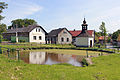
Gallery
-
 Upper common
 -
 Lower common
 -
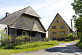 Local part Kvaň


References
- ^ "Population of Municipalities – 1 January 2022". Czech Statistical Office. 2022-04-29.
- ^ "Historie obce" (in Czech). Obec Zaječov. Retrieved 2021-07-03.
Wikimedia Commons has media related to Zaječov.
| International | |
|---|---|
| National | |
This Central Bohemian Region location article is a stub. You can help Wikipedia by expanding it. |