
Zaječov: Difference between revisions
Content deleted Content added
+pop, area |
+img |
||
| Line 8: | Line 8: | ||
|motto = |
|motto = |
||
<!-- images and maps -----------> |
<!-- images and maps -----------> |
||
|image_skyline = |
|image_skyline = Zaječov, monastery.jpg |
||
|imagesize = |
|imagesize = |
||
|image_caption = |
|image_caption = Monastery in Zaječov |
||
|image_flag = Zaječov BE CZ flag.svg |
|image_flag = Zaječov BE CZ flag.svg |
||
|flag_size = |
|flag_size = |
||
| Line 79: | Line 79: | ||
}} |
}} |
||
'''Zaječov''' is a village and municipality in [[Beroun District]] in the [[Central Bohemian Region]] of the [[Czech Republic]]. The municipality covers an area of {{convert|7.03|km2|sqmi}} and as of 2006 it had a population of 1403. |
'''Zaječov''' is a village and municipality in [[Beroun District]] in the [[Central Bohemian Region]] of the [[Czech Republic]]. The municipality covers an area of {{convert|7.03|km2|sqmi}} and as of 2006 it had a population of 1403. |
||
== Gallery == |
|||
<gallery> |
|||
File:Zaječov, upper common.jpg| Upper common |
|||
File:Zaječov, lower common 2.jpg| Lower common |
|||
File:Zaječov, Kvaň, upper part 2.jpg| Local part Kvaň |
|||
</gallery> |
|||
==References== |
==References== |
||
*''This article was initially translated from the Czech Wikipedia.'' |
*''This article was initially translated from the Czech Wikipedia.'' |
||
{{Commonscat}} |
|||
{{Beroun District}} |
{{Beroun District}} |
||
Revision as of 19:16, 18 June 2013
You can help expand this article with text translated from the corresponding article in Czech. (July 2009) Click [show] for important translation instructions.
|
Zaječov | |
|---|---|
Municipality and village | |
 Monastery in Zaječov | |
 Flag  Coat of arms | |
 | |
| Country | |
| Region | Central Bohemian Region |
| District | Beroun District |
| Area | |
| • Total | 2.71 sq mi (7.03 km2) |
| Elevation | 1,503 ft (458 m) |
| Population (2011) | |
| • Total | 1,403 |
| • Density | 520/sq mi (200/km2) |
| Time zone | UTC+1 (CET) |
| • Summer (DST) | UTC+2 (CEST) |
Zaječov is a village and municipality in Beroun District in the Central Bohemian Region of the Czech Republic. The municipality covers an area of 7.03 square kilometres (2.71 sq mi) and as of 2006 it had a population of 1403.
Gallery
-
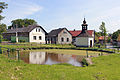 Upper common
 -
 Lower common
 -
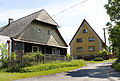 Local part Kvaň


References
- This article was initially translated from the Czech Wikipedia.
Wikimedia Commons has media related to Zaječov.
49°46′N 13°51′E / 49.767°N 13.850°E
Wikimedia Commons has media related to Zaječov.