
Zaječov
Zaječov | |
|---|---|
 Monastery in Zaječov | |
 Flag  Coat of arms | |
 Zaječov Location in the Czech Republic | |
| Coordinates: 49°46′28″N 13°50′27″E / 49.77444°N 13.84083°E | |
| Country | |
| Region | Central Bohemian |
| District | Beroun |
| First mentioned | 1578 |
| Area | |
| • Total | 22.25 km2 (8.59 sq mi) |
| Elevation | 458 m (1,503 ft) |
| Population (2020-01-01[1]) | |
| • Total | 1,436 |
| • Density | 65/km2 (170/sq mi) |
| Time zone | UTC+1 (CET) |
| • Summer (DST) | UTC+2 (CEST) |
| Postal code | 267 62, 267 63 |
| Website | www |
Zaječov is a municipality and village in Beroun District in the Central Bohemian Region of the Czech Republic. It has about 1,400 inhabitants. It is located 27 kilometres (17 mi) southwest of Beroun and 55 kilometres (34 mi) southwest of Prague.
History
First written notice about Zaječov is from year 1578.
Gallery
-
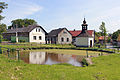 Upper common
 -
 Lower common
 -
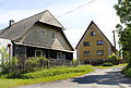 Local part Kvaň


References
- ^ "Population of Municipalities – 1 January 2020". Czech Statistical Office. 2020-04-30.
Wikimedia Commons has media related to Zaječov.
| International | |
|---|---|
| National | |