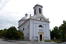
Čataj
| Čataj | ||
|---|---|---|
| coat of arms | map | |

|
|
|
| Basic data | ||
| State : | Slovakia | |
| Kraj : | Bratislavský kraj | |
| Okres : | Senec | |
| Region : | Bratislava | |
| Area : | 12.867 km² | |
| Residents : | 1,182 (Dec. 31, 2019) | |
| Population density : | 92 inhabitants per km² | |
| Height : | 140 m nm | |
| Postal code : | 900 83 | |
| Telephone code : | 0 2 | |
| Geographic location : | 48 ° 16 ' N , 17 ° 29' E | |
| License plate : | SC | |
| Kód obce : | 507865 | |
| structure | ||
| Community type : | local community | |
| Administration (as of November 2018) | ||
| Mayor : | Marta Tušová | |
| Address: | Obecný úrad Čataj Hlavná 333 90083 Čataj |
|
| Website: | www.cataj.sk | |
| Statistics information on statistics.sk | ||
Čataj (German Schattein , Hungarian Csataj ) is a municipality in Okres Senec within the Bratislavský kraj in Slovakia .
geography
The place is located in the Danube lowlands by the Vištucký creek , 10 km northeast of the city of Senec and 19 km southwest of Trnava .
history
In today's cadastral area, several finds from the Stone and Bronze Ages as well as from the time of Great Moravia were found . The place was first mentioned in writing in 1244 as villa Chatey and belonged to the local noble families. In the 14th century there was an influx of German colonists and from this time until the 18th century it belonged to the Counts of St. Georgen , then to the estate of royal silk .
Until 1918 the place was in Pressburg County in the Kingdom of Hungary , then it came to the newly formed Czechoslovakia .
Culture
- See also: List of listed objects in Čataj

