
Achtum-Uppen
|
Achtum-Uppen
City of Hildesheim
|
|
|---|---|
 |
|
| Height : | 117 m above sea level NHN |
| Area : | 8.63 km² |
| Residents : | 1189 (2019) |
| Population density : | 138 inhabitants / km² |
| Incorporation : | March 1, 1974 |
| Postal code : | 31135-31137 |
| Area code : | 05121 |
 Location of Achtum-Uppen in Hildesheim
|
|
Achtum-Uppen is a district of Hildesheim , which consists of two parts: the larger Achtum , four kilometers east of Hildesheim not far north of the federal highway B 6 , and the smaller Uppen , five kilometers east of Hildesheim on the federal highway 6.
history
The district of Achtum, a former clustered village , was mentioned for the first time as the eighth in a document in 1173 , when the tithe of the village was transferred to the Godehardikloster by Bishop Adelog. The village received its own church in 1195, before it belonged to the parish of St. Andreas in Hildesheim.
Uppen is the easternmost district of Hildesheim and was first mentioned in a document in 1125. When the Landwehr was built in the Middle Ages from 1429 to protect the city of Hildesheim and its fields, a tower and a passage, the so-called “Uppener Pass”, were built in Uppen. A street name, a memorial stone and a plaque in Uppen still remember him today. The tower of the Uppener Pass is also shown in the coat of arms of Achtum-Uppen.
Incorporations
The incorporation to Hildesheim took place for the regional reform in Lower Saxony on March 1, 1974.
Population development
|
|
¹ Census
² thereof 630 Catholic and 338 Protestant
³ as of December 31st
politics
Local council
The local council consists of four council women and three councilors. There are also eight advisory members in the local council ( SPD : 3, CDU: 2, Die Linke : 1, AfD : 1, Greens: 1).
(Status: local election September 11, 2016)
Local mayor
The local mayor is Henning Wittneben (CDU). His deputy is Anja Markwart (Greens).
coat of arms
|
|
Blazon : “ Shield split ; front:a black house brand in gold ; in: Rear red a silver tower with five battlements and four arrow slits , arranged 1/1/2 ". |
| Justification of the coat of arms: The coat of arms of Achtum-Uppen shows on the front side of the coat of arms the house brand of Heinrich von Uppen after his seal from 1374 on a document of the Godehardikloster. The rear symbolizes the old defense tower of St. Martin's Church from the 12th century. |
Culture and sights
Buildings
- A figure of the patron saint of Bohemia, Johannes Nepomuk , from the 18th century, which was previously set up outside the village in the field, has been on view on federal road 6 since 1984 .
- The historic rectory and the Catholic Church of St. Martin in Achtum are worth seeing . Its nave was demolished in 1899, then rebuilt in neo-Gothic style and completed in 1901. The quarry stone tower, the lower part of which dates from the 12th century, was increased by one storey in 1903. The renovation work was carried out according to plans by building officer Richard Herzig (1851–1934), who also built St. Bernward and St. Elisabeth in Hildesheim. In the church, the stained glass windows, the stencil painting on the walls and the wooden ceiling are particularly noteworthy. Since November 1, 2014, the Churches Immaculate Conception of Mary in Bavenstedt and Immaculate Conception of Mary in Einum have also belonged to the parish of St. Martin .
Photo gallery
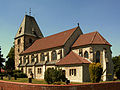
St. Martin in Hildesheim-Achtum

Interior view of St. Martin

Memorial stone "Uppener Pass" in Hildesheim-Uppen

Statue of Johannes von Nepomuk in Hildesheim-Uppen


Personalities
Sons and daughters of the district
- Franz Nause (1903–1943), social democratic resistance fighter
Web links
Individual evidence
- ↑ a b Lower Saxony State Administration Office (ed.): Community directory for Lower Saxony . Municipalities and municipality-free areas. Self-published, Hanover January 1, 1973, p. 30 ( digital version [PDF; 21.3 MB ; accessed on November 8, 2019] District Hildesheim-Marienburg).
- ↑ a b Population of the city of Hildesheim as of December 31, 2019. In: hildesheim.de. Hildesheim Marketing GmbH, accessed on June 3, 2020 .
- ^ Federal Statistical Office (ed.): Historical municipality directory for the Federal Republic of Germany. Name, border and key number changes in municipalities, counties and administrative districts from May 27, 1970 to December 31, 1982 . W. Kohlhammer, Stuttgart / Mainz 1983, ISBN 3-17-003263-1 , p. 204 .
- ↑ Ulrich Schubert: Community directory Germany 1900 - district of Marienburg. Information from December 1, 1910. In: gemeindeververzeichnis.de. February 3, 2019, accessed November 8, 2019 .
- ^ A b c Michael Rademacher: German administrative history from the unification of the empire in 1871 to the reunification in 1990. Marienburg district ( see under: No. 1 ). (Online material for the dissertation, Osnabrück 2006).
- ^ Federal Statistical Office (ed.): Official municipality directory for the Federal Republic of Germany . Final results according to the September 13, 1950 census. Volume 33 . W. Kohlhammer Verlag, Stuttgart / Cologne August 1952, p. 35 , col. 1 ( digital version [PDF; 26.4 MB ; accessed on November 8, 2019] District Hildesheim-Marienburg, p. 44).
- ^ Population of the city of Hildesheim as of December 31, 2016. In: hildesheim.de. December 31, 2016, accessed November 8, 2019 .
- ↑ a b Local council of Achtum-Uppen. In: Sitzungsdienst-hildesheim.de. Retrieved November 8, 2019 .
- ^ August Söding: Register of coat of arms of the Hildesheim-Marienburg district . Ed .: Heimatbund des Landkreis Hildesheim-Marienburg e. V. (= local history series of publications . No. 7 ). Schwitalla Verlag, Himmelsthür 1966, p. 34-35 .
City center and new town | Marienburger Höhe with Galgenberg | Moritzberg | North town with tax forest | East town
Achtum-Uppen | Bavenstedt | Drispenstedt | On one | Himmelsthür | Itzum - Marienburg | Neuhof / Hildesheim Forest / Marienrode | Ochtersum | Sorsum