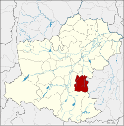
Amphoe Nong Bun Mak
|
Nong Bun Mak หนอง บุญ มาก |
|
|---|---|
| Province: | Nakhon Ratchasima |
| Surface: | 590.4 km² |
| Residents: | 60,174 (2013) |
| Population density : | 95.3 U / km² |
| ZIP : | 30410 |
| Geocode : | 3022 |
| map | |

|
|
Amphoe Nong Bun Mak ( Thai : อำเภอ หนอง บุญ มาก ) is a district ( amphoe - administrative district) in the province of Nakhon Ratchasima . The province of Nakhon Ratchasima is located in the northeast region of Thailand , the so-called Isan .
geography
Nong Bun Mak borders the following counties (from the east clockwise) to Amphoe Nong Ki of Buriram Province , and to the Amphoe Khon Buri , Chok Chai and Chakkarat in the province of Nakhon Ratchasima.
history
On July 1, 1983, a "branch circle " ( King Amphoe ) called Nong Bunnak was established by separating the three Tambon Nong Bunnak, Saraphi and Thai Charoen from the Chok Chai district . On May 5, 1989, it was officially promoted to Amphoe. In 2003, Non Bunnak County was renamed Nong Bun Mak.
administration
Provincial Administration
Nong Bun Mak County is divided into nine tambon ("subdistricts" or "parishes"), which are further divided into 103 muban ("villages").
| No. | Surname | Thai | Muban | Pop. |
|---|---|---|---|---|
| 1. | Nong Bunnak | หนอง บุ น นา ก | 17th | 10,387 |
| 2. | Saraphi | สารภี | 15th | 9,490 |
| 3. | Thai Charoen | ไทย เจริญ | 8th | 3,076 |
| 4th | Nong Hua Raet | หนอง หัว แร ต | 14th | 8,912 |
| 5. | Laem Thong | แหลมทอง | 10 | 6,034 |
| 6th | Nong Takai | หนอง ตะ ไก้ | 12 | 8,668 |
| 7th | Lung Khwao | ลุง เข ว้า | 9 | 4,614 |
| 8th. | Nong Mai Phai | หนอง ไม้ไผ่ | 9 | 3,951 |
| 9. | Ban Mai | บ้าน ใหม่ | 9 | 5,042 |
Local administration
There are two municipalities with "small town" status ( Thesaban Tambon ) in the district:
- Nong Hua Raet (Thai: เทศบาล ตำบล หนอง หัว แร ต ), consisting of the entire tambon Nong Hua Raet.
- Laem Thong (Thai: เทศบาล ตำบล แหลมทอง ), consisting of the entire tambon Laem Thong.
There are also seven " Tambon Administrative Organizations " ( องค์การ บริหาร ส่วน ตำบล - Tambon Administrative Organizations, TAO):
- Nong Bunnak (Thai: องค์การ บริหารส่วน ตำบล หนอง บุ น นา ก )
- Saraphi (Thai: องค์การ บริหาร ส่วน ตำบล สารภี )
- Thai Charoen (Thai: องค์การ บริหาร ส่วน ตำบล ไทย เจริญ )
- Nong Takai (Thai: องค์การ บริหาร ส่วน ตำบล หนอง ตะ ไก้ )
- Lung Khwao (Thai: องค์การ บริหาร ส่วน ตำบล ลุง เข ว้า )
- Nong Mai Phai (Thai: องค์การ บริหาร ส่วน ตำบล หนอง ไม้ไผ่ )
- Ban Mai (Thai: องค์การ บริหาร ส่วน ตำบล บ้าน ใหม่ )
Individual evidence
- ↑ ประกาศ กระทรวง มหาดไทย เรื่อง แบ่ง ท้องที่ อำเภอ โชคชัย จังหวัด นครราชสีมา ตั้ง เป็น กิ่ง อำเภอ หนอง บุ น นา ก . In: Royal Gazette . 100, No. 109 ง , July 5, 1983, p. 2133.
- ↑ พระราชกฤษฎีกา ตั้ง อำเภอ แวงใหญ่ อำเภอ หนอง บุ น นา ก อำเภอ โพนทราย อำเภอ ท่า หลวง และ อำเภอ ศรี รัตนะ พ.ศ. ๒๕๓๒ . In: Royal Gazette . 106, No. 83 ก ฉบับ พิเศษ (special), May 25, 1989, pp. 249-251.
- ↑ พระราชกฤษฎีกา เปลี่ยน ชื่อ อำเภอ หนอง บุ น นา ก จังหวัด นครราชสีมา พ.ศ. ๒๕๔๖ . In: Royal Gazette . 120, No. 36 ก , May 1, 2003, pp. 7–8.
- ↑ 2013 population statistics ( Thai ) Department of Provincial Administration. Retrieved July 31, 2014.
Web links
Coordinates: 14 ° 44 ' N , 102 ° 22' E
