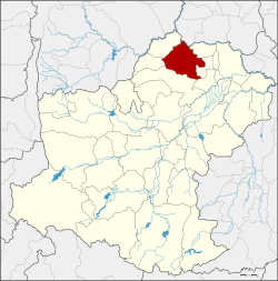
Bua Yai district
|
Bua Yai บัวใหญ่ |
|
|---|---|
| Province: | Nakhon Ratchasima |
| Surface: | 271.6 km² |
| Residents: | 83,233 (2013) |
| Population density : | 319.5 U / km² |
| ZIP : | 30120 |
| Geocode : | 3012 |
| map | |

|
|
Amphoe Bua Yai ( Thai : อำเภอ บัวใหญ่ ) is a district ( Amphoe - administrative district) in the north of the province of Nakhon Ratchasima . The province of Nakhon Ratchasima is located in the northeast region of Thailand , the so-called Isan .
geography
Neighboring districts (clockwise from north): Amphoe Waeng Noi of Khon Kaen Province and Amphoe Bua Lai , Sida , Non Daeng , Khong , Ban Lueam and Kaeng Sanam Nang of Nakhon Ratchasima Province.
history
The history of Bua Yai County can be traced back to when it was called Dan Nok ( ด่าน นอก ) as the border district . The city center was Ban Nong Lang Yai. In 1868 it became Dan Nok District and the city center was moved to Ban Nong Lang Noi. In 1905 the administration was again transferred to Ban Bua Yai, and the entire county was also renamed Ban Bua Yai. At that time, the administration building was 3 km from Bua Yai Railway Station. Due to the railway, the village of Ban Fat Fueai developed so well that the new administration building was built here in 1951.
traffic
The “Northeast Line” of the Thai State Railroad runs through Amphoe Bua Yai from Bangkok ( Hua Lamphong Station ) to Nong Khai . Here in the district, the two branch lines also unite, which lead from Kaeng Khoi Junction once via Lop Buri and once via Nakhon Ratchasima to Bua Yai Junction ( ชุม ทาง บัวใหญ่ ).
administration
Provincial Administration
Bua Yai County is divided into ten tambon ("sub-districts" or "parishes"), which are further subdivided into 121 muban ("villages").
| No. | Surname | Thai | Muban | Pop. |
|---|---|---|---|---|
| 1. | Bua Yai | บัวใหญ่ | 2 | 23,178 |
| 3. | Huai Yang | ห้วย ยาง | 12 | 7,551 |
| 4th | Sema Yai | เสมา ใหญ่ | 11 | 4,980 |
| 6th | Don Tanin | ดอน ตะ ห นิ น | 13 | 4,283 |
| 7th | Nong Bua Sa-at | หนองบัว สะอาด | 10 | 6,838 |
| 8th. | Non Thonglang | โนน ทองหลาง | 15th | 8,610 |
| 14th | Kut Chok | กุด จอก | 14th | 5,707 |
| 15th | Dan Chang | ด่านช้าง | 11 | 7,566 |
| 20th | Khun Thong | ขุนทอง | - | 7,899 |
| 24. | Nong Chaeng Yai | หนอง แจ้ง ใหญ่ | 10 | 6,621 |
Note: The missing geocode numbers are the tambon that now form Amphoe Kaeng Sanam Nang , Sida and Bua Lai .
Some of the Muban's data are not yet available.
Local administration
There is one commune with "city" status ( Thesaban Mueang ) in the district:
- Bua Yai (Thai: เทศบาล เมือง บัวใหญ่ ) consists of parts of the tambon Bua Yai.
There is one municipality with "small town" status ( Thesaban Tambon ) in the district:
- Nong Bua Sa-at (Thai: เทศบาล ตำบล หนองบัว สะอาด ) consists of the entire tambon Nong Bua Sa-at.
There are also nine " Tambon Administrative Organizations " ( องค์การ บริหาร ส่วน ตำบล - Tambon Administrative Organizations, TAO):
- Bua Yai (Thai: องค์การ บริหาร ส่วน ตำบล บัวใหญ่ )
- Huai Yang (Thai: องค์การ บริหาร ส่วน ตำบล ห้วย ยาง )
- Sema Yai (Thai: องค์การ บริหาร ส่วน ตำบล เสมา ใหญ่ )
- Don Tanin (Thai: องค์การ บริหาร ส่วน ตำบล ดอน ตะ ห นิ น )
- Non Thonglang (Thai: องค์การ บริหาร ส่วน ตำบล โนน ทองหลาง )
- Kut Chok (Thai: องค์การ บริหาร ส่วน ตำบล กุด จอก )
- Dan Chang (Thai: องค์การ บริหาร ส่วน ตำบล ด่านช้าง )
- Khun Thong (Thai: องค์การ บริหาร ส่วน ตำบล ขุนทอง )
- Nong Chaeng Yai (Thai: องค์การ บริหาร ส่วน ตำบล หนอง แจ้ง ใหญ่ )
Individual evidence
- ↑ 2013 population statistics ( Thai ) Department of Provincial Administration. Retrieved July 31, 2014.
Web links
Coordinates: 15 ° 35 ' N , 102 ° 25' E

