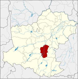
Chok Chai district
|
Chok Chai โชคชัย |
|
|---|---|
| Province: | Nakhon Ratchasima |
| Surface: | 503.9 km² |
| Residents: | 80,646 (2013) |
| Population density : | 146.2 U / km² |
| ZIP : | 30190 |
| Geocode : | 3007 |
| map | |

|
|
Amphoe Chok Chai (in Thai : อำเภอ โชคชัย ) is a district ( Amphoe - administrative district) in the south of the province of Nakhon Ratchasima . The province of Nakhon Ratchasima is located in the northeast region of Thailand , the so-called Isan .
geography
The neighboring districts are (clockwise from the north) Mueang Nakhon Ratchasima , Chaloem Phra Kiat , Nong Bun Mak , Khon Buri and Pak Thong Chai .
history
The former name of this amphoe was Kra Thok ( กระ โท ก ). Because of the better sound of the name, among other things, it was renamed Chok Chai, which in German means victory , in 1945 . The name was chosen to commemorate the victory of King Taksin the Great over the warlords of Phimai after the fall of Ayutthaya .
Attractions
- Prang Pha-Kho (Thai: ปรางค์ พะ โค ) - ruins of a Khmer temple from the 11th century
administration
Provincial Administration
The district of Chok Chai is divided into 10 tambon ("subdistricts" or "communities"), which are further subdivided into 132 muban ("villages").
| No. | Surname | Thai | Muban | Pop. |
|---|---|---|---|---|
| 1. | Krathok | กระ โท ก | 13 | 7,638 |
| 2. | Phlapphla | พลับพลา | 18th | 8,286 |
| 3. | Tha Ang | ท่า อ่าง | 10 | 8,030 |
| 4th | Thung Arun | ทุ่ง อรุณ | 17th | 8,025 |
| 5. | Tha Lat Khao | ท่า ลาด ขาว | 11 | 4,057 |
| 6th | Tha Chalung | ท่า จะ ห ลุง | 10 | 5,021 |
| 7th | Tha Yiam | ท่า เยี่ยม | 16 | 10,673 |
| 8th. | Chok Chai | โชคชัย | 15th | 13,647 |
| 9. | Lalom Mai Phatthana | ละ ลม ใหม่ พัฒนา | 12 | 6,504 |
| 10. | Dan Kwian | ด่าน เกวียน | 10 | 8,765 |
Local administration
There are three municipalities with "small town" status ( Thesaban Tambon ) in the district:
- Chok Chai (Thai: เทศบาล ตำบล โชคชัย ) consists of parts of the Tambon Chok Chai and Kra Thok.
- Dan Kwian (Thai: เทศบาล ตำบล ด่าน เกวียน ) consists of parts of the tambon Dan Kwian and Tha Ang.
- Tha Yiam (Thai: เทศบาล ตำบล ท่า เยี่ยม ) consists of the entire Tambon Tha Yiam.
There are also nine " Tambon Administrative Organizations " ( องค์การ บริหาร ส่วน ตำบล - Tambon Administrative Organizations, TAO):
- Krathok (Thai: องค์การ บริหารส่วน ตำบล กระ โท ก ) consisting of parts of the Tambon Krathok.
- Phlapphla (Thai: องค์การ บริหาร ส่วน ตำบล พลับพลา )
- Tha Ang (Thai: องค์การ บริหาร ส่วน ตำบล ท่า อ่าง )
- Thung Arun (Thai: องค์การ บริหาร ส่วน ตำบล ทุ่ง อรุณ )
- Tha Lat Khao (Thai: องค์การ บริหาร ส่วน ตำบล ท่า ลาด ขาว )
- Tha Chalung (Thai: องค์การ บริหาร ส่วน ตำบล ท่า จะ ห ลุง )
- Chok Chai (Thai: องค์การ บริหาร ส่วน ตำบล โชคชัย ) consisting of parts of the Tambon Chok Chai.
- Lalom Mai Phatthana (Thai: องค์การ บริหาร ส่วน ตำบล ละ ลม ใหม่ พัฒนา )
- Dan Kwian (Thai: องค์การ บริหาร ส่วน ตำบล ด่าน เกวียน ) consisting of parts of the Tambon Dan Kwian.
Individual evidence
- ↑ พระราชกฤษฎีกา เปลี่ยน ชื่อ อำเภอ กระ โท ก พุทธศักราช ๒๔๘๖ . In: Royal Gazette . 60, No. 69 ก , December 28, 1943, pp. 1800–1801.
- ↑ 2013 population statistics ( Thai ) Department of Provincial Administration. Retrieved July 31, 2014.
Web links
Coordinates: 14 ° 44 ' N , 102 ° 10' E

