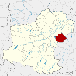
Huai Thalaeng district
|
Huai Thalaeng ห้วยแถลง |
|
|---|---|
| Province: | Nakhon Ratchasima |
| Surface: | 495.2 km² |
| Residents: | 75,248 (2013) |
| Population density : | 158.7 U / km² |
| ZIP : | 30240 |
| Geocode : | 3016 |
| map | |

|
|
Amphoe Huai Thalaeng ( Thai : อำเภอ ห้วยแถลง ) is a district ( Amphoe - administrative district) in the east of the province of Nakhon Ratchasima . The province of Nakhon Ratchasima is located in the northeast region of Thailand , the so-called Isan .
geography
Huai Thalaeng District borders the following counties (from west clockwise) to the Amphoe Chakkarat , Phimai and Chum Phuang in the province of Nakhon Ratchasima, and to the Amphoe Lam Plai Mat and Nong Hong of Buriram Province .
history
The village of Huai Thalaeng was originally administered by the Tambon Ngio ( ตำบล งิ้ว ) of Amphoe Phimai . In 1961 it was promoted to Tambon Huai Thalaeng and a little later to "Branch Circle" ( King Amphoe ) . In 1963 the small district was elevated to an amphoe.
administration
Provincial Administration
Huai Thalaeng County is divided into ten tambon ("subdistricts" or "parishes"), which are further subdivided into 120 muban ("villages").
| No. | Surname | Thai | Muban | Pop. |
|---|---|---|---|---|
| 1. | Huai Thalaeng | ห้วยแถลง | 13 | 10,380 |
| 2. | Thap Sawai | ทับ สวาย | 8th | 4,320 |
| 3. | Mueang Phlapphla | เมือง พลับพลา | 13 | 8,737 |
| 4th | Lung Takhian | ห ลุ่ ง ตะเคียน | 15th | 9.206 |
| 5. | Hin Dat | หิน ดาด | 15th | 10,328 |
| 6th | Ngio | งิ้ว | 14th | 8,654 |
| 7th | Kong red | ก ง รถ | 9 | 4,433 |
| 8th. | Lung Pradu | ห ลุ่ ง ประดู่ | 15th | 10,379 |
| 9. | Tako | ตะโก | 10 | 4,525 |
| 10. | Huai Khaen | ห้วย แคน | 8th | 4,286 |
Local administration
There are three municipalities with "small town" status ( Thesaban Tambon ) in the district:
- Kong red (Thai: เทศบาล ตำบล ก ง รถ ), consisting of the entire tambon Kong red.
- Huai Thalaeng (Thai: เทศบาล ตำบล ห้วยแถลง ), consisting of parts of the tambon Huai Thalaeng and Thap Sawai.
- Hin Dat (Thai: เทศบาล ตำบล หิน ดาด ), consisting of parts of the tambon Hin Dat.
There are also six " Tambon Administrative Organizations " ( องค์การ บริหาร ส่วน ตำบล - Tambon Administrative Organizations, TAO):
- Huai Thalaeng (Thai: องค์การ บริหาร ส่วน ตำบล ห้วยแถลง )
- Thap Sawai (Thai: องค์การ บริหาร ส่วน ตำบล ทับ สวาย )
- Mueang Phlapphla (Thai: องค์การ บริหาร ส่วน ตำบล เมือง พลับพลา )
- Lung Takhian (Thai: องค์การ บริหาร ส่วน ตำบล ห ลุ่ ง ตะเคียน )
- Hin Dat (Thai: องค์การ บริหาร ส่วน ตำบล หิน ดาด )
- Ngio (Thai: องค์การ บริหาร ส่วน ตำบล งิ้ว )
- Lung Pradu (Thai: องค์การ บริหาร ส่วน ตำบล ห ลุ่ ง ประดู่ )
- Tako (Thai: องค์การ บริหาร ส่วน ตำบล ตะโก )
- Huai Khaen (Thai: องค์การ บริหาร ส่วน ตำบล ห้วย แคน )
Individual evidence
- ↑ 2013 population statistics ( Thai ) Department of Provincial Administration. Retrieved July 31, 2014.
Web links
Coordinates: 15 ° 0 ' N , 102 ° 38' E
