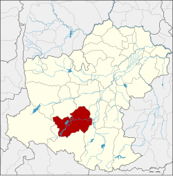
Pak Thong Chai district
|
Pak Thong Chai ปักธงชัย |
|
|---|---|
| Province: | Nakhon Ratchasima |
| Surface: | 1,374.3 km² |
| Residents: | 117,271 (2013) |
| Population density : | 83.9 U / km² |
| ZIP : | 30150 |
| Geocode : | 3014 |
| map | |

|
|
Amphoe Pak Thong Chai ( Thai : อำเภอ ปักธงชัย ) is a district ( Amphoe - administrative district) in the south of the province of Nakhon Ratchasima . The province of Nakhon Ratchasima is located in the northeast region of Thailand , the so-called Isan .
geography
Amphoe Pak Thong Chai borders the following counties (from the north clockwise): Amphoe Sung Noen , Mueang Nakhon Ratchasima , Chok Chai , Khon Buri and Wang Nam Khiao . All Amphoe are in Nakhon Ratchasima Province.
history
The area had been an important city since the Khmer era , it was subordinate to Mueang Phimai . During the reign of King Ramathibodi I of the Ayutthaya Kingdom , it was called Mueang Pak. When King Narai founded the Mueang Nakhon Ratchasima as the north-eastern border town of the empire, Mueang Pak was directly in the outer border area, then called Dan Chapo ( ด่าน จะ โปะ ). King Taksin changed the name to Pak Thong Chai and settled prisoners of war from Laos here. He promoted Phia Upparacha of the Kingdom of Vientiane to Phraya Wongsa Akkharat ( พระยา วง ษา อรรค ราช ), the governor of Pak Thong Chai.
King Chulalongkorn (Rama V) upgraded the city's status to amphoe in 1908 as part of the thesaphiban administrative reform .
administration
Provincial Administration
Pak Thong Chai County is divided into 16 tambon ("subdistricts" or "parishes"), which are further subdivided into 215 muban ("villages").
| No. | Surname | Thai | Muban | Pop. |
|---|---|---|---|---|
| 1. | Mueang Pak | เมือง ปัก | 18th | 18,491 |
| 2. | Takhu | ตะ คุ | 21st | 12,270 |
| 3. | Khok Thai | โคก ไทย | 11 | 4,669 |
| 4th | Samrong | สำโรง | 10 | 3,517 |
| 5. | Takhop | ตะขบ | 22nd | 14,529 |
| 6th | Nok Ok | นก ออก | 10 | 5,960 |
| 7th | Don | ดอน | 12 | 4,288 |
| 9. | Tum | ตูม | 16 | 5,529 |
| 10. | Ngio | งิ้ว | 15th | 6,656 |
| 11. | Sakae Council | สะแก ราช | 15th | 8,646 |
| 12. | Lam Nang Kaeo | ลำ นาง แก้ว | 9 | 5,195 |
| 16. | Phu Luang | ภู หลวง | 10 | 5,661 |
| 17th | Thong Chai Nuea | ธงชัย เหนือ | 16 | 9,095 |
| 18th | Suk Kasem | สุข เกษม | 11 | 4,827 |
| 19th | Kasem Sap | เกษม ทรัพย์ | 9 | 3,665 |
| 20th | Bo Pla Thong | บ่อ ปลาทอง | 10 | 4,273 |
Local administration
There is one commune with "city" status ( Thesaban Mueang ) in the district:
- Mueang Pak (Thai: เทศบาล เมือง เมือง ปัก ), consisting of parts of the Tambon Mueang Pak and Thong Chai Nuea.
There are five municipalities with "small town" status ( Thesaban Tambon ) in the district:
- Pak Thong Chai (Thai: เทศบาล ตำบล ปักธงชัย ), consisting of other parts of the Tambon Mueang Pak.
- Nok Ok (Thai: เทศบาล ตำบล นก ออก ), consisting of the entire tambon Nok Ok.
- Bo Pla Thong (Thai: เทศบาล ตำบล บ่อ ปลาทอง ), consisting of further parts of the Tambon Bo Pla Thong.
- Takhop (Thai: เทศบาล ตำบล ตะขบ ), consisting of parts of the Tambon Takhop, Lam Nang Kaeo and Bo Pla Thong.
- Lam Nang Kaeo (Thai: เทศบาล ตำบล ลำ นาง แก้ว ), consisting of further parts of the Tambon Lam Nang Kaeo.
There are also twelve " Tambon Administrative Organizations " ( องค์การ บริหาร ส่วน ตำบล - Tambon Administrative Organizations, TAO):
- Takhu (Thai: องค์การ บริหารส่วน ตำบล ตะ คุ )
- Khok Thai (Thai: องค์การ บริหาร ส่วน ตำบล โคก ไทย )
- Samrong (Thai: องค์การ บริหาร ส่วน ตำบล สำโรง )
- Takhop (Thai: องค์การ บริหาร ส่วน ตำบล ตะขบ )
- Don (Thai: องค์การ บริหาร ส่วน ตำบล ดอน )
- Tum (Thai: องค์การ บริหาร ส่วน ตำบล ตูม )
- Ngio (Thai: องค์การ บริหาร ส่วน ตำบล งิ้ว )
- Sakae Rat (Thai: องค์การ บริหาร ส่วน ตำบล สะแก ราช )
- Phu Luang (Thai: องค์การ บริหาร ส่วน ตำบล ภู หลวง )
- Thong Chai Nuea (Thai: องค์การ บริหาร ส่วน ตำบล ธงชัย เหนือ )
- Suk Kasem (Thai: องค์การ บริหาร ส่วน ตำบล สุข เกษม )
- Kasem Sap (Thai: องค์การ บริหาร ส่วน ตำบล เกษม ทรัพย์ )
Individual evidence
- ↑ 2013 population statistics ( Thai ) Department of Provincial Administration. Retrieved July 31, 2014.
Web links
Coordinates: 14 ° 43 ' N , 102 ° 1' E
