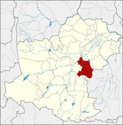
Chakkarat district
|
Chakkarat จักราช |
|
|---|---|
| Province: | Nakhon Ratchasima |
| Surface: | 501.7 km² |
| Residents: | 70,753 (2013) |
| Population density : | 132.8 U / km² |
| ZIP : | 30230 |
| Geocode : | 3006 |
| map | |

|
|
Amphoe Chakkarat ( Thai : อำเภอ จักราช ) is a district ( Amphoe - administrative district) in the east of the province of Nakhon Ratchasima . The province of Nakhon Ratchasima is located in the northeast region of Thailand , the so-called Isan .
geography
Amphoe Chakkarat borders the following counties (clockwise from the south): Amphoe Nong Bun Mak , Chok Chai , Chaloem Phra Kiat , Non Sung , Phimai and Huai Thalaeng in Nakhon Ratchasima Province, as well as Amphoe Nong Hong and Nong Ki in Buriram Province .
The main river in the county is the Mae Nam Mun (Mun River) .
history
The village of Tha Chang was upgraded to a "branch circle" ( King Amphoe ) of the Amphoe Mueang Nakhon Ratchasima in 1927 . In 1953 it was officially upgraded to an Amphoe, at the same time the name was changed from Tha Chang to Chakkarat. The administration was moved to Ban Talat Chakkarat in 1964.
administration
Provincial Administration
The district of Chakkarat is divided into eight tambon ("subdistricts" or "communities"), which are further subdivided into 109 muban ("villages").
| No. | Surname | Thai | Muban | Pop. |
|---|---|---|---|---|
| 1. | Chakkarat | จักราช | 14th | 12,253 |
| 3. | Thonglang | ทองหลาง | 10 | 7,887 |
| 4th | Si Suk | สีสุก | 15th | 8,720 |
| 5. | Nong Kham | หนอง ขาม | 2 | 9,385 |
| 7th | Nong Phluang | หนอง พลวง | 16 | 7,577 |
| 10. | Si Lako | ศรี ละ กอ | 2 | 9,859 |
| 11. | Khlong Mueang | คลอง เมือง | 11 | 8,427 |
| 13. | Hin Khon | หิน โคน | 11 | 6,645 |
Notes: The missing numbers (geocodes) refer to the tambon , which today belong to the Chaloem Phra Kiat .
Some of the Muban's data are not yet available.
Local administration
There is one municipality with "small town" status ( Thesaban Tambon ) in the district:
- Chakkarat (Thai: เทศบาล ตำบล จักราช ), consisting of parts of the Tambon Chakkarat.
There are also eight " Tambon Administrative Organizations " ( องค์การ บริหาร ส่วน ตำบล - Tambon Administrative Organizations, TAO):
- Chakkarat (Thai: องค์การ บริหาร ส่วน ตำบล จักราช )
- Thonglang (Thai: องค์การ บริหาร ส่วน ตำบล ทองหลาง )
- Si Suk (Thai: องค์การ บริหาร ส่วน ตำบล สีสุก )
- Nong Kham (Thai: องค์การ บริหาร ส่วน ตำบล หนอง ขาม )
- Nong Phluang (Thai: องค์การ บริหาร ส่วน ตำบล หนอง พลวง )
- Si Lako (Thai: องค์การ บริหาร ส่วน ตำบล ศรี ละ กอ )
- Khlong Mueang (Thai: องค์การ บริหาร ส่วน ตำบล คลอง เมือง )
- Hin Khon (Thai: องค์การ บริหาร ส่วน ตำบล หิน โคน )
Individual evidence
- ↑ 2013 population statistics ( Thai ) Department of Provincial Administration. Retrieved July 31, 2014.
Web links
Coordinates: 15 ° 1 ′ N , 102 ° 25 ′ E
