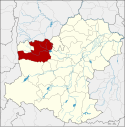
Amphoe Dan Khun Thot
|
Dan Khun Thot ด่านขุนทด |
|
|---|---|
| Province: | Nakhon Ratchasima |
| Surface: | 1428.1 km² |
| Residents: | 127,938 (2013) |
| Population density : | 88.4 U / km² |
| ZIP : | 30210, 36220 |
| Geocode : | 3008 |
| map | |

|
|
Amphoe Dan Khun Thot ( Thai : อำเภอ ด่านขุนทด ) is a district ( Amphoe - administrative district) in the west of the province of Nakhon Ratchasima . The province of Nakhon Ratchasima is located in the northeast region of Thailand , the so-called Isan .
geography
Dan Khun Thot District borders the following counties (from north clockwise) to the Amphoe Bamnet Narong and Chatturat of Chaiyaphum province , the Amphoe Phra Thong Kham , Non Thai , Kham Thale So , Sung Noen and Sikhio in the province of Nakhon Ratchasima , at Amphoe Lam Sonthi in the province of Lop Buri , and at Amphoe Thepharak in Nakhon Ratchasima.
history
The place Dan Khun Thot was founded before the reign of King Taksin . In 1908 it was promoted to amphoe. At the same time, the center of Wat Pho Chumphon was moved to the west side of the Ban Han School. Therefore, the district was renamed Amphoe Ban Han. The name was later changed to Phan Chana, and again to Dan Khun Thot shortly afterwards in 1914.
administration
Provincial Administration
Dan Khun Thot County is divided into 16 tambon ("subdistricts" or "communities"), which are further subdivided into 225 muban ("villages").
| No. | Surname | Thai | Muban | Pop. |
|---|---|---|---|---|
| 1. | Kut Phiman | กุด พิมาน | 15th | 9,733 |
| 2. | Dan Khun Thot | ด่านขุนทด | 17th | 16,141 |
| 3. | Ok then | ด่าน นอก | 7th | 4,204 |
| 4th | Dan Nai | ด่าน ใน | 8th | 4,658 |
| 5. | Takhian | ตะเคียน | 6th | 11,408 |
| 6th | Ban Kao | บ้าน เก่า | 13 | 7,439 |
| 7th | Ban Praeng | บ้าน แปรง | - | 6,741 |
| 8th. | Phan Chana | พัน ชนะ | 11 | 6,349 |
| 9. | Sa Chorakhe | สระ จร เข้ | 13 | 6.134 |
| 10. | Nong Krat | หนอง กราด | 11 | 9,722 |
| 11. | Nong Bua Takiat | หนองบัว ตะ เกียด | 15th | 8,792 |
| 12. | Nong Bua Lakhon | หนองบัว ละคร | 9 | 3,552 |
| 13. | Hin Dat | หิน ดาด | 15th | 13,458 |
| 15th | Huai Bong | ห้วย บ ง | 25th | 10.120 |
| 17th | Non Mueang Phatthana | โนน เมือง พัฒนา | 11 | 4,433 |
| 18th | Nong Sai | หนอง ไทร | 11 | 5,054 |
Note: Some of the Muban's data are not yet available.
Local administration
There are three municipalities with "small town" status ( Thesaban Tambon ) in the district:
- Dan Khun Thot (Thai: เทศบาล ตำบล ด่านขุนทด ), consisting of parts of the tambon Dan Khun Thot,
- Nong Krat (Thai: เทศบาล ตำบล หนอง กราด ), consisting of parts of the Tambon Nong Krat,
- Nong Bua Takiat (Thai: เทศบาล ตำบล หนองบัว ตะ เกียด ), consisting of the entire tambon Nong Bua Takiat.
There are also 15 " Tambon Administrative Organizations " ( องค์การ บริหาร ส่วน ตำบล - Tambon Administrative Organizations, TAO):
- Kut Phiman (Thai: องค์การ บริหาร ส่วน ตำบล กุด พิมาน )
- Dan Khun Thot (Thai: องค์การ บริหาร ส่วน ตำบล ด่านขุนทด )
- Dan Nok (Thai: องค์การ บริหาร ส่วน ตำบล ด่าน นอก )
- Dan Nai (Thai: องค์การ บริหาร ส่วน ตำบล ด่าน ใน )
- Takhian (Thai: องค์การ บริหาร ส่วน ตำบล ตะเคียน )
- Ban Kao (Thai: องค์การ บริหาร ส่วน ตำบล บ้าน เก่า )
- Ban Praeng (Thai: องค์การ บริหาร ส่วน ตำบล บ้าน แปรง )
- Phan Chana (Thai: องค์การ บริหาร ส่วน ตำบล พัน ชนะ )
- Sa Chorakhe (Thai: องค์การ บริหาร ส่วน ตำบล สระ จร เข้ )
- Nong Krat (Thai: องค์การ บริหาร ส่วน ตำบล หนอง กราด )
- Nong Bua Lakhon (Thai: องค์การ บริหาร ส่วน ตำบล หนองบัว ละคร )
- Hin Dat (Thai: องค์การ บริหาร ส่วน ตำบล หิน ดาด )
- Huai Bong (Thai: องค์การ บริหาร ส่วน ตำบล ห้วย บ ง )
- Non Mueang Phatthana (Thai: องค์การ บริหาร ส่วน ตำบล โนน เมือง พัฒนา )
- Nong Sai (Thai: องค์การ บริหาร ส่วน ตำบล หนอง ไทร )
Individual evidence
- ↑ ประกาศ กระทรวง มหาดไทย ประกาศ เปลี่ยน ชื่อ อำเภอ. อำเภอ พะ ชะ นะ เป็น อำเภอ ด่านขุนทด อำเภอ ท่าบ่อ เป็น อำเภอ เมือง พาน พร้าว และ อำเภอ สนาม จันทร์ เป็น อำเภอ เขา เขา โดย โดย มี การ กล่าว ถึง วิธี ขนาน นาม อำเภอ มา แต่ โบราณ ให้ ศึกษา ด้วย . In: Royal Gazette . 31, No. 0 ง , July 26, 1914, pp. 928-931.
- ↑ 2013 population statistics ( Thai ) Department of Provincial Administration. Retrieved July 31, 2014.
Web links
- Amphoe Dan Khun Thot from amphoe.com (in Thai)
Coordinates: 15 ° 13 ' N , 101 ° 46' E
