Beijing-Harbin Highway
| G1 highway in China | |

|
|
| map | |
| Basic data | |
| Operator: | |
| Overall length: | 1240 km |
| Beijing-Harbin Highway | |
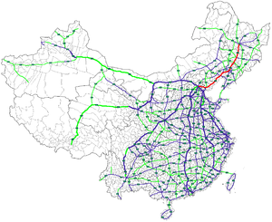
The Beijing-Harbin or Jingha Highway ( Chinese 京哈高速 , Pinyin Jīng-Hā gāosù gōnglù , English Jingha Expressway ), Chinese abbreviation G1 , is a 1,240 km long highway in China , which connects the capital Beijing in the north with the Northeast Chinese metropolis Harbin connects. The motorway was opened between 1999 and 2001.
The highway runs from Beijing through the cities of Tangshan and Qinhuangdao in Hebei Province , Jinzhou and Shenyang in Liaoning Province, and Siping and Changchun in Jilin Province before reaching the capital of Heilongjiang Province , Harbin.
The name Jing-Ha 京 哈 is a combination of the last character of Peking (Beijing) and the character Ha, which stands for Harbin.


