Hangzhou – Ruili highway
| G56 highway in China | |

|
|
| map | |
| Basic data | |
| Operator: | |
| Overall length: | 2935 km |
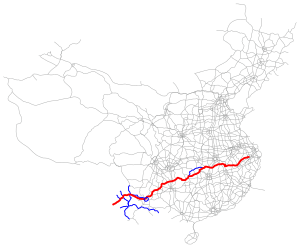
The Hangzhou – Ruili or Hangrui motorway ( Chinese 杭 瑞 高速公路 , Pinyin Hángruì gāosù gōnglù , English Hangrui Expressway ), Chinese abbreviation G56 , is a highway under construction in China , which will have a length of 2,935 km after completion becomes. It begins in the city of Hangzhou in the province of Zhejiang and heading west about Jingdezhen , Jiujiang , Xianning , Yueyang , Changde , Jishou , Zunyi , Bijie , Liupanshui , Qujing in the capital of Yunnan , Kunming . From there it continues via Chuxiong to Ruili on the border with Myanmar (Burma).
On the border between the provinces of Guizhou and Yunnan, the Beipanjiang Bridge , which was completed in 2016 and is currently the tallest bridge in the world, spans the valley of the Beipan Jiang River .

