Beijing-Hong Kong-Macau highway
| G4 highway in China | |

|
|
| map | |
| Basic data | |
| Operator: | |
| Overall length: | 2284 km |
| The Beijing-Hong Kong-Macau highway in Guangdong Province | |
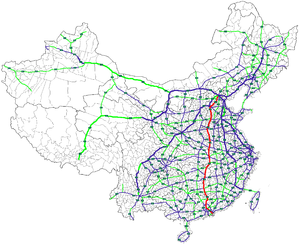
The Beijing-Hong Kong-Macau or Jinggang'ao highway ( Chinese 京 港澳 高速公路 , Pinyin Jīnggǎng'ào gāosù gōnglù , English Beijing-Hong Kong-Macau Expressway ), Chinese abbreviation G4 , is a 2,284 km long highway in China , which connects the capital Beijing in the north with the important southern Chinese economic region around Guangzhou (Canton), Hong Kong and Macau . The first section of the highway from Beijing to Shijiazhuang was built as early as 1986 and completed in 1993 as one of the first highways in China. The entire motorway was opened at the end of 2004.
The highway runs from Beijing through the cities of Baoding , Shijiazhuang and Handan in Hebei Province , Xinxiang , Zhengzhou , Luohe and Xinyang in Henan Province , Wuhan and Xianning in Hubei Province , Yueyang , Changsha , Zhuzhou , Hengyang and Chenzhou in the province Hunan and Shaoguan , Guangzhou , Shenzhen in Guangdong Province to Hong Kong . One branch of the highway, the G4W , branches off near Guangzhou and leads to Zhuhai near Macau.


