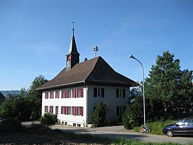
Bolken
| Bolken | |
|---|---|
| State : |
|
| Canton : |
|
| District : | Water authority |
| BFS no. : | 2514 |
| Postal code : | 4556 |
| Coordinates : | 617 072 / 226925 |
| Height : | 496 m above sea level M. |
| Height range : | 461–505 m above sea level M. |
| Area : | 2.12 km² |
| Residents: | 601 (December 31, 2018) |
| Population density : | 283 inhabitants per km² |
| Website: | www.bolken.ch |
|
school |
|
| Location of the municipality | |
Bolken ( Bouke in the local dialect ) is a municipality in the Wasseramt district in the canton of Solothurn in Switzerland .
geography
Bolken is 496 m above sea level. M. , 10 km east of the canton capital Solothurn (linear distance). The village is located on a hill west of the Önzberges , south of the depression in the Inkwilersees , in southern Solothurn Central Plateau .
The area of the 2.1 km² large municipal area comprises a section of the moraine landscape in the outer water authority, which was formed by the ice age Rhone glacier . The community soil extends from the Unterwald (up to 473 m above sea level ) to the southeast over the formerly boggy plain with the Inkwilersee up to the hill of Bolken, on the north of Aeschi at 503 m above sea level. M. the highest elevation of the community is reached. This hill with the Tägermoos and Turbenmoos corridors forms the western continuation of the Önzberg . The western part of Inkwilersee and half of the islet also belong to Bolken. In 1997, 10% of the municipal area was in settlements, 22% in forests and woodlands, 66% in agriculture and a little less than 2% was unproductive land.
The Längacher homestead ( 465 m above sea level ) west of the Inkwilersee on the edge of the lower forest belongs to Bolken . Bolken's neighboring communities are Aeschi (SO) , Etziken and Subingen in the canton of Solothurn and Inkwil and Niederönz in the canton of Bern .
population
With 601 inhabitants (as of December 31, 2018), Bolken is one of the smaller communities in the canton of Solothurn. 95.1% of the residents are German-speaking, 1.8% French-speaking and 1.2% speak Albanian (as of 2000). The population of Bolken was 230 inhabitants in 1850 and 265 in 1900. In the course of the 20th century the population always fluctuated between 250 and 280 inhabitants. Only since 1980 has a significant increase in population been recorded.
economy
Up until the second half of the 20th century, Bolken was a predominantly agricultural village. Even today, arable farming and fruit growing as well as cattle breeding have an important place in the income structure of the population. Other jobs are available in local small businesses and in the service sector, including in a company in the IT sector. In the last few decades the village has developed into a residential community. Many people in employment are therefore commuters who work mainly in the Solothurn and Herzogenbuchsee regions.
traffic
The community is located off the major thoroughfares, but is easily accessible from the Solothurn region . The nearest connection to the A1 motorway (Bern-Zurich) is around 7 km from the town center.
On June 1, 1857, the railway line from Herzogenbuchsee to Solothurn was put into operation; Inkwil station was only a little outside of the municipality. The line, which was closed for some time, is reactivated today, but is not used by regional trains. The municipality area is crossed by the Önzberg tunnel, which was opened in 2004 as part of Bahn 2000 . Bolken is connected to the public transport network through the BSU bus line , which serves the route from Solothurn to Herzogenbuchsee.
history
The municipality of Bolken was inhabited very early, which could be proven by traces of settlement from the Neolithic on the island in Lake Inkwil. The first documentary mention of the place took place only in 1429 under the name Bollikon . Later the names Bollikofen (1465), Bolliken (1469) and Bolckhen (1584) appeared. The place name goes back to the Old High German personal name Bollo . With the name ending -ken (actually a contraction of -igkofen ) it means something like the farms of the people of Bollo , whereby so-called repatriate farms are meant.
In the Middle Ages Bolken was under the rule of Aeschi. This came to Solothurn in 1466 and was assigned to the Vogtei Kriegstetten. After the collapse of the Ancien Régime (1798) Bolken belonged to the Biberist district during the Helvetic Republic and from 1803 to the Kriegstetten district, which was officially renamed the Wasseramt district in 1988. Bolken does not have its own church; since 1684 it belongs to the parish of Aeschi.
Attractions
coat of arms
- Ploughshare standing upright in red and white (seen from below), above two white five-pointed stars
Web links
- Official website of the municipality of Bolken
- Peter Kaiser: Bolken. In: Historical Lexicon of Switzerland .
- Aerial view of the village
Individual evidence
- ↑ Permanent and non-permanent resident population by year, canton, district, municipality, population type and gender (permanent resident population). In: bfs. admin.ch . Federal Statistical Office (FSO), August 31, 2019, accessed on December 22, 2019 .


