Basakşehir
| Basakşehir | |||
|
|||
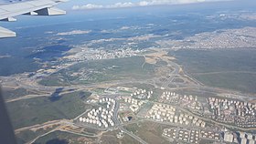
 Aerial view |
|||
| Basic data | |||
|---|---|---|---|
| Province (il) : | Istanbul | ||
| District ( ilçe ) : | Basakşehir | ||
| Coordinates : | 41 ° 0 ′ N , 28 ° 48 ′ E | ||
| Surface: | 104.48 km² | ||
| Residents : | 311,095 (2015) | ||
| Population density : | 2,978 inhabitants per km² | ||
| Telephone code : |
(+90) 212 (European part) (+90) 216 (Asian part) |
||
| Postal code : | 34 xxx | ||
| License plate : | 34 | ||
| Structure and administration (as of 2019) | |||
| Structure : | 10 malls | ||
| Mayor : | Yasin Kartoğlu ( AKP ) | ||
| Website: | |||
| Başakşehir County | |||
| Residents : | 342,422 (2015) | ||
| Kaymakam : | Kazım Tekin (since October 2014) | ||
| Website (Kaymakam): | |||
Başakşehir is a district on the European side of Istanbul and at the same time a district and municipality of the Istanbul Province .
geography
Geographical location
Başakşehir is located west of the geographical center of Istanbul. In the north it borders on the districts of Arnavutköy and Eyüp , in the east on Sultangazi and Esenler , in the south on Bağcılar , Küçükçekmece and Avcılar , and in the west on Esenyurt .
structure
Başakşehir is divided into 10 districts ( Mahalle in Turkish ):
| Mahalle | Residents |
|---|---|
| Altınşehir | 13,218 |
| Bahçeşehir - Part 1 | 15,189 |
| Bahçeşehir - Part 2 | 35,467 |
| Basak | 68,585 |
| Basakşehir | 46,068 |
| Güvercintepe | 49,334 |
| Kayabaşı | 57,410 |
| Şahintepe | 36,388 |
| Şamlar Köyü | 1,455 |
| Ziya Gökalp | 19,249 |
| Total (as of 2014) | 342,422 |
history
The historical name of the district was Azatlık in the Ottoman Empire . During the wars and battles, the Ottomans got the gunpowder for their projectiles from this part of the city. Since Azatlık was dominated by agriculture and there were many farms, the district was later called Resneli Çiftliği ("Resneli Farm"). The Ottoman military Ahmed Niyazi Bey , who played an important role in the Young Turkish Revolution , owned a farm in Başakşehir, which is still there today.
The plots around the farms developed into blocks of houses in the later years. The region continued to grow and more and more quarters were created. Istanbul's first settlements are in Başakşehir and were formed in the Yarımburgaz Cave in the Altınşehir district on the way to Kayabaşı. In the Paleolithic Age, the cave was the home of the indigenous people. In the cave there are also ruins of a Byzantine period church .
Başakşehir has developed rapidly since Turkey was founded. In 2007 the headquarters of Mercedes-Benz Türk was relocated here. In 2008, Başakşehir separated from Küçükçekmece and has been an independent district ever since. The former municipality of Bahçeşehir was incorporated into Başakşehir in 2009.
Sports
The largest stadium in Turkey, the Ataturk Olympic Stadium , is located in Başakşehir. The stadium has a capacity of 76,092 seats. The stadium was built on an area of 7,250 m² for over 100 million euros in 2002 on the occasion of the application for the 2008 Summer Olympics . The M3 metro line has been leading to the stadium since June 14, 2013. Previously, the stadium, which is located far outside the city, could only be reached by public transport using shuttle buses from Taksim Square .
The district is also home to the first division soccer team Istanbul Başakşehir FK , whose stadium is in the Başak district. The club became Turkish football champions for the first time in the 2019/20 season.
Web links
Individual evidence
- ^ Turkish Institute for Statistics, 2012 ( Memento from February 20, 2013 on WebCite ), accessed April 25, 2015
- ^ Turkish Institute for Statistics, 2014 ( Memento from February 10, 2015 on WebCite ), accessed April 25, 2015
- ↑ a b T.C. Başakşehir Kaymakamlığı: İlçemizin Tarihçesi - 2014 Mahalle Nüfüsları ( Memento from April 3, 2016 in the Internet Archive ) (accessed on April 3, 2016)


