
Barbentans
| Barbentans | ||
|---|---|---|
.svg)
|
|
|
| region | Provence-Alpes-Cote d'Azur | |
| Department | Bouches-du-Rhône | |
| Arrondissement | Arles | |
| Canton | Châteaurenard | |
| Community association | Terre de Provence | |
| Coordinates | 43 ° 54 ' N , 4 ° 45' E | |
| height | 12-167 m | |
| surface | 27.13 km 2 | |
| Residents | 4,143 (January 1, 2017) | |
| Population density | 153 inhabitants / km 2 | |
| Post Code | 13570 | |
| INSEE code | 13010 | |
| Website | www.barbentane.fr | |
 Barbentane Castle |
||

Barbentane is a municipality with 4143 inhabitants (as of January 1, 2017) in the south of France in the Bouches-du-Rhône (13) department of the Provence-Alpes-Côte d'Azur region .
geography
Barbentane is the northernmost municipality in the Bouches-du-Rhône department. It is located at the mouth of the Durance in the Rhone , about eight kilometers southwest of Avignon and on the northern edge of the Montagnette ridge . Barbentane is surrounded by the neighboring communities of Avignon in the north, Rognonas in the east, Graveson in the southeast, Tarascon in the south, Boulbon in the southwest, Aramon in the west and Les Angles in the northwest.
Population development
| year | 1962 | 1968 | 1975 | 1982 | 1990 | 1999 | 2006 | 2017 |
|---|---|---|---|---|---|---|---|---|
| Residents | 2616 | 2795 | 2864 | 3201 | 3273 | 3643 | 3660 | 4143 |
| Sources: Cassini and INSEE | ||||||||
Attractions
- The Barbentane castle The original castle was built in 1674 by the architect Mignard and Franque, the present condition was not completed until the 18th century. Joseph-Pierre Balthazar de Pujet, Count von Barbentane and ambassador to Louis XV. in Florence, has lavishly decorated the reception rooms with stucco and Carrara marble and with valuable furniture from the era of Louis XV. and Louis XVI. that can still be admired today.
- The castle is surrounded by Italian-style terraces. It has a park with 300 year old trees. The castle survived the French Revolution unscathed and is still inhabited today by the family of the Marquis von Barbentane. It is closed to the public.
- The Cours , the central square of the place with the town hall. In the 12th century it was named Place des Faubourgs , from the 15th century Jeu de ballon , in 1942 it was renamed Place du Maréchal Pétain and in 1944 Cours Jean-Baptiste Rey .
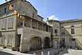
- The town hall ( Hôtel de Ville ) dates from the 17th century. The Hôtel des Barons de Chabert has been the seat of the mayor since 1888 . In 1889 the building was equipped with a tower clock that strikes a 250 kg bell that can be heard from afar.
- The city wall (Bàrri) from the 9th century with the Porte Calendrale or Sarrasine and the Porte du Séquier
- The Porte Calendrale dominated the northern entrance in the city wall ( location ). It was built in 1253, which was documented in 1302. It originally had two towers that were destroyed in 1752. The actual gate has been preserved and was restored in 1985. To the right and left of the gate opening you can see the grooves through which the portcullis was lowered in case of danger. The town hall was to be built above the town gate by resolution of August 16, 1654. However, the project was not carried out due to lack of space. In 1724 the portcullis was declared redundant and auctioned for 13 pounds per hundredweight.
- A remnant of the old city wall from the 9th century forms the southern boundary of the cours . A well, Grand puits , was dug here in 1370 and is 36 m deep and 6 m deep. At the suggestion of the Marquis de Puget de Barbentane, it was given a plaque in 1858 and embellished in 1880. It served to supply the entire upper town with water.
- Notre Dame Church (12th century) and its tower (1486/1492)
- La maison des Chevaliers de Malte (built in 1133), former manor house of the Marquis Guillaume de Barbentane, one of the feudal men of the Bishop of Avignon, by Emperor Barbarossa . The north wing on the hexagonal tower was redesigned and used as the mayor's office from 1670 to 1888. The property has been a monument historique since 1929 .
- The Séquier Gate ( la Porte de Séquier ) at the southern end of the Rue de Séquier formed the southern exit of the medieval city wall. In the course of the 1997 restoration, the coats of arms were lost, especially the salamander, a gift from King Francis I , who visited the city in 1516.
- If you go west from here through the Chemin des Moulins , you will first pass the " Moulin de Bretoule" : The mill was in operation until 1845 when it became unprofitable due to the advent of steam engines. The last owner, Claude Berlandier, had a speech impediment: he stuttered, in Provencal bret . This is how the mill got its name Moulin Bretoule .
- A little further you reach a lookout point with a wonderful view over the Rhone Valley with the Durance estuary in the north of the city.
- La Tour Anglica was built between 1365 and 1367 on the orders of the Bishop and Vicar General of Avignon, Anglic de Grimoard (1320-1388). The tower was intended to monitor the plain at the mouth of the Durance in the course of the approach of the mercenaries "unemployed" during the Hundred Years War because of the ceasefire at that time (1360-1369) . The tower was built on the site of a 9th century castle. At the same time, the city walls were reinforced. The tower is 28 m high and has a floor plan of 10 × 10 m. 140 steps lead to the top of the tower. The tower has been a monument historique since 1925 and is a listed building. From above you can see the hills of the Gard in the north-west, Avignon with the Papal Palace in the north and, in good weather, the Mont Ventoux in the north-east with its 1,912 m.
- The Montagnette : The range of hills covers an area of around 6000 hectares, of which 1350 hectares are in the Barbentane area.

Porte Calendrale, the former city gate
Maison des Chevaliers

Maison des Chevaliers, partial view of the north wing

Town hall ( Hôtel de ville ), since 1888 with clock and bell lantern

Notre Dame Church


Web links
- Official website of Barbentane
- Barbentane on the Insee website