Barre (Vermont)
| Town of Barre | ||
|---|---|---|
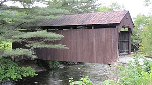
 Robbins Nest Covered Bridge |
||
| Location in Vermont | ||
|
|
||
| Basic data | ||
| Foundation : | November 6, 1780 | |
| State : | United States | |
| State : | Vermont | |
| County : | Washington County | |
| Coordinates : | 44 ° 11 ′ N , 72 ° 29 ′ W | |
| Time zone : | Eastern ( UTC − 5 / −4 ) | |
| Residents : | 7,924 (as of 2010) | |
| Population density : | 99.8 inhabitants per km 2 | |
| Area : | 79.5 km 2 (approx. 31 mi 2 ) of which 79.4 km 2 (approx. 31 mi 2 ) is land |
|
| Height : | 301 m | |
| Postal code : | 05641 | |
| Area code : | +1 802 | |
| FIPS : | 50-03250 | |
| GNIS ID : | 1462036 | |
| Website : | www.barretown.org | |
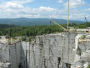
 The Rock of Ages quarry, which is still active today |
||
Barre is a town in Washington County in the state of Vermont in the United States with 7,924 inhabitants (according to the 2010 census).
geography
Geographical location
Barre lies on a plateau of the Green Mountains and has neither special watercourses nor remarkable mountain ranges; the terrain is mainly gently undulating.
Neighboring communities
All information as air lines between the official coordinates of the places from the 2010 census.
- North: East Montpelier , 3.2 miles
- Northeast: Plainfield , 5.5 mi
- East: Orange , 14.3 km
- Southeast: Washington , 4.3 mi
- South: Williamstown , 4.8 mi
- Southwest: Northfield , 15 mi
- West: Berlin , 15.0 km
- Northwest: Montpelier , 6.9 mi
Note: There is no common border between Barre, Montpelier and Northfield; however, the two localities are so close to the Barre borders that it makes sense to include them in this list.
City structure
There are several settlement areas in Barre : South Barre , Websterville , Lower Websterville , Granitville , Upper Granitville, and Wildersburg Common .
climate
| Barre, Vermont | ||||||||||||||||||||||||||||||||||||||||||||||||
|---|---|---|---|---|---|---|---|---|---|---|---|---|---|---|---|---|---|---|---|---|---|---|---|---|---|---|---|---|---|---|---|---|---|---|---|---|---|---|---|---|---|---|---|---|---|---|---|---|
| Climate diagram | ||||||||||||||||||||||||||||||||||||||||||||||||
| ||||||||||||||||||||||||||||||||||||||||||||||||
|
Average monthly temperatures and rainfall for Barre, Vermont
Source: www.weatherbase.com
|
|||||||||||||||||||||||||||||||||||||||||||||||||||||||||||||||||||||||||||||||||||||||||||||||||||||||||||||||||||||||||||||||||||||||
The mean average temperature in Barre is between −8 ° C in January and 19 ° C in July. This means that the place is around 10 degrees cooler than the long-term average in the USA. The snowfall between mid-October and mid-May is up to six meters, about twice as high as the average snow depth in the USA, the daily sunshine duration is at the lower end of the range of values in the USA, and in the period from September to December even significantly less.
history
Proclaimed on November 6, 1780 under the name Wildersburgh , the town quickly developed into a well-developed pasture and farmland. The fertile soils and the good irrigation of the area promoted the usual agricultural products, on the one hand, cattle and sheep breeding (2,826 cattle and 8,997 sheep were recorded for 1840), and on the other hand, the construction of water mills that refined and processed these products. Even mechanical wool combing is documented for 1840; not a matter of course in Vermont back then.
However, the residents of the village did not like the name of their town . So in 1793 they agreed to change the name. A citizens' meeting was called for this purpose, but it did not lead to any result. Two proposals, each the place of origin of two respected citizens, remained tied at the end. The decision was ultimately made through a boxing match; the winner determined the name Barre (after Barre in Massachusetts ) as the new name of the town . This has been the official name of the municipality since October 19, 1793. The administrative structure of the county was set up six months earlier, on March 11, 1793.
In the predominantly slightly undulating landscape, two large granite rocks caught the eye from the start: Cobble hill and Millstone hill . Both rocks rise about 140 meters from their surroundings and are made of very finely structured, light gray granite. A large number of quarries were built on these blocks, the production of which quickly became known and popular in Vermont and - after the railroad reached the community in 1850 - throughout the United States. For example, the state house in nearby Montpellier, Vermont's seat of government, was built entirely from the granite from these quarries.
In the following decades, the quarries proved to be an attraction for immigrants from various European countries, so that in Barre, on the one hand, the population rose sharply (from around 2,000 in 1840 to around 10,000 in 1880), and on the other, specialists such as sculptors and stone breakers preferred to settle down in town . This made Barre the center of Vermont's granite production and an important supplier for the entire United States.
The population growth led to the establishment of Barre City in 1895 as a spin-off of the largest settlement core in the town as an independently administered municipality.
With the economic slump caused by the Great Depression of 1929, the market for high-quality granite also collapsed. The quarries were mostly shot; to this day only one is in permanent operation: the Rock of Ages . A few more quarries will be put into operation if necessary; the number of permanent workers in the quarries has fallen to 79. Today the predominant industry is again agriculture; But even today there are still many stone processing companies and sculptors in the city and town. Some medium-sized companies as well as a Bombardier car factory benefit from the proximity of the Montpelier economic center and also settle here.
Religions
All major New England Christian faiths are represented by their own churches in the town.
Population development
| Census Results - Town of Barre, Vermont | ||||||||||
|---|---|---|---|---|---|---|---|---|---|---|
| year | 1700 | 1710 | 1720 | 1730 | 1740 | 1750 | 1760 | 1770 | 1780 | 1790 |
| Residents | 76 | |||||||||
| year | 1800 | 1810 | 1820 | 1830 | 1840 | 1850 | 1860 | 1870 | 1880 | 1890 |
| Residents | 919 | 1669 | 1955 | 2012 | 2126 | 1815 | 1839 | 1882 | 2060 | 6812 |
| year | 1900 | 1910 | 1920 | 1930 | 1940 | 1950 | 1960 | 1970 | 1980 | 1990 |
| Residents | 3346 | 4194 | 3862 | 4280 | 4052 | 4145 | 4580 | 6509 | 7090 | 7411 |
| year | 2000 | 2010 | 2020 | 2030 | 2040 | 2050 | 2060 | 2070 | 2080 | 2090 |
| Residents | 7602 | 7924 | ||||||||
Economy and Infrastructure
traffic
Barre, the City and the Town, are served by several highways, including US Highway 302 , Edward F. Knapp State Airport and the New England Central Railroad , which operates a joint station for Barre and Montpelier and is served daily by a long-distance train .
Public facilities
In Barre, besides the usual municipal facilities and public schools up to the middle school, no additional public facilities are represented. The closest hospital is the Central Vermont Medical Center in neighboring Berlin.
education
In Barre, an elementary and middle school, Barre City Middle and Elementary School, and Spaulding High School are available as public schools. They are located in the City of Barre, which runs a joint school administration with the Town of Barre. In addition, the Barre Technical Center , also in the city, offers vocational training in technical professions.
Personalities
Note: Due to the lack of a distinction in the biographies as to whether the persons listed here were born in the Town of Barre or the City of Barre, this information is the same in both articles.
sons and daughters of the town
- Socrates N. Sherman (1801–1873), politician and Vermont representative in the US House of Representatives
- Emeline Meaker (1838–1883), murderess, was the first woman to be hanged in Vermont
- Deane C. Davis (1900–1990), politician and governor of Vermont
- Charles Poletti (1903–2002), politician and governor of New York State
- William Bradford (1905–1959), Hollywood cameraman
- James F. Milne (born 1950), politician and lawyer who Secretary of State of Vermont was
- Phil Scott (* 1958), politician and Lieutenant Governor of Vermont
- Miranda July (* 1974), artist
- Elizabeth Stephen (* 1987), cross-country skier
Personalities who have worked on site
- James Fisk (1763-1844), lawyer and Vermont representative in the US Congress; Barre lawyer
- Lucius Benedict Peck (1802–1866), lawyer and Vermont representative in the US House of Representatives; Barre lawyer
- J. Ward Carver (1881-1942), lawyer and politician, the Vermont Attorney General was
literature
- Zadock Thompson: History of Vermont: natural, civil, and statistical, in three parts . 3rd volume. George H. Salisbury, Burlington 1842, p. 9 ff . ( limited preview in Google Book search). for history up to 1840 (English)
- Thomas Nelson Dale: The Granites of Vermont . US Government Printing Office, Washington 1909 ( limited preview in Google Book search). (Also available as PDF for download on the United States Geological Survey website )
Web links
- Homepage of the municipality (English)
- Profile of the community on the official portal www.Vermont.gov (English)
- Summary of current Granite centers UVM.edu (English) ( Memento of 30 June 2013 Internet Archive )
- Entry on VirtualVermont (English) ( Memento from November 15, 2017 in the Internet Archive )
Individual evidence
- ^ Barre in the United States Geological Survey's Geographic Names Information System , accessed October 1, 2014
- ↑ Population data from the 2010 US Census in the American Factfinder
- ↑ Coordinates of the locations of the Census Authority 2010 (English)
- ↑ Climate data at www.City-Data.com (English)
- ↑ Population 1790–2010 according to the census results
- ↑ Homepage of Spaulding High School (English)

